Annex "Salt marshes"
Annex I: Methods
Table I.1: Overview of available monitor data of salt marshes for salt-marsh vegetation in the countries covering the whole area (GIS data, based on aerial photographs and ground truth covering the whole Wadden Sea area).
1) Rotating monitoring schedule of sites with an interval of 5–7 years (since 1980), VEGWAD-programme, Ministry of Infrastructure and Environment (Table I.2)
2) Salt marshes on the Halligen and islands excluded
3) Inventory of salt marshes: Ribe Amt, 2002: Strandenge i Ribe Amt – Status 2000
4) Survey of salt marshes inside the Natura2000 site in the Wadden Sea area
5) In the framework of the Danish NOVANA programme
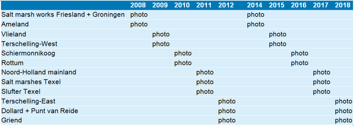
Table I.2: VEGWAD monitoring programme 2008 – 2018 in the Netherlands: 6 year-cycle of vegetation mapping in the VEGWAD-programme by Rijkswaterstaat. Publication of the vegetation maps is planned two years after aerial photographs are taken.

Annex II: Distribution of TMAP vegetation types and habitats
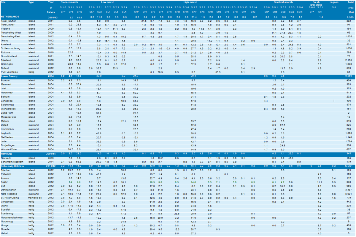
Table II.1: Incidence of vegetation types across the Netherlands and German sectors of the Wadden Sea specified per island, and on the mainland coast per region or site based on the most recent survey per sector.
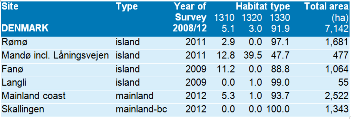
Table II.2: Incidence of salt-marsh habitat types in the Danish Wadden Sea based on the most recent survey.

Annex III: Inventory of recent accretion studies in Wadden Sea salt marshes
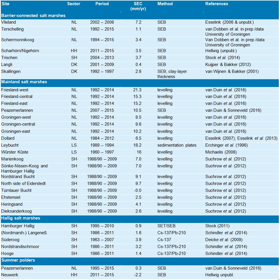
Table III.1: Inventory of surface-elevation change (SEC) in Wadden Sea salt marshes. The table presents the data that were used to compile Figure 12. Each site was considered as a single case. Spatial resolution per site varied greatly, for example from 3 Sedimentation-Erosion-Bar (SEB) stations on Vlieland up to almost 10 km of levelling transects in the Dollard. In case of repeated measurements, surface-elevation change was based on the difference in surface elevation between the first and last measurement.
ReferencesDeicke, M., V. Karius & H. von Eynatten. 2009. Bestimmung der Sedimentaufwachsraten auf den Halligen Hooge, Langeness, Nordstrandischmoor und Süderoog Sedimentakkumulation Halligen (SAHALL), Endbericht. Forschungskooperation zwischen dem Geowissenschaftlichen Zentrum (Abteilung Sedimentologie/Umweltgeologie) der Georg-August-Universität Göttingen Stiftung Öffentlichen Rechts und dem Ministerium für Landwirtschaft, Umwelt und ländliche Räume des Landes Schleswig-Holstein (MLUR), Referat Küstenschutz, Hochwasserschutz und Häfen. 76 pp. Erchinger, H. F., H.-G. Coldewey & C. Meyer. 1996. Interdisciplinäre Erforschung des deichvorlandes in Forschungsvorhaben ‘Erosionsfestigkeit von Hellern’. Die Küste 58: 1–45. Esselink. P. 2006. Hoogteontwikkeling van de Kroon’s Polders (Vlieland). Monitoring over de periode 2002 – 2006 door middel van sedimentatie-erosie-balk metingen. Rapport 2006-137, Koeman en Bijkerk bv, Haren. 28 pp. Esselink, P. 2007. Hoogteontwikkeling verwaarloosde landaanwinningskwelder. Opslibbing van de Dollardkwelders in de periode 1991–2003 met een vergelijking over de periode 1984 – 1991. Rapport 2007-009, Koeman en Bijkerk bv, Haren. 36 pp. Esselink, P., P. Daniels & P. Weerstand. 2013. De hoogte van de Dollardkwelders in 2012: Beschrijving van de uitgangssituatie in het kader van het Kwelderherstelprogramma Groningen. PUCCIMAR rapport 10. PUCCIMAR Ecologisch Onderzoek & Advies, Vries. 31 pp. Kuijper, D.J.P & J.P. Bakker. 2012. Below- and above-ground vertebrate herbivory and abiotic factors alternate in shaping salt-marsh plant communities. Journal of Experimental Marine Biology and Ecology 432–433: 17–28. Michaelis, H. 2008. Langzeitstudie zur Entwicklung von Höhenlage, Sediment, Vegetation und Bodenfauna in Landgewinnungsfeldern. Untersuchungsbericht 02/08 . Niedersächsischer Landesbetrieb für Wasserwirtschaft, Küsten- und Naturschutz, Forschungsstelle Küste, Norderney. 60 pp. Schindler, M., V. Karius, A. Arns, M. Deicke & H. von Eynatten. 2014. Measuring sediment deposition and accretion on anthropogenic marshland e Part II: The adaptation capacity of the North Frisian Halligen to sea level rise. Estuarine, Coastal and Shelf Science 151: 246-255. Stock, M. 2011. Patterns in surface elevation change across a temperate salt marsh platform in relation to sea-level rise. In: V. Karius, H. Hadler, M. Deicke, H. von Eynatten, H. Brückner & A. Vött (eds): Dynamische Küsten – Prozesse, Zusammenhänge und Auswirkungen, Coastline Reports 17, Göttingen, Mainz & Köln, pp. 33–48. Stock M., J. Baer & M. Mercker. 2014. Trischen - wax and wane of a Wadden Sea island. In: U. Hellwig & M. Stock (eds), Dynamic Islands in the Wadden Sea. Wadden Sea Ecosystem no.33, Common Wadden Sea Secretariat, Wilhelmshaven, pp. 65–97. Suchrow, S., N. Pohlmann, M. Stock & K. Jensen. 2012. Long-term surface elevation changes in German North Sea salt marshes. Estuarine, Coastal and Shelf Science 98: 71–83. van Dobben, H. A.V. de Groot, K.S. Dijkema, E.C. Koppenaal, J.P Bakker & P. Slim. (in prep.). Medium-term salt-marsh accretion: determining factors and resilience against sea-level rise. van Duin, W.E., H. Jongerius, A. Nicolai, J.J. Jongsma, A. Hendriks & C. Sonneveld. 2016. Friese en Groninger Kwelderwerken: Monitoring en beheer 1960 – 2014. Wettelijke Onderzoekstaken Natuur & Milieu, Wageningen University & Research. WOt-technical report 68, Wageningen. 91 pp. van Duin, W.E. & C. Sonneveld. 2016. Vegetatie en opslibbing in de Peazemerlannen en het referentiegebied West-Groningen: Jaarrapport 2015. Imares-rapport C041/16, Den Helder. 62 pp. van Wijnen. H.J. & J.P. Bakker. 2001. Long-term surface elevation change in salt marshes: a prediction of marsh response to future sea-level rise. Estuarine, Coastal and Shelf Science 52: 381–390. |


