. Zuiderduin 2011.")
Photo: Rijkswaterstaat, NL (https://beeldbank.rws.nl). Zuiderduin 2011.
Geomorphology
A. P. Oost, C. Winter, P. Vos, F. Bungenstock, R. Schrijvershof, B. Röbke, J. Bartholdy, J. Hofstede, A. Wurpts, A. Wehrmann
PDF1. Introduction
The hydro- and morphodynamic processes of the Wadden Sea form the foundation for the ecological, cultural and economic development of the area. Its extraordinary ecosystems, its physical and geographical values and being an outstanding example of representing major stages of the earth’s history are factors why the Wadden Sea received a World Heritage area qualification (UNESCO, 2016). During its existence, the Wadden Sea has been a dynamic tidal system in which the geomorphology of the landscape continuously changed. Driving factors of the morphological changes have been: Holocene sea-level rise, geometry of the Pleistocene surface, development of accommodation space for sedimentation, sediment transport mechanisms (tides and wind) and, the relatively recent, strong human interference in the landscape.
In this report new insights into the morphology of the trilateral Wadden Sea gained since the Quality Status Report (QSR) in 2009 (Wiersma et al., 2009) are discussed. After a summary of the Holocene development (sub-section 2.1), the sand-sharing inlet system approach as a building block for understanding the morhodynamic functioning of the system with a special emphasis on the backbarrier (sub-section 2.2) is discussed, followed by other parts of the inlet-system. The foreshore and the ebb-tidal delta development is discussed in sub-section 2.3, the islands in sub-section 2.4 and the islets in sub-section 2.5. The morphology of the estuaries is discussed separately (see report on "Estuaries").
2. Status and trends
2.1 Holocene development
From 8000 BC onwards the lower parts of Pleistocene valleys of rivers, such as Elbe, Weser and Ems were inundated and changed into tidal basins. At the landward side of these basins peat was formed. During the period around 2000 BC, sea level rise slowed down and the sediment infill of the basins could keep up with it. At the borders, sedimentation was faster than sea-level rise, salt-marsh areas extended seaward and coastal peat marshes increased in size. During the period between 500 BC and 1500 AD, several marine ingressions occurred, due to subsidence of the marshland surface in the hinterland. The subsidence had natural and anthropogenic causes. A natural cause was penetration of tidal creeks which drained and lowered the peat, after which clay deposited on top of it, leading to further subsidence. In the last part of the Holocene, subsidence was mainly due to agriculture and diking. With the beginning of dike construction, coastal lowlands and marshes became decoupled from marine sedimentary processes. The peat of the farmlands compacted, but there was no compensation by clay deposition. Storm surges have had large-scale morphological effects by flooding these lands. The peat area became lower due to drainage, erosion and compaction of the peat areas leading to land loss (e.g., Jade Bay & Ems-Dollard, Figure 1). In addition, new accommodation space was created due to the on-going sea level rise, which, on the mud- and sand flats, could not always be filled up due to sediment deficits (Chang et al., 2006). Since the systematic construction of modern dykes, the coastline of the Wadden Sea has become relatively stable. as such it is a significant change in the long-term trend.

Figure 1. Schematised cross-sectional reconstruction of the Dollard area (E=W) between 1000 and 2000 AD (Vos & Knol, 2015).
In the previous QSR (Wiersma et al., 2009), several distinctive regional palaeogeographical maps were reconstructed for the trilateral Wadden Sea (Wiersma et al., 2009). Recently, strongly improved versions have been produced for the Dutch and German Wadden Sea (Appendix I; Vos & Bungenstock, 2013; Vos & Knol, 2013; Vos, 2015). Behre and others compiled Lower Saxony coastline maps and palaeogeographical maps of the Jadebusen (Behre 2004, 2012; Karle et al., 2016). Homeier et al. (2010) compiled historical data from the past 500 years within a GIS-based framework. In Schleswig-Holstein and in the Elbe region, valuable landscape reconstructions for the past two millennia have been made (Meier, 2006, 2014; Lindhorst, 2007; Meier et al., 2014). Pedersen et al. (2009) reconstructed the Holocene development of the Varde Å Estuary in Denmark. Fruergaard et al. (2013, 2015a, 2015b) reconstructed the Holocene development of the Danish barrier islands. Together, these reconstructions provide an overview of the major changes due to natural forcing and the interference of man.
In modelling the short- and long-term effects, palaeo-tidal landscape reconstructions are a useful tool to understand and predict morphological changes for different sea level scenarios (the past as key to the future). The palaeogeographic 4D model reconstructions can be used to calibrate numerical models for landscape changes of the Wadden Sea area in the close and more distant future. Besides for modelling purposes, the palaeo-landscape maps can also be a useful ‘landscape-reference’ to develop the nature policy and management of the Wadden Sea area.
2.1.1 Holocene sea level riseFor the trilateral Wadden Sea coast, several sea level curves have been published based on different methodological approaches (e.g., Jelgersma, 1979, Roep & Beets, 1988, van de Plassche & Roep, 1989, Denys & Baeteman, 1995, Behre, 2007, Bungenstock & Schäfer, 2009, Pedersen et al., 2009). Vink et al. (2007) show the differences of the sea level curves along the North Sea coasts of The Netherlands and Germany as a result of glacio-isostatic adjustment (GIA) during the Holocene as earlier discussed by Kiden et al. (2002). The GIA is probably one of the main reasons for differences in relative height of sea level data over time, but also local factors as tidal conditions, sediment budget and, most important, paleogeography are influencing the development of sea level induced local water levels. Therefore, coastal sections are represented by their own local sea level curves directly linked to the palaeogeographic development (Bungenstock & Weerts, 2011, 2012, Baetemann et al., 2011). |
2.1.2 Formation of the Wadden Sea islandsThe bulk of the sediments which form the barrier islands consist of locally reworked Pleistocene sediments selected, transported and deposited by marine processes into the Wadden Sea as demonstrated by the mineralogical composition (e.g., Winkelmolen & Veenstra, 1974, Veenstra & Winkelmolen, 1976). Mud was mainly brought in with North Sea water, whereas the deposited sand mainly derives from the North Sea coasts. About 10 % of the sediments are of fluvial origin (Hoselmann & Streif, 2004). The bulk of the West and East Frisian barrier island chain formed between 6000-5000 BP (for budget studies see: Beets & Van der Spek, 2000; Hoselmann & Streif, 2004). At first, sedimentation rates were insufficient to fill the accommodation space created by the rapidly rising sea (1 m/century). Much of the inundated backbarrier area evolved into subtidal environments, fringed at the landward side by a narrow zone of intertidal sand and mud flats and salt marshes. At about 5000 BP, decelerating rates of sea level rise were exceeded by sediment accumulation rates so that intertidal sand flats grew at the expense of subtidal environments (Van Heteren & Van der Spek, 2003, Vos et al., 2011). As a result of the sediment transport into the backbarier area, the barrier islands coasts eroded. Due to erosion and slow flooding, the islands (which do not receive much sand from deeper water or coast parallel transport) slowly retreated. At about 5000 BP, the West and East Frisian barrier-island chain was still situated several kilometres offshore from its present position, e.g., in the case of Terschelling about 9.5 km further to the north compared to its present position (Sha, 1990a,b, Vos et al., 2011). From 5000 BP until today, the chain of barrier islands has been retreating landward at an average migration rate in the order of 1-2 m/year. A relative sea level rise of circa 12 m over the past 8400 years occurred in the northern part of the North Frisian barrier coast (Pedersen et al., 2009). In combination with abundant sediment supply, Sylt developed its northern spit as of 5000 BP (Lindhorst, 2007), whereas Rømø prograded seaward since 8000 BP (Madsen et al., 2010). In the southern part of the North Frisian area (among others Eiderstedt), the barriers and Pleistocene outcrops in the area created an inlet-segmented coastline around at least 5000 BP (Vollmer et al., 2001; Meier, 2004; Lindhorst, 2007). On the peninsula of Eiderstedt, the cores of the modern east-west trending sand bars probably consist of eroded Pleistocene material and are a relic of this barrier system (Hoffmann, 2004). The sandy barrier system protected the hinterland and around 2,500 years ago, extensive marshes formed, consisting of thick sequences of clayey and peaty sediments with small-scale relief due to differential compaction (Meier, 2004). Although a large part of these marshes eroded during medieval times, remnants still dominate the morphology of the area. Seaward of the marshes, tidal flats began to form as for example, documented on Hallig Hooge and Pellworm (Vollmer et al., 2001). |
2.2 Inlet systems
Since 2010, the Delta Program is carried out to safeguard the Netherlands from flooding resulting from climate change and to provide sufficient amounts of fresh water. Part of the Program focuses on the Wadden Sea, partly in cooperation with the trilateral partners. Central in all studies stands the notion that the Wadden Sea consists of sediment sharing inlet systems. Each consists of a back-barrier tidal basin (with tidal flats and channels), an ebb-tidal delta and barrier islands at either side of the inlet (Figure 2). All elements of the system are coupled and are assumed to be in, or evolving towards, a dynamic quasi-equilibrium with the hydrodynamic conditions (Dean, 1988; Eysink, 1991; Eysink & Biegel, 1992; CPSL, 2001, 2005, 2010). Changes in any part of a tidal-inlet system will primarily be compensated by sediment transport (mainly sand) to, or from, the other parts of the same system (Figure 2; Oost et al., 1998, 2012; Elias et al., 2012a; Wang et al., 2012). On the longer run net sediment import into the inlet system from adjacent systems may occur. Also, tidal flows and water shed shifts may lead to sediment transport from one basin into another one (see Table 2.3).
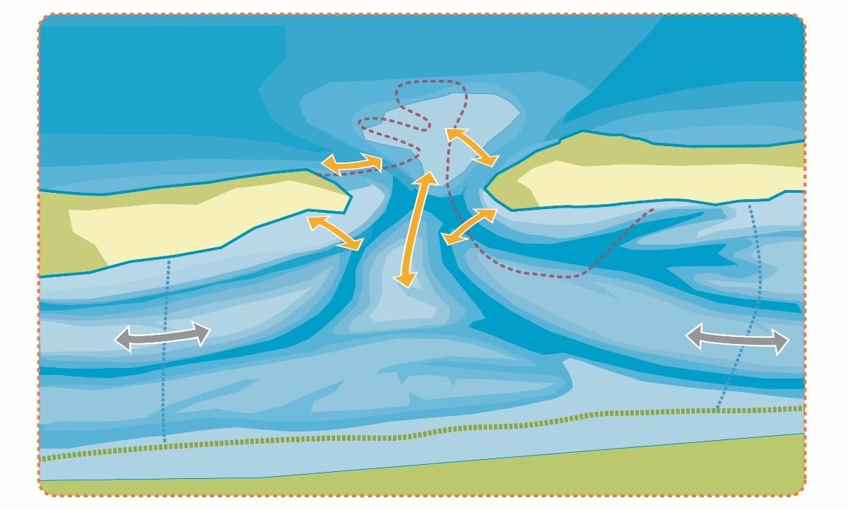 Figure 2. Schematic sediment exchange between the three main elements of a sediment sharing tidal inlet system given by arrows. In reality sediment exchange paths can be very complicated and strongly depend on local morphology, since tidal currents as well as waves are driving the transport. This is illustrated by a schematic path of sediment exchange given by the dashed red line. Furthermore, the tidal inlet systems also exchange sediment via the watersheds; here illustrated with grey arrows.
When changes in boundary conditions/drivers are temporary (e.g., perturbations by storm surges) or limited (e.g., subsidence by mining activities or dredging), the morphodynamic quasi-equilibrium may be restored. If changes are more permanent (e.g., higher rates of sea level rise or decrease in tidal volumes), a new dynamic quasi-equilibrium may develop. Several tidal basins in the Wadden Sea (but not all, e.g., Lister Tief, Reise et al., 1996) are nowadays silting up faster (up to four times) than the observed sea level rise. This is often the result of human-induced perturbations, such as at the Ley Bay, Zuiderzee and Lauwerszee (Dissanayake & Wurpts, 2013; Dissanayake et al., 2012, Figures 2.3, Table 2.I; Elias et al., 2012a). How fast a dynamic quasi-equilibrium can (re-)establish depends on the magnitude of the perturbation, the sediment availability and transport capacity. At the moment it is not clear which of the two latter is the most important. The limits to the extent to which a basin can keep up with relative sea level rise are one of the major focus points in trilateral sea level rise research (CPSL, 2001, 2005, 2010; Oost et al., 2014).
 Figure 3. Maps of the Dutch Wadden Sea illustrating the configuration of the inlets, basins, channels and shoals for the years 1927-1935 (large Figure) and 2005 (lower right; Elias et al., 2012a).
Many mechanisms drive net import such as tidal asymmetries, estuarine circulation, temperature driven sedimentation, biota, wind-wave-driven transport, settling and scour lag etc. It is assumed that an increase in sediment transport is mainly possible by an increase in the volumes of tidal- or storm-surge water transport (Hofstede, 2015) or if sediment availability increases. Reversely, fine-grained sediment might not be able to deposit if changes occur as increases in turbulence hinder this. Under relatively higher sea levels, hydrodynamic energy no longer fades out in a transitional zone and mudflats and salt marshes may disappear (Mai & Bartholomä, 2000; Wehrmann, 2014).
At the moment there is trilateral discussion on the mechanisms and the upper limits of sediment transport. Both are essential to understand the resilience of the sedimentary systems to climate change (i.e., sea level rise) and to human use (such as subsidence due to gas mining).
Table 1. Overview of sedimentation in the Dutch Wadden Area (Elias et al., 2012). Note for the period 1935-2005 that the coast of Texel erodes with 376 million m3, whereas the backbarrier basin silts up with 234 million m3: a large part of the sediment is carried over the watershed into the Vlie Basin.

Closed sediment balanceBased on erosion-sedimentation patterns it is concluded that the Wadden Area (up to -20 m line in the North Sea nowadays (and probably also in the past) forms a nearly closed system for sand transport (Oost et al., 1998; Elias et al., 2012a). There is a small net sediment transport from West to East along the West- and East Frisian Islands and a small net sediment transport from North to South along the North Frisian Islands. Furthermore, the clastic material brought in by the Ems, Weser, and Elbe rivers during the last 7500 years is only 10 % from the total Wadden Sea deposits (Hoselmann & Streif, 2004). In the German Bight, storm surges are known to transport a small volume of sand offshore (Aigner, 1985). Furthermore, it has been shown that during exteme events of short time scales only, transports can go in both directions (Bartholomä et al. 2008). As a result, the major part of the Wadden Sea sediments consists of Pleistocene sands which have been re-worked several times during Holocene transgression. Sand deposited in the back-barrier area is mainly derived from the North Sea coasts of the barrier islands and the ebb-tidal deltas. As a result the island’s coasts and ebb-tidal deltas have a long-term tendency to retreat in a landward direction. Nowadays this is countered by sand nourishments and other coastal protection measures. Mud is mainly brought in with North Sea water. It originates mainly from the rivers Rhine, Meuse, Thames, Ems, Wese, Elbe, or is eroded from the Canal Coast. A tenth of the total deposits consists of mud. |
2.3 Shoreface area and ebb-tidal deltas
The shoreface reach is situated between the low water line and the depth of closure, which is defined as the position on a coastal profile beyond which there is no significant change in bottom elevation or sediment transport between the nearshore and the shoreface for a characteristic time interval (Krauss et al., 1998). The concept was established on the observation that the magnitude of sediment transport becomes increasingly smaller with increasing depth, implying that the effects on morphology could be neglected below a certain depth (Bruun, 1962). The concept of the depth of closure is widely used in practical applications (sand extraction, coastal stability) as it defines the extent of the active (dynamic) coastal profile (Capobianco et al., 1997). In the Wadden Sea, this notion is influential to management. For instance, the Netherlands currently use the -20 m Dutch Ordnance Level line as a “safe” depth of closure. However, recently it was argued that this depth might be too large based on various arguments (Koomans, 2000; Schroevers et al., 2014; van Oeveren-Theeuwes et al., 2015). Up to now there is not an official trilateral agreement on the depth of closure.
") Figure 4. Oblique view of the ebb-tidal delta of Texel Inlet (Marsdiep), red scale in the inlet is 2 km, based on 2004 depth soundings; colours indicate depths (blue deepest) (source: RWS).
Figure 4. Oblique view of the ebb-tidal delta of Texel Inlet (Marsdiep), red scale in the inlet is 2 km, based on 2004 depth soundings; colours indicate depths (blue deepest) (source: RWS).
Ebb-tidal deltas (Figure 4) play an essential role in the sedimentary development of inlet systems. They are the intermediate in sediment exchange between the open sea, the barrier islands and the tidal basins. For the ebb-tidal deltas a semi-circular sediment transport pattern, in which the sediment is constantly being recycled is assumed (Son et al. 2011), so that sand can be transported from island to island without decreasing the sediment volume of the ebb-tidal delta. Also, they dissipate the wave energy and provide shelter to parts of the islands and to the adjacent back-barrier area. Driving forces (tide, wind and waves) exert a strong influence on the morphology of ebb-tidal deltas which are continuously changing (Sha & Van den Bergh, 1993; Herrling & Winter, 2014). Changes in the driving forces will therefore lead to morphological changes (Ridderinkhof, 2016), which may influence development of other parts of the system. Therefore, knowledge about ebb-delta development under different drivers (Herrling & Winter, 2014) is essential to our understanding of the sediment sharing inlet system. The interaction between tide, wind and waves is a complex process that needs to be unravelled for an optimal management of the coastal zones while reducing flood risks to the coastal settlements. At the moment, the observed erosion of ebb-tidal deltas as well as other form changes and the implications are reasons for concern (see inset).
Inset: Reduction of the ebb-tidal deltaDecreasing Dimensions Sediment supply Sheltering effects In contrast to Schleswig-Holstein, Denmark is currently facing hardly any problems with its ebb-tidal deltas. There is a positive sediment budget, resulting from onshore transport from the North Sea and substantial long-shore transport from the Jutland peninsula (Nielsen & Nielsen, 2006; Madsen et al., 2010). Except for the ebb-tidal delta off the Grådyb Inlet, which is dredged, the other ebb-tidal deltas are currently stable in volume or even growing. |
2.4 Barrier islands
Barrier islands play an important role in the long-term exchange of sediment, as a source or sink of sediments (mud and sand). Historical observations show that the long-term development of barrier island volumes is especially related to (Davis, 1994):
- Presence of Pleistocene core (Sylt, Texel, Amrum, Föhr);
- Shifts in position of the inlets (Dean, 1988; Sha, 1990b; Elias, 2006);
- Shifts of marginal ebb-tidal delta channels (van Veen, 1936; Joustra, 1971; Oertel, 1977; Oost, 1995; Schoorl 1999a&b; van Heteren et al., 2006);
- Sediment delivery from the ebb-tidal delta (Van Veen, 1936; Oertel, 1977; Sha, 1990b; Israel & Dunsbergen, 1999; Schoorl, 1999a&b; Van Heteren et al., 2006);
- Wind driven sediment transports (Aagaard et al., 2007; Arens, 1999; Arens et al., 2007, 2008a&b);
- Storm-surge driven sediment transport leading e.g., to wash-over formation (Ten Haaf et al., 2006; Hoekstra et al., 1999, 2009);
- Decrease in inlet cross section due to decrease in tidal basin volume (Flemming & Davis, 1994);
- Coastal erosion (Hofstede, 1994a; Elias et al., 2012a,b);
- Back-barrier erosion by barrier-ward channel migration (Oost, 1995);
- Tidal marsh sedimentation.
The development of barrier islands in timescales of decades to centuries is only partially known. Large amounts of sediment are involved (e.g., growth over 4 km of east-Schiermonnikoog since sediment release from the ebb-tidal delta upon the closure of the Lauwerszee in 1969; the strong erosion by a tidal channel of east-Terschelling over 2 km since 1990, but also a strong growth at the west side of Terschelling; see also: Schoorl, 1999ab, 2000ab; Ehlers, 1988, Winter, 2011; Oost & van Rooij, 2012; Oost et al., 2012). However, long-term sediment budget analysis in which the islands are included has not yet been made on basis of historical data. Now that Lidar data become available, this becomes feasible. A better knowledge and monitoring of the barrier islands, but also the behaviour of the channels in the inlets are essential for predicting the future development of islands (Arens et al., 2009).
On most islands, natural development (inlet and ebb-delta channel migration, dune migration and washover development) has been influenced by man, especially since 1900 (Thorenz, 2011; Oost et al., 2012). The sediment transport across the islands – from the North Sea to the southern parts of the islands has been blocked by fixating dunes and building sand-drift dikes. This will possibly have consequences for the resilience of the islands and the sediment sharing inlet systems as a whole. These consequences are, until now, poorly understood (Oost et al., 2012). A short overview of some important points is given in the inset.
Reduced resilience of barrier islandsHalting channel migration. On many of the German North Sea islands and some Dutch islands, ebb-delta channel and inlet migration is halted by massive hard sea defences, especially on the western island heads. Often the last way to maintain safety on the islands, but influencing free exchange of sediments along the coasts within the sediment sharing inlet systems. The coastal defences lead to a fixation and, from time to time, deepening of tidal channels along the island coasts, which leads to high costs in combatting coastal erosion. The influence on the functioning of the inlet system in terms of sediment exchange and natural dynamics is not well known. Some data even show that coastal defences result in faster erosion (Dr. Jan S. Ysker, unpublished data). Wind-driven transport. Large-scale marram planting and the building of sand fences led to the formation of massive and often fully closed sand drift dikes along the beachfront (Arens, 1999; Van der Wal, 1999; Löffler et al., 2011). In total about 1 Mm3/yr sand is trapped in the managed dunes at the North Sea side of the inhabited Dutch barrier islands (Arens et al., 2007). Eolian sand transport from the beach further into the interior of the barrier islands is hindered. Originally, eolian sand transport was a main mechanism to allow the barrier areas to accrete vertically (see e.g., De Jong, 1984). The lack of sediment import from the beach due to sand drift dikes and fixated dunes may ultimately result in a reduction of barrier elevation with respect to relative sea level. This is locally already observed in an area behind a sand drift dike on Ameland which is subsiding due to gas extraction and eolian transport is not sufficient to compensate to subsidence. The lack of eolian dynamics on many islands also resulted in a strong loss of ecosystem values due to fast plant succession (Löffler et al., 2011). Overwash transport. The washover environments often consist of low areas which are topped by waves and flooded during storm surges, transporting water and sediments from the North Sea onto and over the island. Under natural conditions it is a normal phenomenon on the Wadden barrier islands. Overwash on the Wadden Sea barrier islands is especially important for eroding and redepositing sediment of the beach and dune-face, after which eolian transport takes over (Nielsen & Nielsen, 2006, Hoekstra et al., 2009, Ten Haaf et al, 2011). The formation of sand drift dikes along the beach area blocked many of the washovers and ended their dynamics. Vegetation succession was accelerated since then and natural values of the areas are declining strongly (De Groot et al., 2015). Sediment exchange across tidal divides. Recently, a significant mass transport across tidal divides has been assessed by a numerical modelling study of the East Frisian Wadden Sea. Volumes of up to 19 % of the respective tidal prism are exchanged through the high tidal divides between Wadden Sea basins (e.g., Herrling & Winter, 2015). At several places dams are present on the tidal divides (e.g., Sylt and Rømø): their effect on overall barrier island development is not yet understood. Development of tidal marshes. In the lee of both natural and artificial dunes, tidal marshes develop while fine-grained sediments accumulate. Volume calculations for the Dutch islands indicate that these salt marshes are an important sink for cohesive sediment and fine sand (De Groot et al., 2013). Bartholdy et al. (2010) modelled the salt marsh growth on the backbarrier of the barrier-spit “Skallingen” in Denmark, and found that over a 100-year period, the back barrier could survive a future sea level rise of approximately 4 mm/y. On the tidal marshes of the low-diked Halligen of Schleswig-Holstein accretion rates are 1.2-2.6 mm/yr, which is insufficient to keep up with present day sea level rise (Schindler et al., 2014a & b). It is not known yet, whether the normal feedback mechanisms between sea level and salt-marsh sedimentation will be sufficient to let mature salt marshes grow with sea level rise, or if additional measures are necessary. An important matter is whether salt marshes on barrier islands exhibit the same natural cycles of horizontal growth and erosion as estuarine tidal marshes, i.e. whether lateral erosion is a long-term threat or not. Also, the hindered sediment supply from the North Sea by sand drift dikes is not compensated everywhere by extra input from fines from the Wadden Sea. This leads to relative deepening of the areas directly landward from the sand dike. It is not clear if it is possible to restore the original processes successfully, due to the massive changes in the area. |
2.5 Islets
In the Wadden area, 65 small islets are present, with a total surface area of over 134 km2. Most of them are uninhabited. They form one of the most spectacular examples of the outstanding geology, hydrology, morphology, ecology and biodiversity of the Wadden Sea (Hellwig & Stock, 2014). The islets can be divided into the following categories:
- Remnants of former higher areas in the backbarrier area, such as Griend (Kers, 2014), possibly also Engelsmanplaat (Oost, 1995), late Jordsand (Frederiksen, 2014), the many Halligen (six of which are inhabited) and small islets between Eiderstedt and Amrum, which formed after the flooding of a peat area around 450 AD (Meier, 2006).
- Islets forming in the outer deltas, such as Razende Bol (Sha, 1990), Rif (Oost, 1995), Rottumerplaat (Oost, 1995; van Rooijen & Oost, 2014), Noordrif (now part of Rottumeroog; Kers, 2014), Süderoogstrand (Hellwig et al., 2014) and Trischen (Stock et al., 2014; Padlat, 2014). The rate of basin-ward shifting of the islets is determined by sediment supply in conjunction with singular, mostly storm-related, events (Hofstede, 1999a).
- Ephemeral (sandbank) islets of the meso- to macro-tidal Jade-Weser-Elbe region which do not have the potential to form larger coherent dunes (Wehrmann et al., 2014). Within the inner German Bight the islands become so small that they become unstable (Hellwig et al., 2014; Führing, 2015).
- Islets formed in the inner deltas or inlet, such as Koffieboonplaat, Kachelotplate (Wehrmann et al., 2014), Mellum (Kleyer et al., 2014) and Memmert (Ehlers, 1988). Surveys on the Kachelot-plate revealed that high energy storm surges and related overwash and flooding are the most prominent drivers in barrier island evolution. The eroded sand heightens the sandy sedimentary base of the next generations of primary dunes, resulting in a decrease in inundation rates, leading to the development of stable dunes (Walters et al., 2014; Wehrmann et al., 2014).
- Islands which form part of the barrier chain and are gradually eroded. An example is Buise which broke up in two parts in 1362 of which the western part disappeared in the second half of the 17th century. Rottumeroog is a barrier island which has decayed since 1500 (Oost, 1995). It is expected that Rottumeroog will continue to migrate in a southward direction. At the long-term it is unsure if the island remains stable in volume (Van Rooijen & Oost, 2014).
- Artificial islets such as Langlütjen I & II, Nigehörn and (at least partially) islands which have been restored, such as Griend and Minsener Oldeoog.
- Estuarine islands, situated in the brackish or fresh water tidal zone of the estuaries open to the Wadden Sea.
The morpho- and ecodynamics of the 65 uninhabited islets is often locally well studied, some of them having a monitoring history of up to 120 years. Management of each of the islets has developed in reaction to the specifics of the island itself and is thus more or less tailor made. A comprehensive management philosophy which takes into account all 65 islets and deals with all aspects (ecology, safety, morphodynamics) and relations between islands (e.g., breeding birds) is missing. An inventory study and trilateral management meetings are recommended.
Table 2. Overview of all 65 islets in the trilateral Wadden Sea. Excluded are the larger inhabited barrier islands.

3. Assessment
3.1 Holocene development
There are no targets for the Holocene development within the Wadden Sea Plan, but in the Joint Declaration (2010) there is the Guiding Principle “to achieve as far as possible, a natural and sustainable ecosystem in which natural processes proceed in an undisturbed way” reaffirmed during the Tønder meeting (CWSS, 2014). For that reason it is quite important to better understand the genesis of the trilateral Wadden Sea and the influence of human interferences to derive a possible future development. Also, for Landscape and Culture Identity such knowledge will help to preserve, restore and develop the elements that contribute to the character, or identity, of the landscape, which is a target in itself (see "Landscape and culture").
3.2 Sediment sharing inlet system
For the backbarrier area, the following geomorphological targets have been formulated (Wadden Sea Plan 2010):
- A natural dynamic situation in the tidal area;
- An increased area of geomorphologically and biologically undisturbed tidal flats and subtidal areas.
From the point of overall geomorphological dynamics, the Wadden Sea tidal area is functioning relatively naturally. However, human impacts are influencing this natural system:
- Closure of the Zuiderzee in 1932 still influences sedimentation in the backbarrier areas and shoreface of Texel and Vlie Inlet (Elias et al., 2012a), whereas the closure of the Lauwerszee in 1969 still seems to influence the erosion of the ebb-tidal delta (Oost et al., 2015) and sedimentation around the island of Schiermonnikoog;
- The poldering of embayments and fixation of the coastline by dikes which happened in the previous centuries strongly decreased the tidal volume of the respective tidal basins, the area of muddy environments, limited connectivity and increased the turbidity of the Wadden Sea (Mai & Bartholomä, 2000; Hoselmann & Streif 2004, van Maren et al., 2016);
- In Schleswig Holstein and Denmark, dams between the mainland and the islands hinder the development of natural dynamics;
- In many estuaries (e.g., Elbe estuary) dredging of navigation channels has increased tidal amplitudes and has modified tidal phasing. These processes are known to affect the tidal asymmetry and residual sediment transport as well as the effects of storm events (e.g., Bolle et al., 2010; van Maren et al., 2015);
- Also other shipping lanes are maintained by dredging which leads to artificial sediment displacement and extra turbidity in the Wadden back barrier areas, sometimes combined with net removal of sediment;
- In large parts of the Wadden Sea bottom disturbance by fishing hinders the development of undisturbed tidal flats and subtidal flats and their related benthic communities. For the abiotic functioning of tidal flats it is concluded that trawling and bottom disturbance on the short run leads to a loss of mud content (Van Moorsel & Van Leeuwen, 2013), which may last over more than a year (Figure 5; pers. com. de Vlas; pers. obs. Oost). For the biotic part see report on fisheries;
- Developments furthering an increased area of undisturbed tidal flats and subtidal areas are closure to bottom disturbances of designated areas.
") Figure 5. Traces of mechanical cockle fishing on the tidal flats at Noorpolderzijl (NL) (Photo by J. de Vlas; in: Van Moorsel & Van Leeuwen, 2013).
Figure 5. Traces of mechanical cockle fishing on the tidal flats at Noorpolderzijl (NL) (Photo by J. de Vlas; in: Van Moorsel & Van Leeuwen, 2013).
3.3 Shoreface area and ebb-tidal deltas
For the shoreface and ebb-tidal deltas, the following geomorphological target has been formulated (Wadden Sea Plan 1997): An increased natural morphology of the offshore area, including the outer deltas between the islands.
Developments hindering this target are the groins and other protection works which are already existing (The Netherlands, Schleswig Holstein) or that have been extended and improved on some barrier islands of Lower Saxony after 2009 (NLWKN, 2010). These limit the natural morphological development of the inner and other deltas by means of a fixation of (parts of) the island´s coast line. The measures are deemed crucial for coastal protection of the islands. Whether these changes exert a significant influence on natural morphology is not known. Developments furthering the natural morphology are the joining of Denmark in the World Heritage area including a large part of the North Sea shoreface area and the extra extensions into the shoreface designated by Lower Saxony in 2014. Recently an overview has been given of the ebb-tidal deltas of the trilateral Wadden Sea (Oost et al., 2017).
3.4 Barrier islands
In the Trilateral Wadden Sea Plan (1997) the following targets appear:
- Increased natural dynamics of beaches, primary dunes, beach plains and primary dune valleys in connection with the Offshore Zone;
- An increased presence of a complete natural vegetation succession.
Developments hindering the targets are: expansion, maintenance or non-removal of sand drift dikes. They decrease the natural sediment dynamics which leads to a decreased presence of a complete natural vegetation succession.
Developments furthering the targets are: Since the introduction in the Netherlands of Dynamic Coastal Maintenance in 1990 several sites have been allowed to develop in a more natural way. Examples are SW Texel, some parts of Vlieland, Terschelling at the west side and at the east side, several locations at Ameland and East-Schiermonnikoog. As a compensation measure for the building of the Statoil pipeline in 2004, the summer dike in the south of Langeoog Island was destroyed to let the salt marshes develop naturally. Also, the inclusion of many natural areas on the barrier islands as parts of the UNESCO World Heritage area furthers the targets. In 2013, the Netherlands introduced the National Vision Coast aiming at a safe, appealing and economic stronger coast. This was followed by the Coastal Policy 2015 which translates the national water safety policy for coastal areas in responsibilities and limiting conditions which determine other activities. The Coastal Policy also tries to create more possibilities for other use of the coast, resilient and sustainable multi-use practices and more natural dynamics.
3.5 Islets
There are no specific targets for islets, but the targets for beaches and dunes seem to apply:
- Increased natural dynamics of beaches, primary dunes, beach plains and primary dune valleys in connection with the Offshore Zone;
- An increased presence of a complete natural vegetation succession.
Developments furthering the targets are that up to now much of the islands’ nature is allowed to take its way, although there are exceptions such as the bird reserve Griend which is nourished from time to time. This hands-off policy seems to pay off since many natural dynamic areas and species find a place on the islets.
4. Recommendations
4.1 Recommendations for monitoring & research
4.1.1 Holocene development
Palaeolandscape reconstructions of the Wadden Sea region are useful to understand and predict morphological changes within this tidal system in the future. They may provide valuable management insights for nature policy for the next 100 years for both, interference and conservation strategies (e.g., van Maren et al., 2016). However, the existing maps only cover specific regions and are not compiled for the Holocene period. Therefore, it is recommended to compile new paleogeographical maps of the entire trilateral Wadden Sea area. To give a comprehensive overview, the most important phases of the development of the Wadden Area are: 5500 BC, 3850 BC, 2750 BC, 1500 BC, 500 BC, 100 AD, 800 AD, 1250 AD, 1500 AD, 1850 AD and the present-day landscape situation. To realise the proposed trilateral palaeo-landscape maps of the Wadden Sea an international mapping program is recommended. The new reconstructions by Vos et al. (2014) and the Wadden Sea archive-reconstructions for the area of Norderney to Spiekeroog can form the on-set to such a trilateral enterprise.
4.1.2 Sediment sharing inlet system
A series of major knowledge gaps is identified considering the functioning of the sediment sharing tidal system. The overview is partially based on the various trilateral discussions and on recent inventory studies and overviews (Speelman et al., 2009, Oost et al., 2012, Elias et al., 2012a&b, Wang et al., 2012, Van Oeveren-Theewes et al., 2015):
With regard to water movement:
- What is the role of storms in the exchange of water and sediment between the neighbouring basins and between the Wadden Sea and the North Sea (Wang et al., 2012; Herrling & Winter, 2015)?
With regard to sediment transport:
- How is the observed sediment import/export generated and what will be the reactions to cli-mate change effects, especially sea level rise?
- What is the relative importance of the major sediment transport mechanisms in a Wadden Sea tidal inlet system and how do they contribute to the net import or export to and fro a backbarrier basin (Herrling & Winter, 2014)?
- To what extent is sediment availability a limiting process?
- How do morphological changes in the basin and on the ebb-tidal delta influence the processes and mechanisms which determine the net transports through an inlet?
- To what extent is the net transport to the backbarrier system influenced by the supply of extra sediment in the coastal zone?
- What are the consequences of various aspects of climate change (sea level rise, global warming, changing wind patterns, and changing precipitation/evaporation patterns) to the net sediment transport into the Wadden Sea?
- What determines the exchange of sediment between adjacent tidal basins?
- How much import of each sediment type occurs in each sediment-sharing tidal inlet system?
- Are there tipping points which might occur either due to changes in drivers or due to inherent evolution after which the sediment sharing inlet system can follow a different morphological development (e.g., Ridderinkhof, 2016)?
- What is the role of barrier islands as a source and sink for sediment as part of the sediment-sharing inlet system on the scale of decades to centuries?
Numerical models:
At the moment, most numerical models are aimed at the development of (parts of) inlet systems over the period of years. Although the mode and direction can be determined in this way, the exact development over a timespan of several decades cannot be calculated. Also, the uncertainties in this development (due to, for instance, stochastic processes and the uncertainties in the model-schematisation) cannot be assessed. There are several causes for this. On one hand there is insufficient theoretical knowledge leading to inherent limitations in the models. Currently, models are not capable of satisfactorily reaching a morphological equilibrium state. On the other hand, the models are also limited by a lack of accurate measurements over longer time spans (10-20 years), such as fresh-water discharges, currents and waves, which are needed to validate the models. In addition, several uncertainties in boundary conditions and model formulations hinder successful naturalistic long term simulations. Recently, data assimilation into morphodynamic hindcast model simulations have been introduced (Chu et al., 2013). In the Dutch Coastal Genesis 2 program (Van Oeveren-Theewes et al., 2015) it is proposed to develop a suite of complementary models which should cover: 1) Short term detailed process modelling (1 year); 2) Intermediate term (5-20 years) morphodynamic process-based models and 3) aggregated modelling in which inlet systems are schematized in morphological elements to simulate the changes in volume over decades to centuries.
4.1.3 Shoreface area and ebb-tidal deltas
For the shoreface area, see report on coastal risk management. In summary, the research questions concerning ebb-tidal deltas which have to be solved are (Oost et al., 2014; van Oeveren-Theeuwes et al., 2015):
- What factors determine the size and shape of the ebb-tidal deltas?
- What changes in currents and wave conditions along the barrier coast and in the back barrier area can be brought about by changes in size and/or orientation of an ebb-tidal delta? And how will this influence the development of the barrier islands/coast, back barrier basins and shipping channels?
- What is the relative importance of the various sediment transport mechanisms on ebb-tidal deltas and how does sediment exchange between the ebb-tidal deltas and the barrier islands and backbarrier tidal basin occur?
4.1.4 Barrier islands
Main research questions to be resolved are (Oost et al., 2012, 2014):
- Role of barrier islands as part of the sediment sharing inlet system. What are the principal mechanisms of sediment exchange between the island and the other parts of the sediment sharing inlet system? What volumes are involved?
- Dune development. Can we reconstruct the developments of dunes on the barrier islands in the past and can we predict future developments? More specific: to what extent are these related to landward barrier retreat, ebb delta developments or to island head shifts? Furthermore, how do dune areas develop under natural conditions, i.e., when not replenished in spring after winter storm erosion?
- Tidal marsh development. What is the magnitude of the various sediment transporting processes which are important to accumulation on tidal marshes (i.e. washover, eolian transport and back-barrier flooding-related processes)? Do salt marshes on barrier islands exhibit the same natural cycles of lateral growth and erosion as estuarine tidal marshes, i.e. is lateral erosion a long-term threat or not? How can tidal marsh development be encouraged without using hard protection works?
- Washover development. How can we successfully restore washovers and migration of dunes? Which dimensions are needed? Can physical and ecological changes which occurred after the formation of sand drift dikes be successfully reversed?
- Climate change. What will be the future morphological development under conditions of altered drivers due to climate change?
- Nourishments. What are the optimal locations, frequencies and volumes for nourishments in the future in terms of morphology, ecology etc.?
4.1.5 Islets
Especially for the islets, which react fast to changes due to storms and inlet configuration, further research in relation to the impact of climate change on expected morphodynamic changes is crucial, i.e., will the islets be able to survive? Related to that is the question: what can we gain in system knowledge? For instance, how do the islets interact with changes in the ebb- and flood tidal areas? As the morphodynamic developments are fast and observations are sometimes over long periods, such data might prove very valuable. It should be noted that new non-disturbing research methods have to be developed because the islets are important breeding grounds and resting places making them off-limits during substantial parts of the year.
Helwig & Stock (2014) advised: “To gain a better understanding of the value of natural dynamics on the level of whole islets we recommend a continuation of monitoring approaches on the dynamics of unprotected islands in an inter-disciplinary approach. The TMAP standards are a good starting point.”
On top of that an intercomparison of all 34 islets and their morphodynamic and ecological development is advised, to better predict how these valuable natural areas will develop in the future and to obtain in depth system knowledge. Also, such an intercomparison might provide a framework for management.
4.2 Recommendations for management
4.2.1 Holocene development
Given the complex genesis of the Wadden Sea landscape, a paleo-geographical atlas of the Holocene Development including a comprehensive text is a valuable source of information for landscape management achieving or protecting natural dynamics. On the mainland, the fast development of agriculture, infrastructure, urban areas and wind farms leads to losses of the valuable Wadden Sea landscape (Frederiksen, 2006). The anticipated depopulation of many parts of the Wadden Sea Region in the future will represent a challenge in itself to maintain the landscape (Frederiksen, 2006). Other activities such as dredging, harbour development, bottom-trawling and dike building may lead to losses of the valuable landscape characteristics within the Wadden Sea and adjacent North Sea. A sound overview of the Holocene developments will provide reference framework to make optimal choices for preservation of the valuable landscape elements as well as its archaeological record.
4.2.2 Sediment sharing inlet system
The Ministerial Council Declaration of 2014 recognised that the morphological development under conditions of sea level rise is a critical element of the natural resilience of the Wadden Sea and that trilateral cooperation on exchange of knowledge on this subject is essential. They welcomed and supported continuation of a trilateral study on sedimentary behaviour in different tidal basins, acknowledging the importance of exchange of knowledge and expertise between institutions and agencies in the Wadden Sea countries. However, after 2014 trilateral knowledge exchange became less intensive, as the Delta Program became less intensive. An initiative from the trilateral management side to revive the research with a focus on preserving and improving a natural and sustainable ecosystem in which natural processes proceed in an undisturbed way is recommended. Development of morphological models for long-term prediction of morphological changes including changes to climate, sea level rise, etc. are a first step.
Furthermore, a more integral approach on how to deal with measures for coastal protection is recommended, both, in the trilateral context and in the context of the interdependency of the various parts of the sediment sharing system. As a first step, the trilateral coastal safety managing institutes could inter-compare the approaches of Denmark, Schleswig Holstein, Hamburg, Bremen, Lower Saxony and the Netherlands on a regular basis. Also, fishing practices of the various countries and the effects on the tidal flats could be inter-compared and optimized to reduce sediment disturbance.
4.2.3 Shoreface area and ebb-tidal deltas
At the moment, there are no clear indicators by which to assess a “natural morphology of the off-shore area, including the outer deltas”. This seriously hampers the possibility to objectively measure progress for the target. It is therefore recommended to trilaterally inter-compare the management of ebb-deltas and to come to a set of indicators which can be used to this end.
Currently, there seem to be no insurmounTable problems along the Wadden coasts due to changes in ebb-tidal deltas, although some may have gone unnoticed. However, if sediment demand increases in other sediment sharing inlet systems, it is plausible that ebb-tidal deltas may retreat faster or that the ebb-tidal deltas reorient. This may affect the barrier island coasts and result in more management measures to maintain the coasts. To tackle future problems and advise cost-effective solutions to prevent coastline retreat of the Wadden islands, locations for and volumes of sand nourishments may have to be reconsidered (van Oeveren-Theeuwes et al., 2015). North Sea coast nourishments are nowadays usually put on the shallow foreshore, but perhaps they could be partially shifted towards the ebb-tidal deltas, or should be given a different shape (Elias et al, 2012b, de Ronde & van Oeveren-Theeuwes, 2013). However, it is concluded that the present knowledge is insufficient to carry out such pilots without risks. Particularly knowledge on system behaviour over the medium term (1-25 years) is insufficient. Predictive models for this would greatly benefit from datasets for validation, including data on discharge, currents and waves (Van Oeveren-Theeuwes et al., 2015). For that reason, a trilateral overview of the available hydromorphological and ecological data and the current insights, especially in the light of climate change, has been started in 2016 by the Task Group Climate of the Trilateral Wadden Sea Board.
4.2.4 Barrier islands
Management of the barrier islands is highly zoned parallel to the beach, dunes and dikes. However, as the islands were originally one morphodynamic system and an integral part of tidal inlet systems, the zoned situation by (former) management is probably not always the most optimal form. For instance, nature development could gain considerably from (restoring) natural dynamics and connectivity between the various parts of the island instead of targeting on conservation of species and environments, where this is possible without endangering the safety to the inhabited areas (Löffler et al., 2011). In this approach, natural morphodynamics form a series of sub-environments which each will be characterised by their own biota. Through time, species will shift and may locally disappear, but in a dynamic landscape there will be always sub-environments available for the species to survive, which is probably a more sustainable way of management (Oost et al., 2012; Lammerts & van Haperen, 2015). The new Dutch Coastal Policy Document (Deltaprogramma, Kust, 2013) is a good example of a more sustainable approach.
4.2.5 Islets
Development of a comprehensive management philosophy which takes into account all 65 islets and deals with aspects such as ecology, safety, geomorphology, and relations between islands (for instance, for breeding birds) is needed. Furthermore, understanding the development of the islets is thought to drastically improve the so much needed system knowledge. A first step would be the establishment of a trilateral working group of islets managers and specialists who can contribute to such an inventory.
5. Summary
With respect to natural morphodynamics, the Wadden Sea area is considered to be one of the most dynamic and valuable areas in the world. Overall many parts seem to function relatively naturally albeit within the boundaries set by humans and the influences which they exerted on the developments during the past and present.
On a geological time scale the area is relatively young and mainly developed during the Holocene. The development through time shows a wealth of different reactions to ever changing drivers especially related to climate change and human interference. Thus, a comprehensive overview is worthwhile to help understand the implications of future management decisions and to make optimal choices to preserve the valuable landscape elements.
Especially after 2006 it was trilaterally recognised that the concept of the sediment sharing inlet systems is in itself a valuable approach to help understanding the functioning of the system. The amount of sediment transport through an inlet itself stands central to understand the development of both, the backbarrier area and the North Sea coasts. The Ministerial Council Declaration of 2014 recognised that the morphological development under sea level rise is a critical element of the natural resilience of the Wadden Sea and that trilateral cooperation on exchange of knowledge on this subject is essential. Unfortunately, the related trilateral meetings on the subject seem largely to have stopped.
Overall, management practices have furthered reaching Wadden Sea Plan targets: most parts of the sediment sharing inlet systems work nowadays in a fairly natural way. But there are still concerns:
- For some of the ebb-tidal deltas some major concerns exist because of their changes in volume and shape. Moreover, it is not well known what the implications are. Also it is uncertain how to compensate or mitigate the possible future problems. In the Netherlands, the research program Coastal Genesis 2 is currently being developed, which will pay attention to these issues. Also, in 2016 the Task Group Climate of the Trilateral Wadden Sea Board has taken the initiative to gather information on the development of all ebb-tidal deltas;
- Together with the mainland coastline, the barrier islands are parts of the Wadden Sea system where the anthropogenic influence is strong. On most islands, natural development (inlet and ebb-delta channel migration, dune migration and washover development) has been influenced by man by halting channel migration, fixation of dunes, blocking overwash transport and developing and protecting tidal marshes. In many locations the only remaining way forward is the continuation of the earlier approach due to the far-reaching consequences of a change of management. However, in some areas the choice has been made to allow nature to take its course or even encourage natural development. The measures which further the connectivity and the natural development of the area are still in a testing phase and many scientific and management questions remain. Some of the answers might be found by studying the morphodynamics of the 65 uninhabited islets; some of them having a monitoring history of up to 120 years which give valuable insights into the principal processes of barrier island formation and decay. These valuable morphological and ecological jewels of the Wadden Sea also deserve more attention from an integrated management point of view as they provide important sub-environments for many Wadden Sea species;
- At the moment, we have insufficient understanding of the relative importance of the major sediment transport processes and as a consequence we are still ill prepared for the reactions of the Wadden Sea system on short term events and effects of long term climate change. The first step is a trilateral compilation and inter-comparison of data on coastal morphodynamics, scientific insights and management practices and to optimize these where it concerns morphodynamics.
About the authorsA.P. Oost1, C. Winter2, P. Vos1, F. Bungenstock3, R. Schrijvershof1, B. Röbke1, J. Bartholdy4, J. Hofstede5, A. Wurpts6, A. Wehrmann7 1 Deltares, Postbox 177, 2600 MH Delft, NL 2 MARUM, Bremen University, Leobener Str., 28359 Bremen, DE 3 Dr F. Bungenstock, Viktoriastr. 26-28, 26382 Wilhelmshaven, DE 4 Department of Geosciences and Natural Resource Management, University of Copenhagen, Rolighedsvej 23, 1958 Frederiksberg C, Copenhagen, DK 5 Schleswig-Holstein Ministry for Energy Transition, Agriculture, Environment, Nature and Digitilization, Division Flood Defence, Coastal Protection and Harbours V 452, Mercatorstraße 3, 24106 Kiel, DE 6 Forschungsstelle Küste / Coastal Research Station, Dezernent NLWKN-Bst. Norden-Norderney, An der Mühle 5, 26548 Norderney, DE 7 Senckenberg am Meer Wilhelmshaven, Marine Research Department, Marine Research Department, Südstrand 40, D-26382 Wilhelmshaven, DE |
References
Aagaard, T., J. Orford, & A. Murray (2007) Environmental controls on coastal dune formation; Skallingen Spit, Denmark. Geomorphology 83: 29-47.
Abogado Rios, M.T (2009) Spatial and Temporal Analysis of the Shoreline Variations and Morphological Development of the Barrier Island Vlieland, the Netherlands. Intership Report Msc. System Earth Modelling. Faculty of Geosciences, Utrecht University. The Netherlands.
Aigner, T. (1985) Storm Depositional Systems: Dynamic Stratigraphy in Modern and Ancient Shallow-Marine Sequence. Lecture Notes in Earth Sciences Series Vol.3. viii + 174 pp. Berlin, Heidelberg, New York, Tokyo: Springer-Verlag.
CWSS (2014) Annex 4 Climate Change Adaptation Strategy 2014. Tønder Declaration. Ministerial Council Declarationof the 12thTrilateral Governmental Conference on the Protection of the Wadden Sea. Common Wadden Sea Secretariat, Wilhelmshaven, Germany.
Arens, S.M. (1999) Evaluatie Dynamisch Zeereepbeheer. Vergelijking situatie 1988 en 1997. Arens Bureau voor Strand- en Duinonderzoek RAP99.01 in opdracht van Rijkswaterstaat, Dienst Weg - en Waterbouwkunde.
Arens, S.M., M.A.M. Löffler & E.M. Nuijen (2007) Evaluatie Dynamisch Kustbeheer Friese Waddeneilanden. Rapport Bureau voor Strand- en Duinonderzoek en in opdracht van Rijkswaterstaat Noord-Nederland. RAP2006.04.
Arens, S.M. & J.P.M. Mulder (2008a) Dynamisch kustbeheer goed voor veiligheid en natuur, land + water: magazine voor civiele- en milieutechniek, 489(9): 33-35.
Arens, S.M., Q.L. Slings, L.H.W.T. Geelen, & H.G.J.M. van der Hagen (2008b) Implications of environmental change for dune mobility in the Netherlands. ICCD2007, International Conference on management and Restoration of Coastal Dunes, October 3-5, 2007, Santander, Spain. Universidad de Cantabria.
Arens, S.M., A.B. van den Burg, P. Esselink, A.P. Grootjans, P.D. Jungerius, A.M. Kooijman, C. de Leeuw, M. Löffler, M. Nijssen, A.P. Oost, H.H. van Oosten, P.J. Stuyfzand, C.A.M. van Turnhout, J.J. Vogels & M. Wolters (2009) Preadvies Duin- en Kustlandschap 171 pp
Baeteman, C., M. Waller & P. Kiden (2011) Reconstructing middle to late Holocene sea-level change: A methodological review with particular reference to ‘A new Holocene sea-level curve for the southern North Sea’ presented by K.-E. Behre. Boreas, 40: 557–572. doi: 10.1111/j.1502-3885.2011.00207.x
Bartholdy, A.T., J. Bartholdy & A, Kroon (2010) Salt marsh stability and patterns of sedimentation across a backbarrier platform. Marine Geology 278: 31-42.
Bartholomä, A., A. Kubicki, T.H. Badewien & B.W. Flemming (2008) Suspended sediment transport in the German Wadden Sea – seasonal variations and extreme events. Ocean Dynamics 59(2): 213-225.
Beets E. & A.J.F. Van der Spek (2000) The Holocene evolution of the barrier and the back-barrier basins of Belgium and the Netherlands as a function of late Weichselian morphology, relative sea-level rise and sediment supply. Netherlands Journal of Geosciences 79 (1): 3-16.
Behre, K.E. (2003) Eine neue Meeresspiegelkurve für die südliche Nordsee. Transgressionen und Regressionen in den letzten 10.000 Jahren. Probleme der Küstenforschung in südlichen Nordseegebiet, Isensee Verlag, Oldenburg: 9-63.
Behre, K.E. (2004) Coastal development, sea-level change and settlement history during the late Holocene in the Clay District of Lower Saxony (Niedersachsen), northern Germany. Quaternary International, 112: 37–53.
Behre, K.E (2007) A new Holocene sea-level curve for the southern North Sea. Boreas 36:82–102
Behre, K.E (2012) Die Geschichte der Landschaft um den Jadebusen. Brune-Mettcker, Wilhelmshaven: 280 pp.
Bolle, A., Wang, Z.B., Amos, C. & De Ronde, J (2010) The influence of changes in tidal asymmetry on residual sediment transport in the Western Scheldt. Continental Shelf Research 30, 871-882.
Bruun, P. (1962) 'Sea-level rise as a cause of shore erosion' , Journal Waterways and Harbours Divi-sion, vol. 881(3): 117-130.
Bungenstock, F. & H.J.T. Weerts (2011) Holocene relative sea-level curves for the German North sea coast. International Journal of Earth Sciences 101(49:)1083-1090
Bungenstock, F. & H.J.T. Weerts (2012) Reply. International Journal of Earth Sciences – Geologische Rundschau 101(4): 1083-1090.
Capobianco, M., M. Larson, R.J. Nicholls & N.C. Kraus (1997) Depth of Closure: A Contribution to the Reconciliation ofTheory, Practise and Evidence. Proc. Coastal Dynamics '97, Plymouth, ASCE, New York, pp. 506-515.
Chang, T.S., B.W. Flemming & A. Bartholomä (2006) Late Holocene stratigraphic evolution of a back-barrier tidal basin in the East Frisisan Wadden Sea, southern North Sea: Transgressive deposition and its preservation potential. Facies 52:329-340.
Chu, K., C. Winter, D. Hebbeln & M. Schulz (2013) Improvement of morphodynamic modeling of tidal channel migration by nudging. Coastal Engineering, 77: 1-13. doi:10.1016/j.coastaleng.2013.02.004
CPSL (2001) Final Report of the Trilateral Working Group on Coastal Protection and Sea Level Rise. Wadden Sea Ecosystem No. 13. Common Wadden Sea Secretariat, Wilhelmshaven, Germany.
CPSL (2005) Coastal Protection and Sea Level Rise - Solutions for sustainable coastal protection in the Wadden Sea region. Wadden Sea Ecosystem No. 21. Common Wadden Sea Secretariat, Trilateral Working Group on Coastal Protection and Sea Level Rise CPSL, Wilhelmshaven, Germany.
CPSL (2010) CPSL Third Report. The role of spatial planning and sediment in coastal risk management. Wadden Sea Ecosystem No. 28. Common Wadden Sea Secretariat, Trilateral Working Group on Coastal Protection and Sea Level Rise CPSL, Wilhelmshaven, Germany.
Davis, R.A. Jr. (1994) Ed. Geology of Holocene Barrier Island Systems. Springer Verlag, Berlin, 464 pp.
Dean, R. G. (1988) Sediment interaction at modified coastal inlets: Processes and policies, in Hydrodynamics and Sediment Dynamics of Tidal Inlets, D. G. Aubrey & L. Weishar eds., Springer Verlag, NY, 412-439.
de Groot, A.V., A.G. Brinkman, F. Fey, C. Van Sluis, A.P. Oost, H. Schelfhout, A. Smale, E. Dijkman & E.M. Scholl (2013) Biobouwers als onderdeel van een kansrijke waterveiligheidsstrategie voor Deltaprogramma Waddengebied. IMARES report C163/13A, Deltaresno. 1209152-000-ZKS-0005.
de Groot, A.V., A.P. Oost, R.M. Veeneklaas, E.J. Lammerts, W.E. van Duin, B.K. van Wesenbeeck, E.M. Dijkman, & E.C. Koppenaal (2015) Ontwikkeling van eilandstaarten: geomorfologie, waterhuishouding en vegetatie. IMARES Rapport C183/14, IMARES Wageningen UR.
de Ronde, J.G. & M.C. van Oeveren–Theeuwes (2013) Quickscan Pilot Megasuppletie Zeegatsysteem MESUZ, Deltares 1207778-000.
Deltaprogramma | Kust (2013) Nationale Visie Kust, Kompas voor de kust. 151 pp.
Denys, L. & C. Baeteman (1995) Holocene evolution of relative sea-level and local mean high water spring tides in Belgium – a first assessment. Marine Geology 124: 1-19.
Dissanayake, P., A. Wurpts, M. Miani, H. Knaack, H. Niemeyer & J.A. Roelvink (2012) Modelling mor-phodynamic response of a tidal basin to an anthropogenic effect: Ley Bay, East Frisian Wadden Sea. Coast. Eng. 67: 14‐28.
Dissanayake, P. & A. Wurpts (2013) Modelling an anthropogenic effect of a tidal basin evolution applying tidal and wave boundary forcings: Ley Bay, East Frisian Wadden Sea. Coast. Eng. 82: 9‐24.
Ehlers, J. (1988) Morphodynamics of the Wadden Sea. Balkema, Rotterdam.
Elias, E.P.L., M.J.F. Stive & J.A. Roelvink (2005) Impact of back-barrier changes on ebb-tidal delta evolution, Journal of Coastal Research, 42SI: 460-476.
Elias, E (2006) Morphodynamics of Texel Inlet. Thesis Delft University of Technology / WL Delft Hy-draulics; IOS Press Amsterdam, 261 pp.
Elias, E.P.L., A.J.F. Van der Spek, Z.B. Wang, & J. De Ronde (2012a) Morphodynamic development and sediment budget of the Dutch Wadden Sea over the last century. Netherlands Journal of Geosciences – Geologie en Mijnbouw, 91.
Elias, E., Oost, A. Bruens, A. Mulder, J. van der Spek, A. de Ronde, R. Wang, Z. & J. Stronkhorst (2012b) Buitendelta's: samenvatting bestaande kennis en opties voor zandsuppletie-pilots, 1206188-000.
Eriksson, B.K., T. Heide Van der, J. Koppel van de, T. Piersma, H.W. Veer Van der& H. Olff (2010) Major changes in the ecology of the Wadden Sea: human impacts, ecosystem engineering and sediment dynamics. Ecosystems, 13: 752-764, ISSN 1432-9840.
Eysink, W.D. (1991) ISOS*2 Project: Impact of sea level rise on the morphology of the Wadden Sea in the scope of its ecological function, phase 1. Delft Hydraulic report H1300, Delft, The Netherlands.
Eysink, W.D. & E.J. Biegel (1992) Impact of sea-level rise on the morphology of the Wadden Sea in the scope of its ecological function. ISOS*2 Project, phase 2. Report H1300, WL | Delft Hydraulics Delft, 47 pp.
Flemming, B. W. & R. A. Davis, (1994) Holocene evolution, morphodynamics and sedimentology of the Spiekeroog Barrier Island system (southern North Sea). – Senckenbergiana marit., 24: 117-155.
Frederiksen, J (2014) Jordsand - a Danish Wadden Sea island that has disappeared, 123 – 130. In: Hellwig, U. & M. Stock, M. Eds (2014. Dynamic Islands in the Wadden Sea. Ecosystem No. 33: 1-134. Common Wadden Sea Secretariat, Wilhelmshaven, Germany. www.waddensea-secretariat.org, Wilhelmshaven Germany.
Fruergaard, M., T-J. Andersen, P. Johannessen, L-H. Nielsen & M. Pejrup (2013) Major coastal impact induced by a 1000-year storm event. Scientific Reports, 3: 1051 , 2013.
Fruergaard, M., T-J. Andersen, L-H. Nielsen, P.N. Johannessen,T. Aagaard & M. Pejrup (2015a) High-resolution reconstruction of a coastal barrier system : Impact of Holocene sea-level change. Sedimentology, 62(3): 928-969.
Fruergaard, M., I. Møller, P. Johannessen, L-H. Nielsen, T-J. Andersen, L. Nielsen, L. Sander & M. Pejrup (2014 2015b) Stratigraphy, evolution, and controls of a Holocene transgressive-regressive barrier island under changing sea-level: Danish North Sea coast. Journal of Sedimentary Research, 85(7): 820-844.
Führing, P (2015) Morphodynamik der nordfriesischen Außensände - Verlagerung und Volumenbilanz des Japsands, Norderoogsands und Süderoogsands von 1947 bis 2010. Bachelorarbeit, Fakultät für Geowissenschaften und Geographie, Geowissenschaftliches Zentrum Göttingen Abteilung Sedimentologie und Umweltgeologie, 55 pp.
Hayes, M.O. (1979) Barrier island morphology as a function of tidal and wave regime. In: S.P. Leatherman Ed., Barrier islands: 1-27.
Hellwig, U. & M. Stock, M. Eds (2014) Dynamic Islands in the Wadden Sea. Ecosystem No. 33: 1-134. Common Wadden Sea Secretariat, Wilhelmshaven, Germany. www.waddensea-secretariat.org, Wilhelmshaven Germany.
Hellwig, U., P. Körber, J. Umland & L. Krüger-Hellwig (2014) Dynamic patterns on Scharhörn-sand 45 -62. In: Hellwig, U. and Stock, M. Eds (2014. Dynamic Islands in the Wadden Sea. Ecosystem No. 33: 1-134. Common Wadden Sea Secretariat, Wilhelmshaven, Germany. www.waddensea-secretariat.org, Wilhelmshaven Germany.
Herrling G & C. Winter (2014) Morphological and sedimentological response of a mixed-energy barrier island tidal inlet to storm and fair-weather conditions, Earth Surf. Dyn., 2(1): 363–382, doi:10.5194/esurf-2-363-2014
Herrling G & C. Winter (2015) Tidally- and wind-driven residual circulation at the multiple-inlet system East Frisian Wadden Sea. Continental Shelf Research, 106: 45–59., doi:10.1016/j.csr.2015.06.001
Hoekstra, P., M. ten Haaf, P. Buijs, A.P. Oost, R. Klein Breteler, K. Van der Giessen, & M. van der Vegt (2009) Washover development on mixed-energy, mesotidal barrier island systems. Proc. Coastal Dynamics 2009 – Impacts of Human Activities on Dynamic Coastal Processes. Mizuguchi, M and Sato, S Eds., World Scientific, Singapore, pap. 83, 12 pp & CD-ROM.
Hoekstra, P., K.T. Houwman & B.G. Ruessink (1999) The role and time scale of cross-shore sediment exchange for a barrier island shoreface. Proceedings “Coastal Sediments‟99, volume 1, ASCE, Reston USA, 519-534.
Hofstede J.L.A. (1999a) Regional differences in the morphologic behaviour of four German Wadden Sea barriers. Quaternary International, 56(1): 99-106.
Hofstede, J.L.A. (1999b) Process-response analysis for Hörnum tidal inlet in the German sector of the Wadden Sea. Quaternary International, 60: 107-117.
Hofstede, J.L.A (2002) Morphologic responses of Wadden Sea tidal basins to a rise in tidal water levels and tidal range. Zeitschrift fuer Geomorphologie, 46(1): 93-108.
Hofstede, J.L.A. ( 2015) Theoretical considerations on how Wadden Sea tidal basins may react to accelerated sea level rise. Zeitschrift fuer Geomorphologie 59(3): 377-391.
Homeier, H., H.-J. Stephan, & H.D. Niemeyer (2010) Historisches Kartenwerk Niedersächsische Küste der Forschungsstelle Küste. /.: Berichte der Forschungsstelle Küste, Band 43.
Hoselmann, C. & H. Streif (2004) Holocene sea-level rise and its effects on the mass balance of coastal deposits.- Quaternary International 112: 89-103.
Jelgersma, S. (1970) Sea-level changes in the North Sea basin.- In: Oele, E., R.T.E Schüttenhelm & A.J. Wiggers (eds), 2000. The Quaternary History of the North Sea, 233-248. Acta Univ. Ups. Symp. Univ. annum Quingentesium Celebrantis 2, Uppsala.
Joustra, D.S. (1971) Geulbeweging in de buitendelta’s van de Waddenzee, Rijkswaterstaat, Directie Waterhuishouding en Waterbeweging, Afdeling Kustonderzoek, Den Haag , studierapport WWK 71-14, 27 pag., 21 bijlagen.
Israël, C.G. & D.W. Dunsbergen (1999) Cyclic morphological development of the Ameland Inlet, The Netherlands, Proceedings IAHR Symposium on river, coastal and estuarine morphodynamics, Department of Environmental Engineering, University of Genoa, 705-714.
Karle, M., Frechen, M. & A. Wehrmann (2016) Holocene coastal lowland evolution: reconstruction of land-sea transitions in response to sea-level changes (Jade Bay, Southern North Sea, Germany). German Journal of Geology (under review)
Kers. A.S (2014) Dynamic Wadden Sea islands in The Netherlands. In: Hellwig, U. & U. Stock Eds (2014. Dynamic Islands in the Wadden Sea. Ecosystem No. 33: 1-134. Common Wadden Sea Secretariat, Wilhelmshaven, Germany. www.waddensea-secretariat.org, Wilhelmshaven Germany.
Kiden, P., L. Denys & P. Johnston (2002) Late Quaternary sea-level change and isostatic and tectonic land movements along the Belgian-Dutch North sea coast: geological data and model results. - Journal of Quaternary Science 17(5-6): 535-546.
Kleyer K., T. Balke, V. Minden, C. Peppler-Lisbach, S. Schoenmakers, J. Spalke & H. Timmermann (2014) Mellum: a highly dynamic landscape, though not for plants 29-44. In: Hellwig, U. & M. Stock (Eds.) 2014. Dynamic Islands in the Wadden Sea. Ecosystem No. 33: 1-134. Common Wadden Sea Secretariat, Wilhelmshaven, Germany. www.waddensea-secretariat.org, Wilhelmshaven Germany.
Koomans R.L (2000) Sand in motion; Effects of density and grain size. Ph.D. Thesis, Rijksuniversiteit Groningen.
Lammerts, E.J. & A. Van Haperen (2015) De Natuur van de Kust, tussen aangroei en afslag, Uitgave Vereniging van Bos- en Natuurterreineigenaren VBNE, ISBN 978-90-820436-8-6, 91 pp.
Lindhorst, S (2007) Stratigraphy and development of a Holocene barrier spit Sylt, southern North Sea. Dissertation, Universität Hamburg, 164 pp.
Löffler, M.A.M., C.C. de Leeuw, M.E. ten Haaf, S.K. Verbeek, A.P. Oost, A.P. Grootjans, E.J. Lammerts & R.M.K. Haring (2011) Back to Basics. Edition of: Het Tij Geleerd Waddenvereniging, SBB, Natuurmonumenten, Rijkswaterstaat, It Fryske Gea, ru-Groningen, Radboud Universiteit Nijmegen, RU-Utrecht. 44 pp.
Madsen, A.T., A.S. Murray, T.J. Andersen & M. Pejrup (2010) Luminescence dating of Holocene sedimentary deposits on Rømø, a barrier island in the Wadden Sea, Denmark. The Holocene, 20(8): 1247-1256.
Mai, S. & A. Bartholomä (2000) The missing mud flats of the Wadden Sea: a reconstruction of sediments and accommodation space lost in the wake of land reclamation. – Proceedings in Marine Science 2: 257-272.
Meier, D (2006) Die Nordseeküste, Geschichte einer Landschaft. Boyens offset, Heide, Germany, 208 pp.
Meier, D (2014) Die Unterelbe. Vom Uhrstromtal bis zur Elbvertiefung. Boyens, Heide.
Meier, D., H.J. Kühn & G. Borger (2014) Der Küstenatlas. Das schleswig-holsteinische Wattenmeer in Vergangenheit und Gegenwart. Boyens, Heide.
Nielsen, N. & J. Nielsen (2006) Development of a washover fan on a transgressive barrier, Skallingen, DK. J. of Coast. Res. Spec. Issue 39: 107-111.
NLWKN (2010) Generalplan Inselschutz, 42 pp.
Oertel, G.F. (1977) Geomorphic cycles in ebb deltas and related patterns of shore erosion and accretion. Journal of Sedimentary Research, 3: 1121-1131.
Oost, A.P., Z.B. Wang, A.V. de Groot, L.A. van Duren & L. van der Valk (2014) Preparing for climate change: a research framework on the sediment-sharing systems of the Dutch, German and Danish Wadden Sea for the development of an adaptive strategy for flood safety. Rapport No. 1209152-000, 47 pp.
Oost, A.P.& D. van Rooij (2012) Effecten huidig kustbeheer op de Waddeneilanden, Deltares Report voor Deltaprogramma Waddenzee. 66 pp.
Oost, A.P., P. Hoekstra, A. Wiersma, B. Flemming, E.J. Lammerts, M. Pejrup, J. Hofstede, B. van der Valk, P. Kiden, J. Bartholdy, M.W. van der Berg, P.C. Vos, S. de Vries & Z.B. Wang (2012) Barrier island management: Lessons from the past and directions for the future. OCEAN AND COASTAL MANAGEMENT; 68; 18-38. Special Issue on the Wadden Sea Region.
Oost, AP, van Buren, R. & Kieftenburg, A (2017) Overview of the hydromorphology of ebb-tidal deltas of the trilateral Wadden Sea. Deltares report 11200926-000, 334 pp.
Padlat, M (2014) An emerging island in the Wadden Sea – the spatial past and present of a sandy barrier 99-122. In: Hellwig, U. & M. Stock (Eds.) 2014. Dynamic Islands in the Wadden Sea. Ecosystem No. 33: 1-134. Common Wadden Sea Secretariat, Wilhelmshaven, Germany. www.waddensea-secretariat.org, Wilhelmshaven Germany.
Pedersen, J.B.T., S. Svinth & J.Bartholdy (2009) Holocene evolution of a drowned melt-water valley in the Danish Wadden Sea. Quaternary Research 72: 68-79.
Reise, K. , M. Baptist, P. Burbridge, N. Dankers, L. Fischer, B. Flemming, A.P. Oost & C. Smit (2010) The Wadden Sea - A universally outstanding tidal wetland, The Wadden Sea 2010. Common Wadden Sea Secretariat CWSS; Trilateral Monitoring and Assessment Group : Wilhelmshaven. Wadden Sea Ecosystem ; 29 / editors, Harald Marencic and Jaap de Vlas
Reise, K., R. Köster, A. Müller, W. Armonies, H. Asmus, R. Asmus, C. Gätje, W. Hickel, R. Riethmüller & K. Eskildsen (1996) Sylter Wattenmeer Austauschprozesse, projectsynthese, 462 pp.
Ridderinkhof, W., H.E. de Swart, M. van der Vegt, & P. Hoekstra (2015a) Influence of the back-barrier basin length on the geometry of ebb-tidal delta’s. Submitted to Ocean Dynamics, 2013.
Ridderinkhof, W., H.E. de Swart, M. van der Vegt, N.C. Alebregtse & P. Hoekstra. (2015b) Geometry of Tidal Basin Systems: A Key Factor for the Net Sediment Transport in Tidal Inlets Submitted to Journal of Geophysical Research, 2014.
Ridderinkhof, W (2016) Morphodynamics of ebb-tidal deltas, PhD-thesis.
Roelvink, J.A., A. Reniers, A. Van Dongeren, J. Van Thiel de Vries, R. McCall & J. Lescinski (2009) Modeling storm impacts on beaches, dunes and barrier islands. Coastal Engineering, doi: DOI: 10.1016/j.coastaleng.2009.08.006
Roep, T.B. & D.J. Beets (1988) Sea level rise and paleotidal levels from sedimentary structures in the coastal barriers in the western Netherlands since 5600 BP.- Geologie en Mijnbouw 67: 53-60.
Ruessink, B.G., M. Boers, P.F.C. van Geer, A.T.M. de Bakker, A. F. Grasso & R.C. de Winter (2012) Towards a process-based model to predict dune erosion along the Dutch Wadden coast. Netherlands Journal of Geosciences — Geologie en Mijnbouw, 91(3): 357-372.
Schindler, M., V. Karius, A. Arns, M. Deicke & H. von Eynatten (2014a) Measuring sediment deposi-tion and accretion on anthropogenic marshland – Part I: Methodical evaluation and development. –Estuarine, Coastal and Shelf Science 151: 246-255.
Schindler, M., V. Karius, A. Arns, M. Deicke & H. von Eynatten (2014b) Measuring sediment deposi-tion and accretion on anthropogenic marshland – Part II: The adaptation capacitiy of the North Frisian Halligen to sea level rise. –Estuarine, Coastal and Shelf Science 151: 246-255.
Schoorl, H. (1999a). De Convexe Kustboog, deel 1, het westelijk waddengebied en het eiland Texel tot circa 1550. pp. 1- 187.
Schoorl, H. (1999b). De Convexe Kustboog, deel 2, het westelijk waddengebied en het eiland Texel vanaf circa 1550. pp. 188-521.
Schoorl, H (2000a). De Convexe Kustboog, deel 3, de convexe kustboog en het eiland Vlieland. pp. 522-707.
Schoorl, H (2000b). De Convexe Kustboog, deel 4, de convexe kustboog en het eiland Terschelling. pp. 708-962.
Schroevers, R., T. Van Dijk, Y. Friocourt, T. Vermaas, P. Jeurissen & W. Van der Lee (2014) Roadmaps ten behoeve van efficentiere monitoring. Bodemliggin en zoutindringing. Deltares, Delft. Rapport nr. 1209377-001
Sha, L.P. (1990a) Geological Research in the Ebb-tidal Delta of „Het Friesche Zeegat‟, Wadden Sea, The Netherlands, Report R.G.D. Project 40010, 20 pp.
Sha, L.P. (1990b) Sedimentological studies of the ebb–tidal deltas along the West Frisian islands, the Netherlands. Thesis, UUtrecht, Geologica Ultraiectina 64, 160 pp.
Sha, L.P. & J.H. Van Den Berg (1993) Variation of Ebb-tidal Delta Geometry along the coast of the Netherlands and the German Bight. Journal of Coastal Research, 9(3): 730-746.
Sørensen, C., S. Knudsen, K. Bolding & T. Piontkowitz (2013) lecture. Trilateral desk study on the sedimentary functioning of tidal inlet systems in the Wadden Sea.
Son, C.S., B.W. Flemming & A. Bartholomä (2011) Evidence for sediment recirculation on an ebb-tidal delta of the East Frisian barrier-island system, southern North Sea. Geo-Marine Letters 31: 87-100.
Stock, M., J. Baer & M. Mercker (2014) Trischen - wax and wane of a Wadden Sea island 63 -98. In: Hellwig, U. & M.Stock (Eds.) 2014. Dynamic Islands in the Wadden Sea. Ecosystem No. 33: 1-134. Common Wadden Sea Secretariat, Wilhelmshaven, Germany. www.waddensea-secretariat.org, Wilhelmshaven Germany.
Ten Haaf, M.E., S.K. Verbeek, A.P. Grootjans, C.C. de Leeuw & A.P. Oost (2006) Deining in de Duinen? Conceptrapport.
Thorenz, F (2011) Der Beginn des seebautechnischen Inselschutzes auf den Ostfriesischen Inseln. In: Kramer, J., H.F. Erchinger & G. Schwark Eds (2011a Tausend Jahre Leben mit dem Wasser in Niedersachsen Band II. Von der Königlich-Hannoverschen General-Direction des Wasserbaues 1823 zur Niedersächsischen Wasser- und Abfall-wirtschaftsverwaltung. Verlag Gerhard Rautenberg.
Trilateral Wadden Sea Plan (1997) Stade Declaration Trilateral Wadden Sea Plan Ministerial Declaration of the Eighth Trilateral Governmental Conference on the Protection of the Wadden Sea Stade, October 22, 1997, 100 pp.
UNESCO (2016)Wadden Sea. http://whc.unesco.org/en/list/1314 (2016-11-24.
van de Plassche, O. & T.B. Roep (1989) Sea-level changes in the netherlands during the last 6500 years: basal peat vs. coastal barrier delta. In: Scott, D:B:, Pirazzoli, P:A. & Honig, C:A: (eds.): Late Quaternary Sea-level correlation and applications.- Kluwer Academic Publishers, Dordrecht: 41-56.
van der Wal, D. (1999) Eolian Transport of Nourishment Sand in Beach-Dune Environments. Thesis, Univ. Amsterdam, 157 pp.
van Duren, L. A., J.C. Winterwerp, B. Van Prooijen, H. Ridderinkhof & A. P. Oost (2011) Clear as Mud: understanding fine sediment dynamics in de Wadden Sea, Action Plan. Wadden Academy 2011-02, Waddenacademie, Leeuwarden
van Duren, L. A., A.G. Brinkman, T. Van Kessel, R. Jak & J. Los (2012)Verkenning slibhuishouding Waddenzee - referentiestatus. Deltares, Delft.
van Heteren, S., A.P. Oost, P.L. de Boer, A.J.F. Van der Spek & E.P.L. Elias (2006) Island-terminus evolution as a function of changing ebb-tidal delta configuration: Texel, The Netherlands. Mar. Geol., 235(1-4): 19-33.
van Maren, D.S., Van Kessel, T., Cronin, K. & Sittoni, L (2015) The impact of channel deepening and dredging on estuarine sediment concentration. Continental Shelf Research, 95: 1-14.
van Maren, D.S., A.P. Oost, Z.B. Wang & P.C. Vos (2016) The effect of land reclamations and sedi-ment extraction on the suspended sediment concentration in the Ems Estuary, Marine Geology
van Moorsel, G. & S. van Leeuwen (2013) Effecten van menselijk gebruik op mariene weekdieren in Nederland. Achtergrondrapport. Ecosub, Doorn en Stichting Anemoon, Bennebroek.
van Oeveren-Theeuwes, M.C., Z.B. Wang, A. Reniers & A. van der Spek (2015) Plan van Aanpak voor geprioriteerde onderdelen binnen Kustgenese-2. Onderbouwen van de suppletiebehoefte en uitvoeringsmogelijkheden voor het langetermijn kustbeleid. Rapport nr. 1220044-000-ZKS-0005-r
van Rooijen A. & A. Oost (2014) Memo morfologische veranderingen Rottumeroog en Rottumerplaat. Voor de periode 1983-2014. Report. Deltares no.1209381-008, 61 pp.
van Veen, J. (1936) Onderzoekingen in den Hoofden in verband met de gesteldheid der Nederlandse kust. Thesis, Leiden University, Den Haag in Dutch.
Veenstra, H.J. & Winkelmolen, A.M. (1976) Size, shape and density sorting around two barrier islands along the north coast of Holland. Geo\. en Mijnb., 55: 87-104.
Vink, A., H. Steffen, L. Reinhardt & G. Kaufmann (2007) Holocene relative sea-level change, isostatic subsidence and the radial viscosity structure of the mantle of northwest Europe (Belgium, the Netherlands, Germany, southern North Sea). Quaternary Science Reviews 26, pp. 3249 - 3275.
Vos, P.C (2015) Origin of the Dutch coastal landscape. Long-term landscape evolution of the Netherlands during the Holocene, described and visualized in national, regional and local palaeogeographical map series. Barkhuis, Groningen: 359 pp.
Vos, P.C. & F. Bungenstock ( 2013) Abriss der Landschafts- und Küstenentwicklung / Schets van de ontwikkeling van het kustlandschap. In J.F. Kegler (Ed.): Land der Entdeckungen. Die Archäologie des friesischen Küstenraums. Ostfriesische Landschaft, Aurich: pp. 60–69.
Vos P.C. & E. Knol (2013) De ontstaansgeschiedenis van het Dollardlandschap; natuurlijke en antropogene processen. In: K. Essink (Ed.): Stormvloed 1509 – Geschiedenis van de Dollard. Stichting Verdronken Geschiedenis, Groningen: pp. 31–43.
Vos P. C. & E. Knol (2015) Holocene landscape reconstruction of the Wadden Sea area between Marsdiep and Weser. Explanation of the coastal evolution and visualization of the landscape development of the northern Netherlands and Niedersachsen in 5 palaeogeographical maps from 500 BC to present, Netherlands Journal of Geosciences, Volume 94(2): 157–183.
Walburg, L (2001) De Zandbalans van het Zeegat van Texel bepaald met Verschillende Buitendelta-Definities. Report RIKZ/OS 2001 (in Dutch). Rijkswaterstaat, National Institute for Coastal and Marine Management RIKZ (The Hague), 51 pp.
Walters D, Moore LJ, Duran Vinent O, Fagherazzi S, Mariotti G (2014) Interactions between barrier islands and backbarrier marshes affect island system response to sea level rise: Insights from a coupled model, J. Geophys. Res. Earth Surf., 119: 2013–2031, doi:10.1002/2014JF003091.
Wang, Z.B., P. Hoekstra, H. Burchard, H.E. De Swart & M.J.F. Stive (2012a) Morphodynamics of the Wadden Sea and its barrier island system. Ocean & Coastal Management; 68: 39-57. Special Issue on the Wadden Sea Region.
Wang, Z.B., H. Speelman, R. Hoeksma & H. Gerritsen (2012b) Morfologische ontwikkelingen van de Nederlandse Waddenzee, artikel H2O, 30 maart 2012, p. 24-26.
Wang, Z.B., P. Hoekstra, H. Burchard, H.E. De Swart & M.J.F. Stive (2012) Morphodynamics of the Wadden Sea and its barrier island system. Ocean & Coastal Management; 68: 39-57. Special Issue on the Wadden Sea Region.
Wehrmann, A (2014) Wadden Sea. In: Harff, J., M. Meschede, S. Petersen & J. Thiede [eds.]: Encyclopedia of Marine Geosciences, 11 p., DOI 10.1007/978-94-007-6644-0_143-1
Wehrmann, A., M. Schwartz, N. Hecker & G. Liebezeit (2014) Initial barrier island evolution (Kachelotplate, central Wadden Sea): sediment-vegetation interaction 17-28. In: Hellwig, U. & M. Stock, M. Eds (2014. Dynamic Islands in the Wadden Sea. Ecosystem No. 33: 1-134. Common Wadden Sea Secretariat, Wilhelmshaven, Germany. www.waddensea-secretariat.org, Wilhelmshaven Germany.
Wiersma, A.P., A.P. Oost, M.W. van der Berg, P.C. Vos, P.C. V. Marges & S. de Vries, S (2009) Wadden Sea Ecosystem, vol. 25, Quality Status Report 2009 Thematic Report, No. 9 Geomorphology, 22 pp.
Winkelmolen, A.M. & Veenstra, H.J. (1974) Size and shape sorting in a Dutch tidal inlet. Sedimentol., 21: 107-126.
Winter C (2011) Macro scale morphodynamics of the Southern German Bight, North Sea. Journal of Coastal Research, SI 64.
This report should be cited as: Oost A. P., Winter C., Vos P., Bungenstock F., Schrijvershof R., Röbke B., Bartholdy J., Hofstede J., Wurpts A. & Wehrmann A. (2017) Geomorphology. In: Wadden Sea Quality Status Report 2017. Eds.: Kloepper S. et al., Common Wadden Sea Secretariat, Wilhelmshaven, Germany. Last updated 21.12.2017. Downloaded DD.MM.YYYY. qsr.waddensea-worldheritage.org/reports/geomorphology