Photo: Ralf Vorberg. Intertidal river.
Subtidal habitats
R. Vorberg, S. Glorius, F. Mascioli, P. Nielsen, H.-C. Reimers, K. Ricklefs, K. Troost
PDF1. Introduction
It should be noted that originally 'habitat' is an ecological term. A simplified definition has been given by Charles Darwin (1859), who stated that a habitat is "the locality in which a plant or animal naturally lives". More recent definitions pronounce the meaning of biotic and abiotic factors and describe habitats as “spatially recognizable areas where the physical, chemical, and biological environment is distinctly different from surrounding environments” (Kostylev et al., 2001; Valentine et al., 2005). There is a variety of marine research disciplines investigating habitats pursuing different approaches and using different methods. Consequently, the identification and assessment of habitats reveal different results. This report presents the actual status of subtidal habitat mapping in Denmark, Germany and The Netherlands, considering the intention and the survey methods that were applied.
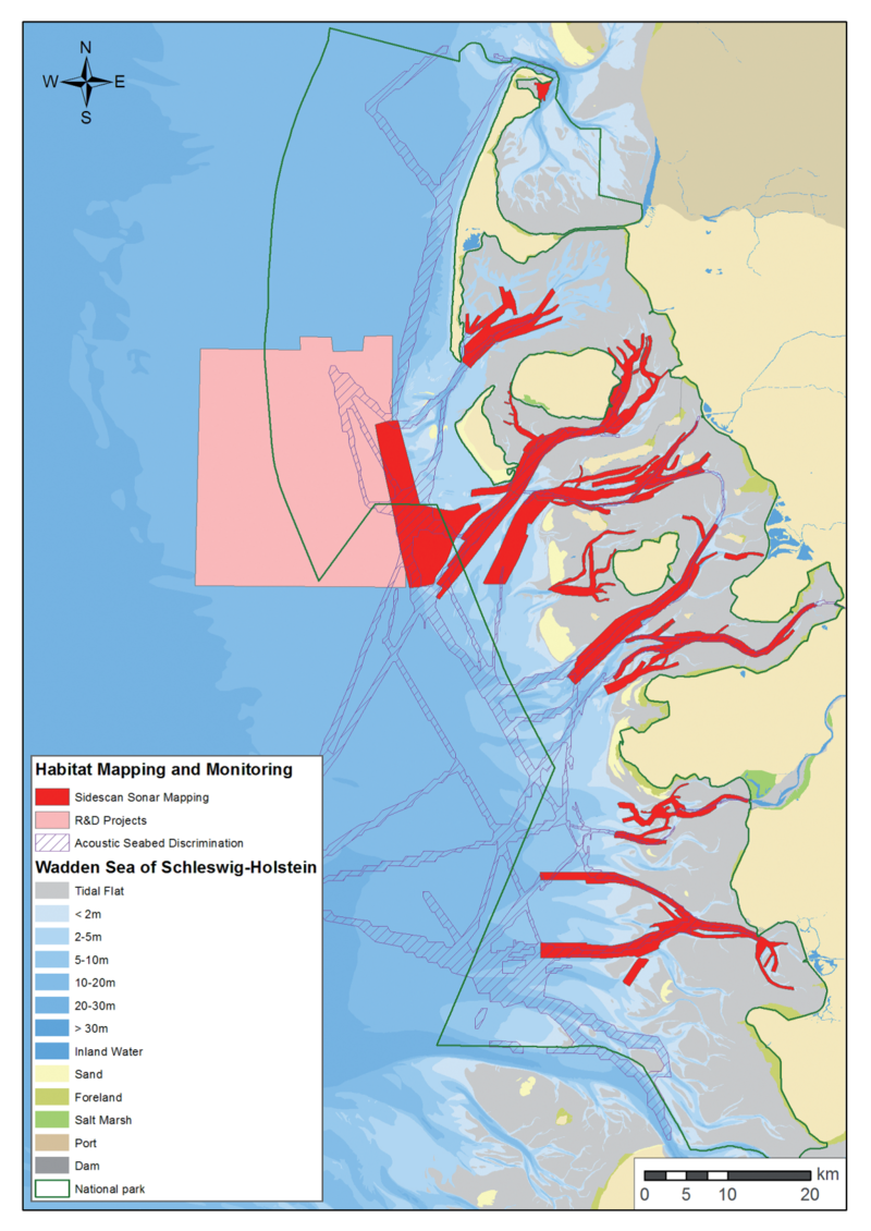
Figure 1. Mapped subtidal areas of the northern German Wadden Sea.
At the beginning of the millennium the knowledge about habitats in the deeper parts of the Wadden Sea was limited as well as the availability of appropriate investigation methods (Vorberg et al., 2009). The requirements of the EU Habitats Directive and the Marine Strategy Framework Directive on one hand and the demand for an ecosystem-based Wadden Sea management on the other hand has led to considerable progress in subtidal habitat mapping of the Wadden Sea. In The Netherlands, research projects provided increasing insight into the dynamics of subtidal wild blue mussel beds (see Annex). Substantial progress was achieved in full-coverage seabed mapping in the subtidal of the German Wadden Sea especially in the Schleswig-Holstein area (Figure 1). For many areas blue mussel Mytylus edulis and Pacific oyster Crassostrea gigas beds, sand mason worm Lanice conchilega aggregations, areas with a high content of detritic shells, peat outcrops, geogenic hardgrounds and outcrops of consolidated sediments have been identified. Additionally, detailed sediment distribution maps have been compiled.
For the identification and definition of habitats the classification scheme of the European Nature Information System EUNIS (Davies et al., 2004) is used. The relevant subtidal habitats of the Wadden Sea are listed under the EUNIS level A4 and A5, including rock and other hard substrate in highly turbid conditions, biogenic constructions like Sabellaria reefs or mussel beds as well as subtidal sediments ranging from boulders and cobbles to coarse, mixed and fine sands. For methods and data used in this report see Annex.
2. Status and Trends
2.1 Blue mussel beds (EUNIS level A4.241/A5.625)
In the Dutch annual blue mussel stock assessment, those areas are sampled where occurrence of Mytilus edulis is expected based on historical data by fishermen and fisheries inspectors. The uppermost panel of Figure 2 shows the occurrence frequency per sampling station, determined for the entire survey period since 1992. Blue mussels are found most often more inland, towards the ‘Afsluitdijk’ that separates the Wadden Sea from Lake Ijssel. The bottom panel of the Figure 2 shows a habitat suitability map for blue mussels, that was created using the spring and autumn survey data as input and the abiotic parameters water depth, median grain size, wave action, current speed and bottom sheer stress (Smaal et al., 2014; Troost et al., 2015). Most suiTable areas are located along the ‘Afsluitdijk’ and Molenrak; probably because these are areas of relatively low salinity resulting in low starfish predation pressure.
Next to the natural subtidal beds there is also a substantial biomass of blue mussels present on culture plots. These mussel culture plots can also be considered subtidal habitats with higher biodiversity than the surrounding sandy areas (Dekker & Drent 2013; Drent & Dekker 2013) although ecological parameters of blue mussel cultures plots are partly different compared to natural mussel beds (Saier 2002; Buschbaum & Nehls 2003; Buschbaum & Saier 2003).
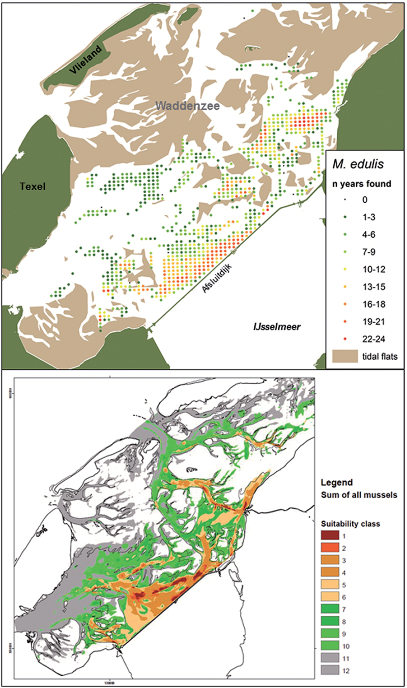
Figure 2. Top: Distribution map of blue mussel Mytilus edulis in the western Dutch Wadden Sea indicating frequency of occurrence per sampling station for stations sampled more than four times, calculated for all years in which the species was recorded in the annual subtidal mussel stock assessment (1992-2015). Mean and maximum densities calculated for all years and all stations were 92.1 m-2 and 11,437.0 m-2, respectively. Bottom: Habitat suitability map for blue mussels based on water depth, median grain size, wave action, current speed and soil shear stress. Suitability class 1 and 12 indicate highest and lowest suitability, respectively.
Apart from mussel culture plots in Germany (about 2000 ha in Schleswig-Holstein and 1300 ha in Lower Saxony) some wild perennial blue mussel beds could be detected in the North Frisian Wadden Sea. However, the knowledge about the development of the size and structure of subtidal habitats is still limited. Dredge sampling campaigns reveal that in different subtidal areas blue mussels have been abundant for many years (Büttger et al., 2014), but the method does not allow insight in size or structure of the mussel beds. This methodological gap could partly be closed by side scan sonar based monitoring techniques. The hydroacoustic data reveal that size and structure of perennial natural subtidal blue mussel beds can be relatively stable over years (Figure 3). The beds found so far obviously have a stable bank character, although one of the monitored banks was completely buried by sand dunes due to channel migration. All multi-year blue mussel assemblages that were only found in very shallow water show an intensive association with an increasing population of the Pacific oyster Crassostea gigas. Accordingly, it is rather unlikely that there are subtidal mussel banks in the northern German Wadden Sea, which are composed exclusively of Mytilus edulis.

Figure 3. Mapped subtidal habitats in the North Frisian tidal basins of Norder- and Süderaue. The magnification (top right) shows a sonar mosaic of one of the mussel beds and its spatial variation monitored from 2012 to 2015.
Preliminary information on mussel beds in subtidal areas was collected in Lower Saxony. Most of the identified mussel beds are located in very shallow waters and they seem to be the continuation of intertidal banks towards subtidal areas (Figure 4). Little information is available on subtidal mussel beds in deeper areas, and further surveys are underway for mapping and monitoring purposes.
Monitoring of bivalve stocks in the Danish Wadden Sea stopped in 2009. Thus, the actual status of blue mussel beds is unknown.
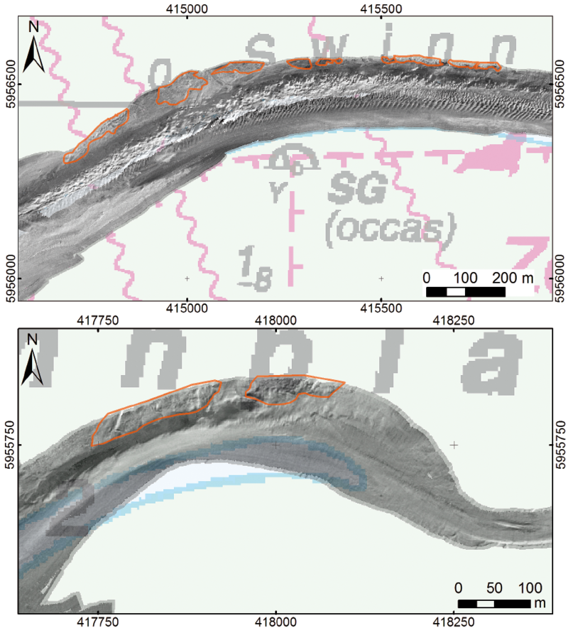
Figure 4. Backscatter images of mussel beds in the transition area from the (northern) intertidal to the subtidal in the Lower Saxony Wadden Sea.
2.2 Pacific oyster beds (EUNIS level A5.643)
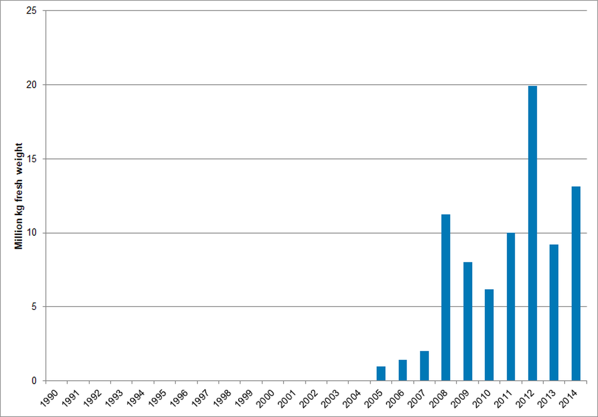
The Dutch blue mussel stock assessment survey entirely covers the subtidal distribution area of Pacific oysters in the western Dutch Wadden Sea (Figure 5). Pacific oysters co-occur with blue mussels making biomass estimates reliable. The reef-forming Pacific oyster first occurred in the dataset in 2005 and showed a strong increase in 2008. Since then the oyster biomass is fluctuating around a virtually stable value (Figure 6).
In Denmark, no monitoring of bivalve stocks has been carried out since 2008 but personal comments from local fishermen and NGOs indicate that the Pacific oyster is spreading in the area. A permit for “test-fishery” of Pacific oysters was initiated in 2015 to investigate if a cost-efficient fishery could be established to be beneficial for the fishery and at the same time combat the invasive Pacific oyster. After only a few days of fishing the results showed that due to the reef-structure of the Pacific oysters the fishery was not cost-efficient and, therefore, the fishery was stopped (pers. comm. SP. Jensen, The Danish Agrifish Agency).
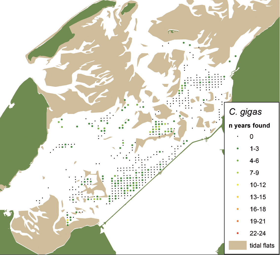 Figure 5. Distribution map of the Pacific oyster Crassostrea gigas in the subtidal western Dutch Wadden Sea indicating frequency of occurrence per sampling station for stations sampled more than four times, calculated for all years in which the species was recorded in the annual subtidal mussel stock assessment (2003-2015). Mean and maximum densities calculated for all years and all stations were 0.3 m-2 and 84.2 m-2, respectively.
Figure 6. Annual biomass stock of the Pacific oyster Crassostrea gigas in the subtidal western Dutch Wadden Sea (Marsdiep and Vliestroom tidal basins; the smaller Eierlandsegat tidal basin is not monitored).
2.3 Lanice conchilega beds (EUNIS level A5.137)
Investigations in the northern part of the German Wadden Sea showed numerous patches of dense aggregations of the sand mason worm (Lanice conchilega, Figure 7). The areas where this tube-building polychaete are mainly found are characterized by fine to medium sandy sediments with a high content of shell fragments and a comparatively high current velocity. Lanice beds are variably shaped and reach some square meters up to several hectares in extent and some centimetres up to one meter in height (Vorberg et al., 2009). The biogenic structures are known to be rather unstable and the occurrence of Lanice beds in the Wadden Sea is probably highly underestimated. An assessment of status and trends is hardly possible with traditional sampling methods. In contrast to that, hydroacoustic surveys deliver reliable data (Degraer et al., 2008; Ricklefs & Arp 2011), because the bed surface gives a characteristic backscatter signal (Figure 8).
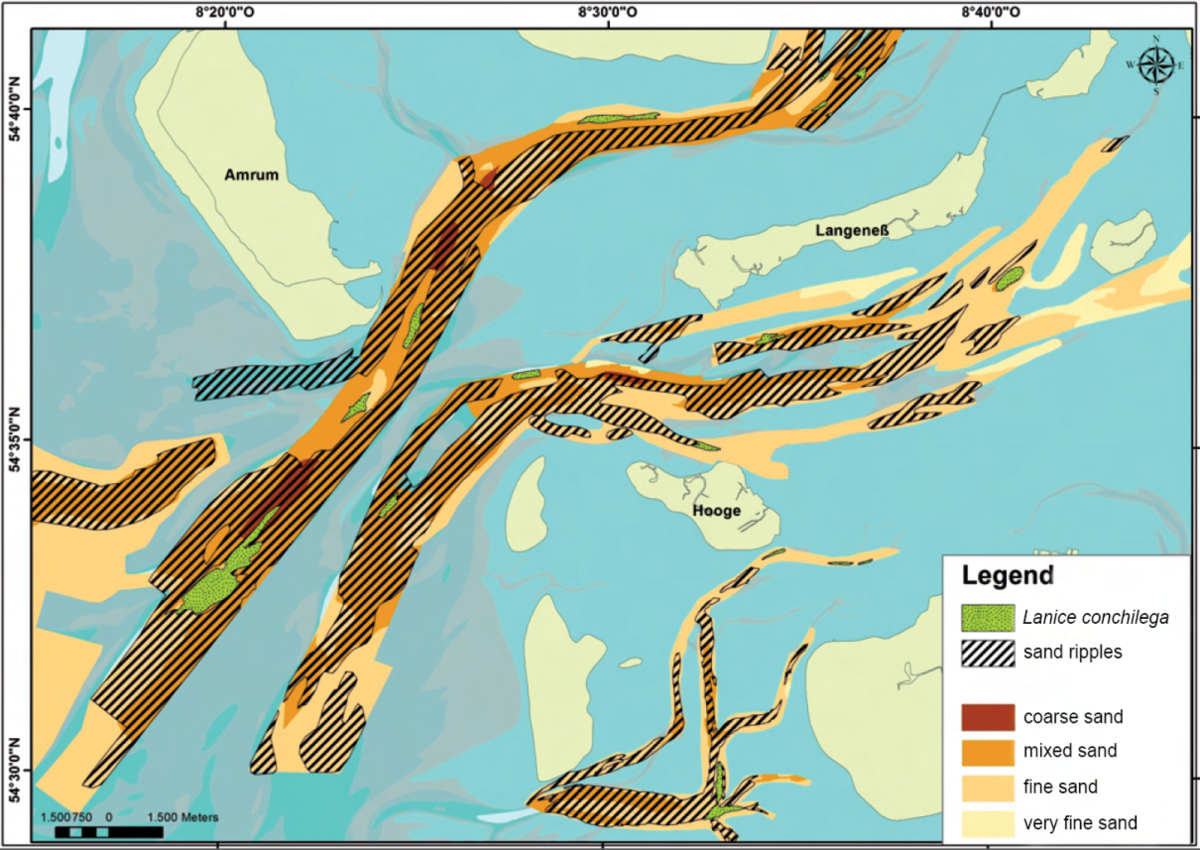 Figure 7. Results from hydroacoustic surveys in the subtidal of the northern German Wadden Sea: Lanice conchilega beds (green) on sandy bottom. Sand ripples (black dashed lines) indicate high water current velocities.
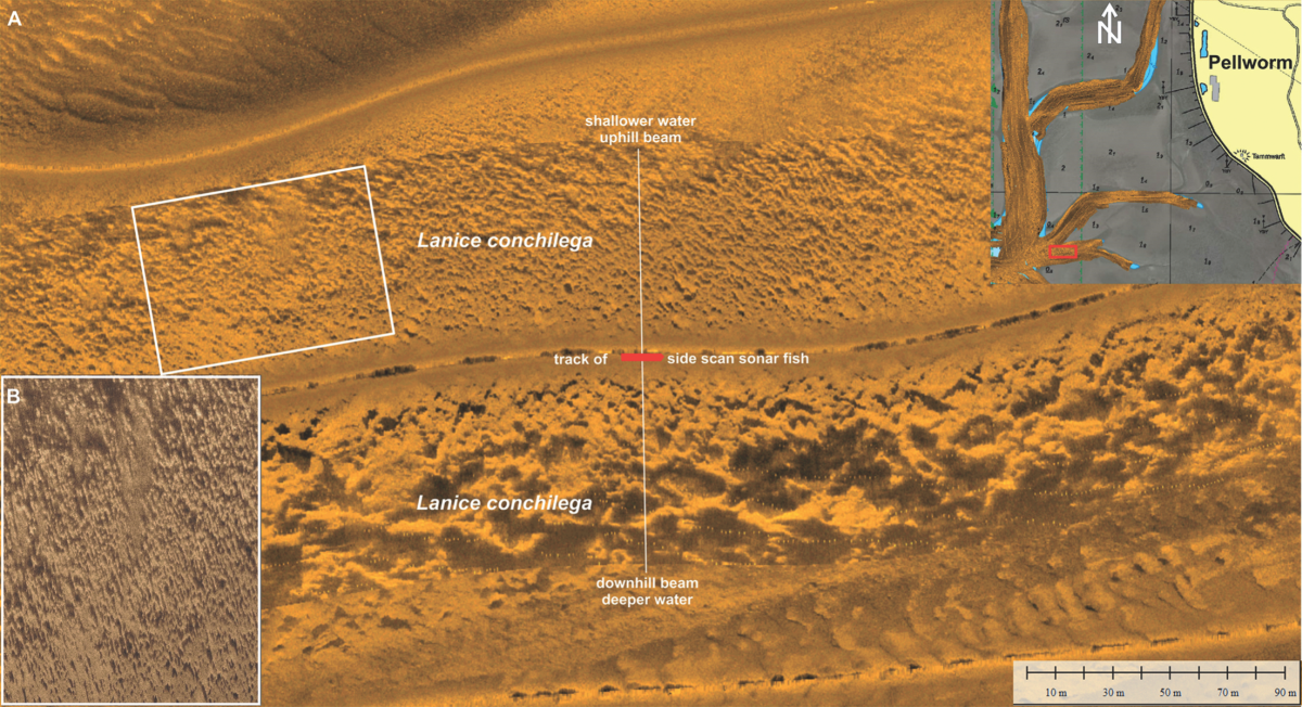 Figure 8. Side scan sonar mosaic showing different acoustic patterns of a Lanice conchilega bed in the North Frisian Wadden Sea near the island of Pellworm (A). The magnification (B) indicates the raw sonar recording (geometrically not corrected) displaying single individuals of L. conchilega.
2.4 Coarse, medium and fine sand (EUNIS level A5.2)
The European Marine Observation and Data Network (EMODnet 2015) has published a draft version of habitat maps of the Greater North Sea including the Wadden Sea area. According to these maps extended areas in the subtidal show sandy sediments (Figure 9) representing by far the most common habitat in the Wadden Sea. This habitat type suits the EUNIS classification A5.2, whereas the distinction of sandy sediments from the habitat type "sandbank" as described in the EU Habitats Directive (code 1110, Annex I) is often unclear.
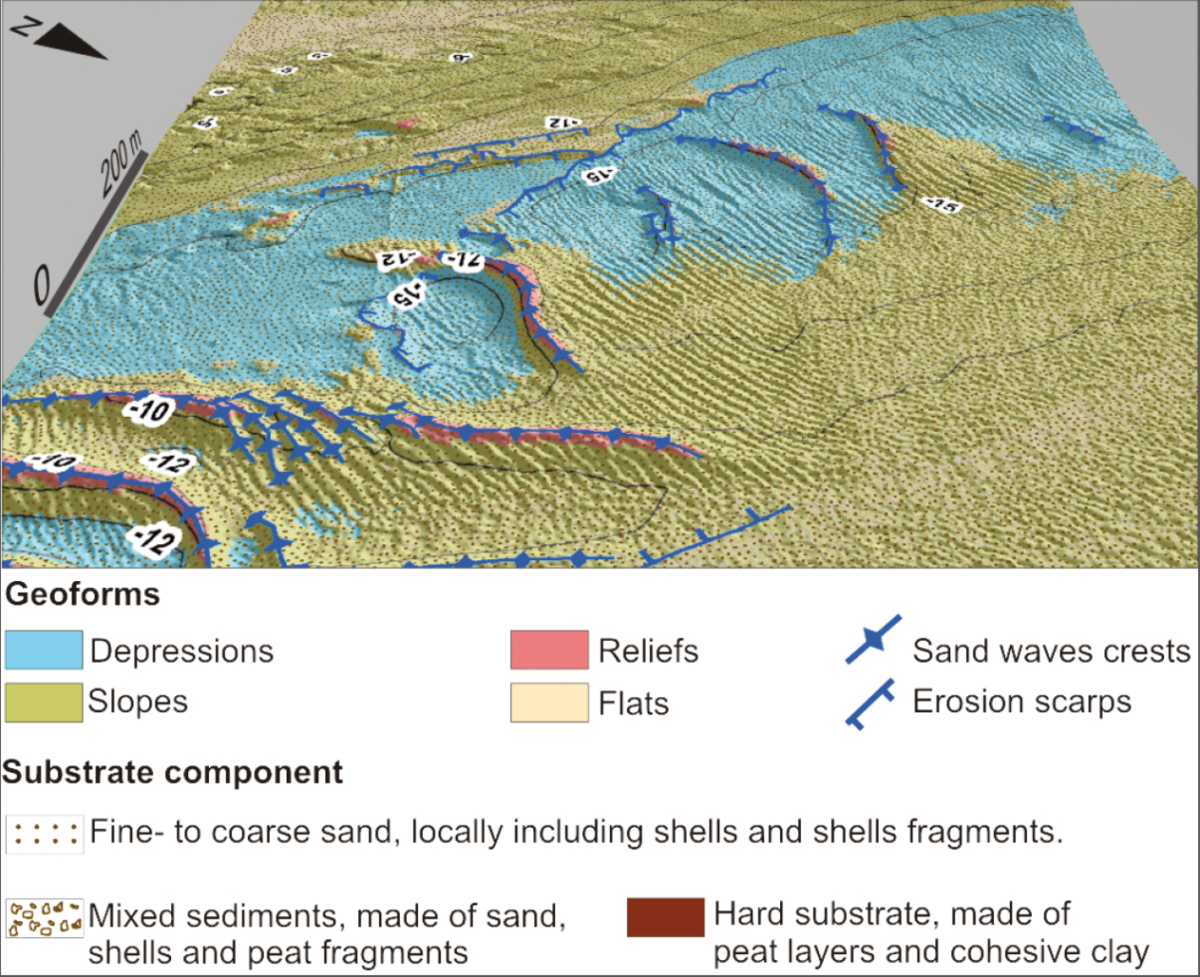
A systematic sediment mapping with a higher spatial resolution is carried out in the German Wadden Sea. The nature of the seabed is mainly characterized by sandy sediments, mostly consisting of fine and medium sand (Figures 7 and 9); coarser fractions can also be present, mixed with sand and generally made of shells and shell fragments. Mainly biogenic sediments are locally present, made of a high concentration of detritic shells. Sandy seabeds are generally characterized by very intensive morphodynamics driven by tides and waves, which results in the wide presence of depositional bedforms as small to large sand waves along the tidal channels. They are characterized by a height ranging from about 0.1 up to 4 m and a wave length from 0.6 to 100 m. A compound superimposition of smaller sand waves on the biggest ones is present, outlining morphodynamic processes of different intensities, shaping the seabed at different temporal and spatial scales (Figure 10).
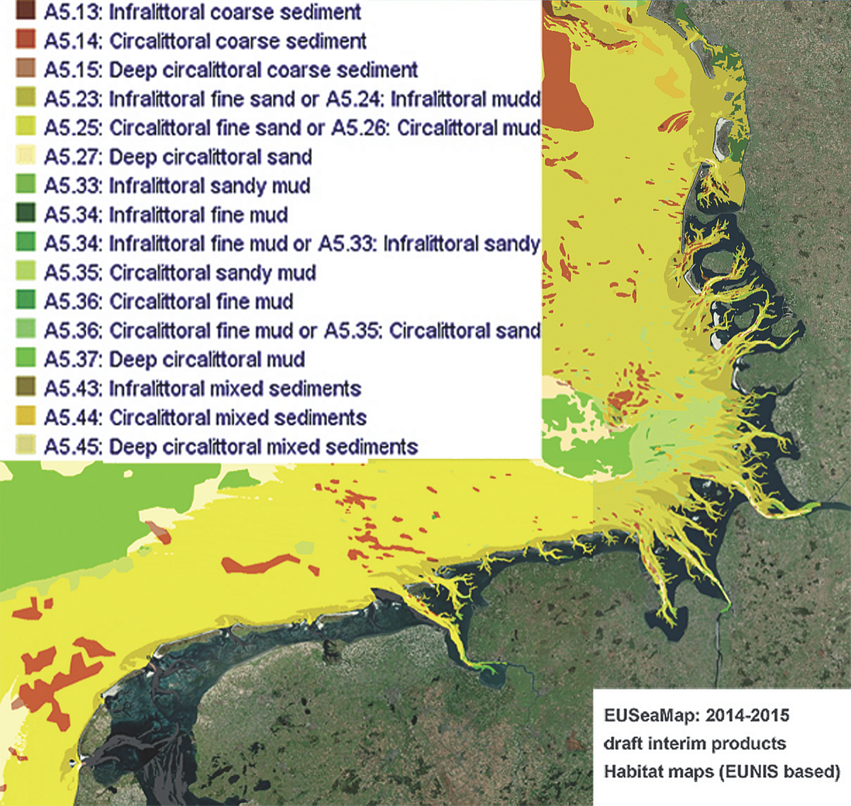 Figure 9. Habitat map of the Wadden Sea and adjacent offshore areas based on EUNIS classification (after EMODnet 2015).
Figure 10. Map of geoforms and substrate nature of an inlet in the West Frisian Wadden Sea. Geoforms include morphological zones, as well as depositional and erosive bedforms (classification according to Madden & Grossman 2007). Nomenclature of substrate nature is according to EUNIS classification (modified after Mascioli et al., 2017).
2.5 Muddy sand (EUNIS level A5.241)
The occurrence of Ensis ssp. is characteristic for "slightly muddy fine sand" at the lower shore and the shallow subtidal. In the Dutch Wadden Sea the Atlantic jack knife clam (Ensis directus) is mostly found in the deeper water of the gullies subjected to higher current velocities (Figure 11). Results of the short-term “Zee- en Kust Onderzoek” (ZKO) monitoring project (NWO, 2016) and of the additional monitoring within the “Mosselzaad-Invanginstallaties” (MZI) project (Kamermans et al., 2014) show, that substantial parts of the distribution area of this species are missed in the annual mussel stock survey. E. directus may also be expected to occur in the subtidal of the eastern Dutch Wadden Sea where adequate monitoring of macrobenthos is lacking. In the Wadden Sea of Schleswig-Holstein, Ensis is mainly found in fine sands but partly in medium sand as well. The knife clam was also sampled in areas with pronounced sediment dynamics visible in clear bed forms like ripples or underwater dunes.
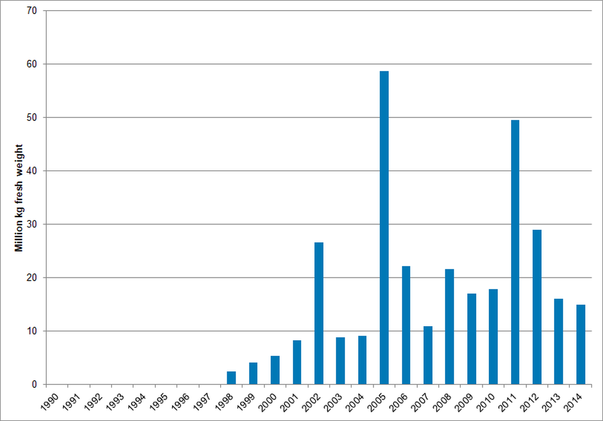
The stock size of the deep-burrowing E. directus might be underestimated, because the sampling technique is designed for epifaunal and shallow burrowing shellfish species. To estimate the percentage by which the stock size of E. directus is underestimated, comparative sampling has been carried out in the Dutch Wadden Sea in 2015, in which the bottom dredge used in the annual mussel stock assessment was compared to a hydraulic grab. These measurements will be continued in 2016. The razor clam first occurred in the dataset in 1998 and the biomass show a clear increase in the first years (Figure 11). Apart from the peaks in 2005 and 2011 the stock size is more or less stable since 2002 indicating that habitats of muddy sand do not alter in this area.
Figure 11. Top: Distribution map of Ensis directus in the subtidal western Dutch Wadden Sea indicating frequency of occurrence per sampling station for stations sampled more than four times, calculated for all years in which the species was recorded in the annual subtidal mussel stock assessment (1993-2015). Mean and maximum densities calculated for all years and all stations were 13.4 m-2 and 3.8 m-2, respectively. Bottom: Annual biomass stock of Ensis directus in the subtidal western Dutch Wadden Sea (Marsdiep and Vliestroom tidal basins; the smaller Eierlandsegat tidal basin is not monitored).
2.6 Reefs and hard substrate (EUNIS level A4)
The most famous and undoubted example of a biogenic reef in the subtidal of the Wadden Sea is the reef-like construction of the polychaete Sabellaria spinulosa. The last proofs of Sabellaria reefs are from the early 1990s, since then no Sabellaria reefs have been detected (Vorberg, 1997, 2005).
Biogenic and geogenic reefs, which totally fulfil the requirements defined in the interpretation manual of EU Habitats (EC, 2007) are rarely found in the subtidal of the Wadden Sea. From four subtidal blue mussel banks mapped in 2015 in the North Frisian Wadden Sea (Figure 3) only two can be classified as biogenic reefs.
Hard substrates, such as till outcrops, areas covered with gravel and stones, peat as well as outcrops of consolidated cohesive sediments were found in different parts of the subtidal in the Wadden Sea. From a morphological point of view till, peat, and outcrops of consolidated cohesive sediments are clearly morphologically distinct to the surrounding unconsolidated sand by breaks of slope bounding steep sloping surfaces (Figure 12), shaped by erosive processes. On the other hand, areas covered with gravel and stones often cannot be unambiguously distinguished from the surrounding seafloor. From a habitat point of view, all these hard substrates are considered ecologically important for the Wadden Sea. It is well known that e.g., stones are important as settling ground for numerous epibenthic species or that consolidated fine grained sediments are bored by piddocks and colonized by anthozoa at the surface. Clear definitions are needed for origin, size and shape of reefs and hard substrate in order to assess habitats for nature conservation purposes.
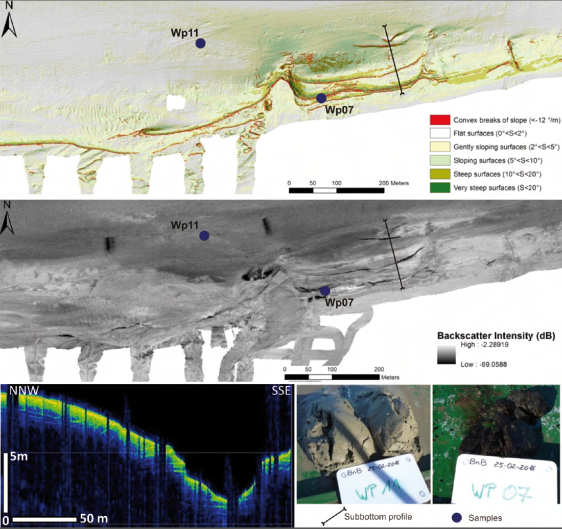 Figure 12. Identification of hard bottom substrates from morphological analysis (top; greenish coloured areas), backscatter intensities (centre), sub-bottom profiles (bottom left) and ground-truthing (bottom right).
3. Assessment
Targets of the Wadden Sea Plan with respect to subtidal habitats are:
- A natural dynamic situation;
- An increased area of geomorphologically and biologically undisturbed subtidal areas;
- An increased area of, and a more natural distribution and development of natural mussel beds and Sabellaria reefs.
For a long time, the permanently submerged part of the Wadden Sea was an unknown area of several thousand square kilometres. The lack of knowledge leads to general and vague formulations of targets given in the trilateral Wadden Sea Plan. An evaluation of the targets assumes that there is an extensive knowledge and a broad database on subtidal habitats of both the historical and present situation. This is not the case and hence an evaluation of terms like "natural dynamics", "increased area" or “natural development” is currently not possible.
The progress in full-coverage seabed mapping will result in an increasing data collection and thus enhanced knowledge on occurrence, distribution and size of different habitats and their species inventory. This will provide the basis for reviewing the targets with respect to a quantifiable approach. The setting of targets based on measurable parameters is the precondition of monitoring, research and potential management measures.
4. Recommendations
4.1 Recommendations for management
- Establishing a commonly accepted understanding and definition of the term ‘habitat’ including a comprehensive list of Wadden Sea habitats;
- Review of targets: Instead of general and qualitative postulations as formulated in the Wadden Sea Plan revised targets should meet the requirements of the Marine Strategy Framework Directive of measurable targets and associated indicators that allow for monitoring and assessment;
- Installation of a trilateral expert group for subtidal habitat mapping;
- Support by CWSS for the installation of a trilateral expert group.
4.2 Recommendations for monitoring and research
- Full-coverage approach for subtidal habitat mapping;
- Development of an integrated hydro-acoustic survey combining multibeam and side scan sonar technology for full-coverage mapping and underwater video for ground truthing;
- Development of integrated methods and sampling gear to detect species that play a key role in Wadden Sea ecology, e.g., habitat forming species;
- Harmonization and equilibration of internationally established state-of-art methods applied for habitat mapping;
- Regular workshops for joint analyses and assessment of data.
5. Summary
Effort and methodology of mapping the subtidal zone of the Wadden Sea were differently pronounced in Denmark, Germany and The Netherlands. Generally, the activities show an increase in quality and quantity over the last six years.
In recent years, the Danish Wadden Sea was not in the focus of national research and development programs. Compared to the status described in the Quality Status Report 2009 no new information could be gained. However, the continuation of monitoring work by the national research institute DTU Aqua promises new insights for the future.
In The Netherlands subtidal habitat mapping focusses mainly on blue mussel and Pacific oyster beds. Although other macrobenthic species such as the bivalve species Mya arenaria and Ensis directus were also recorded, a structural monitoring is needed in addition to the annual mussel survey in the western Wadden Sea and should be extended to the subtidal zone of the eastern Dutch Wadden Sea. It is therefore recommended to set up a basic monitoring program covering the entire subtidal area over important environmental gradients, which determine species composition, such as sediment type, seabed morphology and current velocity. Methods and sampling gear used should be suiTable to detect species that play a key role in the ecosystem, e.g., habitat forming species.
Great progress in subtidal habitat mapping was made in the German Wadden Sea, where full-coverage mapping of extended areas could be performed. The consistent use of remote sensing methods, such as side scan sonar and multibeam echosounding resulted in habitat maps indicating the existence of Lanice beds and of natural subtidal blue mussel beds. Besides sedimentological and biological features the assessment of bedforms and geomorphological processes was implemented as a significant part of habitat mapping. Although the EU Habitats Directive does not consider bedforms at local- and meso-scale, they represent a very important indicator of morphodynamical processes (Madden & Grossman, 2007).
It becomes more and more apparent, that sandy sediment is the by far dominating habitat type in the subtidal of the Wadden Sea area. Highly dynamic natural processes lead to permanent changes of this habitat type with respect to water depth, grain size distribution and seabed morphology (see report geomorphology). These unstable and changing environmental conditions result in a relatively poor biodiversity in this area. Accordingly, subtidal sandy habitats are of less relevance for nature conservation purposes. Future challenge will be to discover biodiversity-hotspots, which include biogenic structures, such as mussel beds, Sabellaria reefs and Lanice beds, as well as geogenic formations which provide hard substrates for settling of epibenthic species. These habitats are of great importance for the ecology of the Wadden Sea and subject to protection and management measures. For that, we require a common understanding and clear definitions of the relevant habitats, given that in Germany blue mussel beds or loose collections of stones on the seabed are regarded as reef (code 1170, Annex I of the EU Habitats Directive), whereas in The Netherlands code 1170 is not at all distinguished, but included in 'sandbanks' (code 1110).
About the authorsR. Vorberg1, S. Glorius2, F. Mascioli3, P. Nielsen4, H.-C. Reimers5, K. Ricklefs6, K. Troost7 1 Marine Science Service, Fasanenstieg 12, 21521 Dassendorf, Germany 2 Wageningen Marine Research, Research Institute, Ankerpark 27, 1781AG Den Helder, The Netherlands 3 Coastal Research Station, NLWKN Norden-Norderney, An der Mühle 5, 26548 Norderney, Germany 4 Technical University of Denmark, Danish Shellfish Centre, Kemitorvet, 2800 Kgs. Lyngby, Denmark 5 Landesamt für Landwirtschaft, Umwelt und ländliche Räume, Flintbek, Hamburger Chaussee 25, 24220 Flintbek, Germany 6 Research and Technology Centre Westcoast of Kiel University, Hafentörn 1, 25761 Büsum, Germany 7 Wageningen Marine Research, Regional Centre Yerseke, Korringaweg 7, 4401NT Yerseke, The Netherlands |
References
Bartholomä, A., P. Holler, K. Schrottke & A. Kubicki (2011) Acoustic habitat mapping in the German Wadden Sea – Comparison of hydro-acoustic devices. Journal of Coastal Research, 64: 1-5
Buschbaum, C. & G. Nehls (2003) Effekte der Miesmuschel- und Garnelenfischerei. In: Lozán, J., Rachor, E., Reise, K., Sündermann, J. & von Westernhagen, H. Warnsignale aus Nordsee & Wattenmeer. Wissenschaftliche Auswertungen, Hamburg, 242-247.
Buschbaum, C. & B. Saier (2003) Biodiversität und nachhaltige Nutzung - Ballungszentrum Muschelbank. Biologie in unserer Zeit 33(2): 100-106.
Büttger, H., G. Nehls & P. Stoddard (2014) The history of intertidal blue mussel beds in the North Frisian Wadden Sea in the 20th century: can we define conditions for conservation targets by analyzing aerial photographs? Journal of Sea Research 87:91–102.
Capperucci, R.M., W. Adolph, D. Hodapp, R. Jung, A. Schmidt, P. Holler, A. Bartholomä, M. Ehlers, U. Sörgel, H. Hillebrand & H. Farke (2013) From 630 km to the ground: a new multiscale approach to scientific habitat monitoring of intertidal and subtidal areas. GEOHAB 2013, International Conference on Marine Geological and Biological Habitat Mapping, 6-10 May 2013, Rome
Dankers, N. & F. Fey-Hofstede (2015) Een zee van Mosselen. Handboek ecologie, bescherming, beleid en beheer van mosselbanken in de Waddenzee. Lisse, pp. 108
Darwin, C. (1859) On the Origin of Species by Means of Natural Selection (6th Edition). John Murray, London.
Davies, C. E., D. Moss & M. O. Hill (2004) EUNIS habitat classification revised 2004. EEA-Report, 310 pp.
Degraer, S., G. Moerkerke, M. Rabaut, G. van Hoey, I. du Four, M. Vincx, J.-P. Henriet & V. van Lancker (2008) Very-high resolution side scan sonar mapping of biogenic reefs of the tube-worm Lanice conchilega. Remote Sensing of Environment 112(8): 3323-3328.
Dekker, R. (1989) The macrozoobenthos of the subtidal western Dutch Wadden Sea. I. Biomass and species richness. Netherlands Journal of Sea Research, 23: 57-68
Dekker, R. & J. Drent (2013) The marcozoobenthos in the subtidal of the Western Dutch Wadden Sea in 2008 and in comparison with 1981 – 1982. NIOZ-Report 2013-5, 98 pp.
Drent, J. & R. Dekker (2013) How different are subtidal Mytilus edulis L. communities of natural mussel beds and mussel culture plots in the western Dutch Wadden Sea? NIOZ-Report 2013-6, 94 pp.
EC (2007) Interpretation manual of European Union Habitats. European Commission. DG Environment. Nature and biodiversity: 142 S.
EMODnet (2015) Seabed habitats. http://www.emodnet-seabedhabitats.eu/default.aspx?page=1974&LAYERS=SubstrateCeltNorthBaltic,HabitatsNorthCelt2015&zoom=8&Y=53.43413786782225&X=5.597534178911135
Fey-Hofstede, F.E., N.M.A.J. Dankers, A. Meijboom, P. W. van Leeuwen, J. Cuperus, B. E. van der Weide, M. de Jong, E. M. Dijkman & J. S. M. Cremer (2014) Ecologische ontwikkeling binnen een voor menselijke activiteiten gesloten gebied in de Nederlandse Waddenzee. Wot-technical report 34, IMARES report C041/15, 42 pp.
Glorius, S., A. Rippen, M. de Jong, B. van der Weide, J. Cuperus, A. Bakker & M. Hoppe (2014) De ontwikkeling van niet beviste sublitorale mosselbanken 2009 – 2013. IMARES-rapport C109/14
Ismail, K., V. A. I. Huvenne & D. G. Masson (2015) Objective automated classification technique for marine landscape mapping in submarine canyons. Marine Geology, 326: 17-32
Jasiewicz, J., Z. Zwoliński, H. Mitasova & T. Hengel (eds.) (2015) Geomorphometry for geosciences. – Adam Mickiewicz University in Poznań – Institute of Geoecology and Geoinformation, International Society of Geomorphometry, 278 pp.
Kamermans, P., C. Smit, J. Wijsman, A. Smaal (2014) Meerjarige effect – en productiemetingen aan MZI’s in de Westelijke Waddenzee, Oosterschelde en Voordelta: samenvattend eindrapport. Imares Wageningen UR, Rapport C191/13. 93 pp
Kostylev, V. E., B. J. Todd, G. B. J. Fader, R. C. Courtney, G. D. M. Cameron & R. A. Pickrill (2001) Benthic habitat mapping on the Scotian Shelf based on multibeam bathymetry, surficial geology and sea floor photographs. Marine Ecology Progress Series, 210: 121–137.
Kristensen, P. S., K. Geitner, P. Sandbeck & R. Borgstrøm (2007) Mapping of exploited Danish bivalve stocks. Contribution to the ICES WGMHM in Woods Hole US, April 2007. ICES Council Meeting MHC:07: 97-91.
Le Bas, T.P. & V. A. I. Huvenne (2009) Acquisition and processing of backscatter data for habitat mapping – comparison of multibeam and side scan systems. Applied Acoustics, 70: 1248-1257.
Lurton, X. & G. Lamarche (eds) (2015) Backscatter measurements by seafloor-mapping sonars. Guidelines and Recommendations. 200 pp. (http://geohab.org/wp-content/uploads/2013/02/BWSG-REPORT-MAY2015.pdf)
Madden, C.J. & D. H. Grossman (2007) A framework for a coastal/marine ecological classification standard (CMECS). – In: TODD, B.J. & GREENE, H.G. (eds.): Mapping the seafloor for habitat characterization. Geological Association of Canada, Special Paper, 47: 185-209.
Mascioli, F., F. J. Gutiérrez, H. Dirks, M. Gutowski & A. Wurpts (2014) Integrated approach for Habitat Mapping in Wadden Sea and North Sea (Lower Saxony, Germany). GeoHab 2014 Conference, Abstract Volume, 67
Mascioli, F., G. Bremm, P. Bruckert, R. Tants, H. Dirks & A. Wurpts (2017) The contribution of geomorphometry to the study of a tidal inlet (Wadden Sea, Germany). Zeitschrift für Geomorphologie, Zeitschrift für Geomorphologie, Supplementary Issues, 61(2): 179-197.
NWO Netherlands Organisation for Scientific Research (2016) Final evaluation of the Dutch National Ocean and Coastal Research Programme (ZKO). 62 pp.
Ricklefs, K. & D. Arp (2011) Identifizierung mariner Lebensraumtypen nach FFH im Schleswig-Holsteinischen Wattenmeer. Abschlussbericht i. A. des LKN S-H: 66 S.
Saier, B. (2002) Subtidal and intertidal mussel beds (Mytilus edulis L.) in the Wadden Sea: diversity differences of associated epifauna. Helgol. Mar Res. 56: 44-50.
Schwarzer, K., S. Themann & R. Krause (2008) Zusammenstellung der marinen Lebensraumtypen nach FFH. - Bericht Inst. f. Geowissenschaften Univ. Kiel, 35 pp.
Smaal, A. C., A. G. Brinkman, T. Schellekens, J. Jansen, A. Agüera & M. R. van Stralen (2014) Ontwikkeling en stabiliteit van sublitorale mosselbanken samenvattend eind rapport. IMARES rapport C066.14, 32 pp.
Stralen van, M., D. van den Ende & K. Troost (2015) Inventarisatie van het sublitorale wilde mosselbestand in de westelijke Waddenzee in het voorjaar van 2015. MarinX rapport 2015, 151 pp.
Troost, K., M. van Stralen, C. van Zweeden & B. Brinkman (2015) Ruimtelijke verspreiding van mosselen en Japanse oesters in de Waddenzee in de periode 1992-2013. IMARES report C062.15.
Valentine, P. C., B. J. Todd & V. E. Kostylev (2005) Classification of marine sublittoral habitats, with application to the northeastern North America region. American Fisheries Society Symposium 41: 183-200.
Vorberg, R. (1995) On the decrease of sabellarian reefs along the German North Sea coast. - Publ. Serv. Géol. Lux. 29: 87-93.
Vorberg, R. (2005) Sabellaria Reefs. In : Essink, K., Dettman, C., Farke, H., Laursen, K., Lüerßen, G., Marencic, H. & Wiersinga, W.: Wadden Sea Quality Status Report 2004. Wadden Sea Ecosystem No. 19. Trilateral Monitoring and Assessment Group, Common Wadden Sea Secretariat, Wilhelmshaven, Germany. 208-210.
Vorberg, R., F. Fey, & J. Jansen (2009) Subtidal habitats. In: Marencic, H. & J. de Vlas (eds.). 2009. Quality Status Report 2009. WaddenSea Ecosystem No. 25. Common Wadden Sea Secretariat, Trilateral Monitoring and Assessment Group, Wilhelmshaven, Germany
Wunderlich, J., & S. Müller (2003) High-resolution sub-bottom profiling using parametric acoustics. International Ocean Systems, 7(4): 6-11
This report should be cited as: Vorberg R., Glorius S., Mascioli F., Nielsen P., Reimers H.-C., Ricklefs K. & Troost K. (2017) Subtidal habitats. In: Wadden Sea Quality Status Report 2017. Eds.: Kloepper S. et al., Common Wadden Sea Secretariat, Wilhelmshaven, Germany. Last updated 21.12.2017. Downloaded DD.MM.YYYY. qsr.waddensea-worldheritage.org/reports/subtidal-habitats

