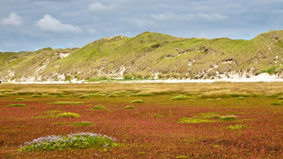
Photo: Martin Stock / LKN-SH. Green beach on the island of Amrum.
Salt marshes
P. Esselink, W.E. van Duin, J. Bunje, J. Cremer, E.O. Folmer, J. Frikke, M. Glahn, A.V. de Groot, N. Hecker, U. Hellwig, K. Jensen, P. Körber, J. Petersen, M. Stock
PDF1. Introduction
Coastal salt marshes may broadly be defined as areas, vegetated by herbs, grasses or low shrubs, which are subject to periodic flooding (tidal and non-tidal) as a result of fluctuations in the level of the adjacent saline-water bodies (Adam, 1990), and where saline water is defined as not being fresh, i.e. when the annual average salinity is greater than 0.5 g of solutes per kg of water (Odum, 1988). In tidal systems, salt marshes form the upper part of the intertidal zone, i.e. the interface between land and sea. They may extend vertically from well below the mean high-tide level up to the highest water mark. Salt marshes reach their greatest extent along low-energy coasts where wave action is limited and mud can accumulate (Allen & Pye, 1992; Balke et al., 2016).
According to the EU Habitat Directive, salt marshes include the habitat types 1310 (Salicornia and other annuals colonising mud and sand), 1320 (Spartina swards), and 1330 (Atlantic salt meadows), for which national conservation objectives have been elaborated.
The above definition of salt marsh implies that a salt marsh is not defined by its substrate. Although the great majority of European salt marshes have a clayey substrate, the substrate can vary from pure sand to clay and peat.
Various human activities have a direct or indirect impact on salt marshes. These activities include, land use (grazing, artificial drainage, recreation, nature conservation, and coastal defence measures), as well as pollution and eutrophication.
Trilateral policy and management
All salt marshes in the Wadden Sea area are part of Natura 2000 areas. In addition to the national legislation and nature protection regulations in the Netherlands, Germany and Denmark, the trilateral 2010 Wadden Sea Plan (WSP) provides the framework for the management of the entire area (CWSS, 2010). In the WSP, the following five targets have been formulated for salt marshes:
- To maintain the full range of variety of salt marshes typical for the Wadden Sea landscape;
- To achieve an increased area of salt marshes with natural dynamics;
- To achieve an increased natural morphology and dynamics, including natural drainage of mainland salt marshes, under the condition that the present surface area is not reduced;
- To maintain a salt marsh vegetation diversity reflecting the geomorphological conditions of the habitat with variation in vegetation structure;
- To maintain or to achieve favourable conditions for all typical species.
Contents
In order to assess the above-mentioned targets, this report will review the following topics:
- Trends and present status of the Wadden Sea salt marshes including their total extent, distribution, geomorphology, vegetation composition and management on the basis of the TMAP monitoring programme;
- Potential threats including consequences of loss of diversity by vegetation succession (Esselink et al., 2009), and sea-level rise due to climate change;
- Ecological restoration of salt marshes.
2. Status and trends
2.1 Total area
Based on the most recent data, salt marshes in the Wadden Sea extend over virtually 40,000 ha, (Table 1). The size of the Wadden Sea salt marshes represents about 20 % of the total area of coastal salt marshes in Europe (Doody, 2008). Although the extent of salt marshes in the Wadden Sea is considerable, it is worth to note that they have been much more extensive in the past than they are today (Wiersma et al., 2009; Vos & Knol, 2015). The major cause for their decline during historical times has been land-claim to acquire new land for agriculture, and more recently, coastal-protection measures. Loss of salt marsh through human intervention continued throughout the twentieth century.
From a morphological view, four types of salt marsh may be distinguished in the Wadden Sea, viz. (Figure 1): (A) back-barrier marshes, (B) foreland marshes, (C) Hallig salt marshes, and (D) green beaches. The reported extent of salt marshes in this report is not based on geomorphology, but on vegetation and habitat mapping (Petersen et al., 2014).
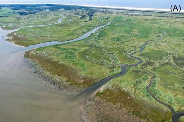
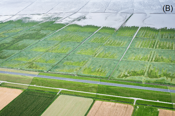
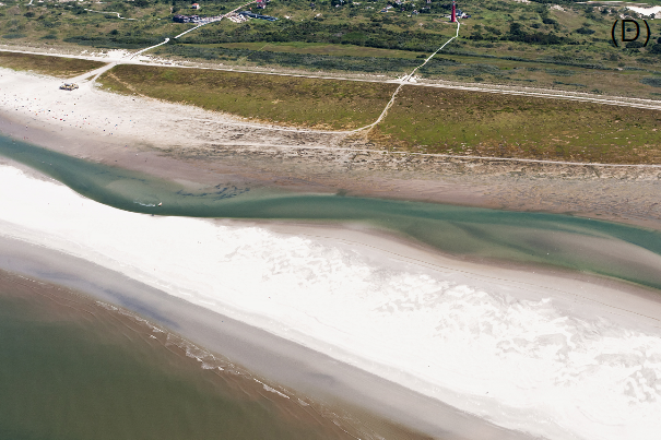
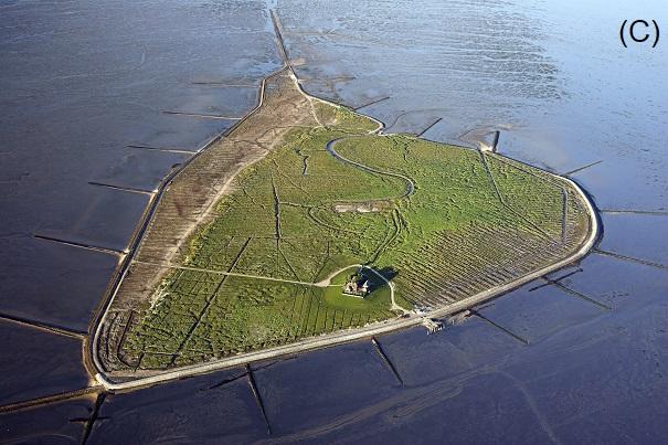 Figure 1. Photographic impression of the four characteristic salt marsh types of the Wadden Sea. Clockwise, starting from the upper left: (A) barrier-connected salt marsh in the lee of a dune ridge, (B) clayey foreland-type salt marsh mostly found on the mainland and largely man-made, (C) hallig salt marsh that developed on a remnant part of the historic mainland, and which are not protected by a seawall, and (D) green beach in the seaward area of a dune ridge (Photos: Martin Stock / LKN-SH (lower right), Rijkswaterstaat (others)).
Green beaches may develop in the seaward area of a dune ridge (see Figure 1 in “Beaches and dunes”). From a vegetation perspective, green beaches cannot be considered entirely as salt marsh, because mostly they form a mosaic of salt marsh and dune vegetation. Therefore, at the landscape level, they are a transition between the beach, the dune system, and salt marshes. Since green beaches are not distinguished as landform, halophytic vegetation of green beaches was merged with back-barrier marshes into one group, viz.: barrier-connected salt marshes (see Table 1).
Barrier-connected salt marshes are in principal natural marshes. They developed in the lee of a barrier or dune system. The construction of artificial dune ridges in the past has stimulated the development of back-barrier salt marshes, such as the Boschplaat salt marsh on Terschelling (NL), and the salt marsh of the Skallingen peninsula (DK). The presence of extensive artificial dune ridges explain why in the Netherlands Wadden Sea the extent of barrier-connected marshes today is much larger than their historic reference values (Dijkema 1987). On some German islands, such as Norderney and Juist, parts of the barrier-connected salt marshes have been artificially drained. A side effect of both the artificial ridges and the draining is that natural dynamics are reduced, and vegetation succession is accelerated (Esselink et al., 2009; de Groot et al., 2016).
Foreland salt marshes on the mainland make up approximately half of the salt marsh area in the Wadden Sea. These salt marshes are largely of anthropogenic origin, because their development has been promoted by the construction of sedimentation fields and ditching. Despite their artificial origin, the foreland salt marshes are appreciated for their value for nature conservation. Natural foreland salt marshes are relatively rare.
A Hallig is a salt marsh island, which has been part of the mainland and which is not protected by a seawall. Hallig salt marshes thus accreted on low-lying old land. They show a greater resemblance with the clayey foreland salt marshes than with the sandy barrier-connected salt marshes. Hallig salt marshes are generally protected by revetments (Figure 1).
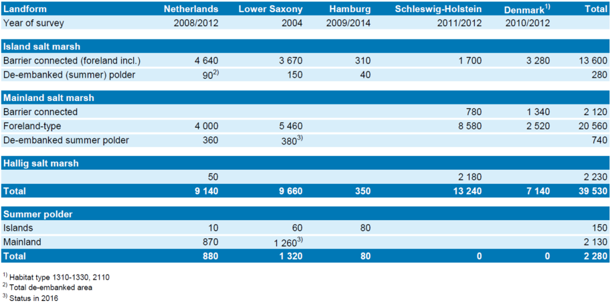
Summer polders have a risk to be flooded by seawater during extreme storm tides, but mostly with only a minor effect on the vegetation. Strictly speaking, and contradictory to the WSP, most summer polders cannot be considered as salt marsh, because flooding by seawater is too infrequent. Consequently, the area of halophytic vegetation in summer polders is very limited. Because summer polders have a high potential for salt marsh restoration, their 2,280 ha were added as an extra category to Table 1.
Table 1. Recent extent (ha) of salt marshes and summer polders in different parts of the Wadden Sea classified by their geomorphology. On the islands, de-embanked summer polders may be added to the barrier-connected marshes; on the mainland to the foreland-type salt marshes.
2.2 Salt marsh distribution and trends
The distribution of the salt marshes shows some conspicuous variation across the Wadden Sea (Figure 2). Barrier-connected salt marshes on the mainland coast are restricted to the northern part of the Wadden Sea. Hallig salt marshes are almost restricted to Schleswig-Holstein, with the Punt van Reide salt marsh in the Netherlands, as an exception.
 Figure 2. Overview of the total area of salt marshes and summer polders in different parts of the Wadden Sea specified according to their morphology. NL = the Netherlands, LS = Lower Saxony, HH = Hamburg, SH = Schleswig-Holstein, DK = Denmark. Same data as Table 1.
After a reported 1,600 ha increase of salt marsh in the previous QSR (Esselink et al., 2009), based on most recent surveys, salt marshes showed an almost Wadden Sea wide continued expansion (Figure 3). Because new survey data was not yet available for Lower Saxony, a complete net change of area could not be calculated. In the four remaining sectors, however, the total extent increased by more than 2,600 ha since the 2002/2007 survey, and more than 3,750 ha since the 1995/2001 survey. About three-quarter of the last-named increase was caused by the (barrier-connected) island salt marshes which expanded by over 40 %. This increase showed considerable spatial variation. The salt marsh of Schiermonnikoog, for instance, increased by about 500 ha between the two most recent surveys, which equalled to 67 % of the total increase of islands salt marshes in the Dutch area in this period. The island salt marshes of Lower Saxony matched the overall trend with an upward change between the 1995/2001 and 2002/2007 surveys (Figure 3; Esselink et al., 2009).
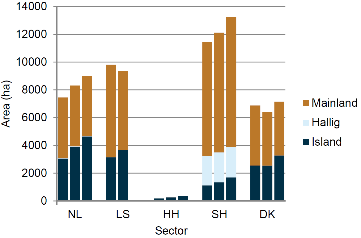 Figure 3. Development of the areal extent of salt marshes in different parts of the Wadden Sea based on three successive surveys; from left to right: 1995/2001, 2002/2007 and 2008/2014. Data of the first two surveys are from Esselink et al. (2009) with a downward correction for the exclusion of dune vegetation of green beaches.
The general trend of the island salt marshes differs clearly from the development of both mainland and Hallig salt marshes (Figure 3). Hallig salt marshes are almost completely enclosed by revetments (Figure 1), and their size therefore remained almost unchanged with a total extent of 2,230 ha (Table 1). Mainland marshes showed different trends among sectors. In the Netherlands and Denmark, overall net changes were negligible, whereas expansion of mainland marshes continued in Schleswig-Holstein during the last survey, and since 2001, these marshes increased in size by 1,160 ha.
2.3 Salt marsh zones and vegetation composition
In the 2009 QSR, ageing of salt marshes, i.e. the extension of late-succession salt marsh communities, mostly with low species diversity, at the expense of young succession stages, was identified as the dominant process in most salt marshes. This development results in an increased incidence of late-succession vegetation types, especially vegetation of Elytrigia atherica (Esselink et al., 2009; Bakker 2014; Rupprecht et al., 2015). The observed recent development of new salt marsh did not result in a similar increase of pioneer and low-marsh vegetation types (Figure 4). On the contrary, the extent of pioneer and low-marsh vegetation types remained relatively constant during the most recent vegetation survey compared to the two previous surveys, which can only be explained by a continued succession (Figure 4).
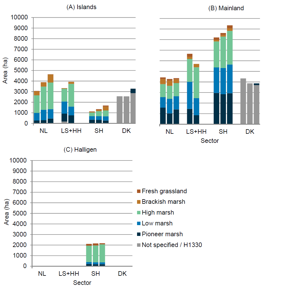 Figure 4. Development of the areal extent of the different vegetation zones based on three successive salt marsh surveys: 1995/2001, 2002/07 and 2008/2014 (from left to right) on the Wadden Sea (A) Islands, (B) Mainland and (C) Halligen. Data of the 1995/2001 survey from Bakker et al. (2005); 2002/2007 from Esselink et al. (2009). For graphical reasons, the salt marshes of Hamburg have been pooled with Lower Saxony, despite missing data for Lower Saxony in 2008/2014; Hallig-type salt marshes in the Netherlands have been included in the mainland marshes. The pioneer zone is defined as the area where pioneer vegetation covers ≥5 % (Petersen et al., 2014); in Schleswig-Holstein this threshold value is 10 %.
Based on the most recent available figures, Table II.1 (Annex II) gives the vegetation composition of the Wadden Sea salt marshes per site or region and per sector according to the TMAP vegetation typology, except for Denmark where vegetation was mapped in less detail at the level of EU habitats, Table II.2, (Annex II). At the habitat level, vegetation types of the low to brackish-marsh zones are all merged into habitat H1330 (Petersen et al., 2014). This means that the succession stage of Danish salt marshes cannot be assessed from the currently available maps.
In the other sectors, the E. atherica vegetation (TMAP code S.3.7) was generally the dominant type in the high-marsh zone, whereas the late-succession Phragmites australis vegetation (TMAP code S.5.2) of the brackish marsh zone had only a modest incidence, except at some specific sites. When the incidence of E. atherica and P. australis vegetation are added up, late-succession stages extent over one-third or more of the area in several larger salt marsh sites Table II.1 (Annex II).
In the mainland salt marshes of the Netherlands, the extent of high-marsh vegetation remained relatively constant (Figure 4B). The largest parts of these marshes are grazed, which here restrains the succession from low-marsh to high-marsh vegetation (Esselink et al., 2009).
In the framework of salt marsh engineering, Spartina anglica was introduced and planted at several sites in the Wadden Sea from 1925 onwards (van Eerde, 1942; Esselink, 1998; Reise, 1994). Meanwhile the species is the dominant and characteristic species of the S. anglica vegetation type in the TMAP vegetation typology (Petersen et al., 2014) and of habitat H1320 (Spartina swards; Doody, 2008). S. anglica vegetation can be found in almost every salt marsh of the Wadden Sea (Annex II), and in this sense, the introduction of the species meant a great change in the Wadden Sea salt marshes. There are only a few salt marshes, however, where S. anglica vegetation covers considerable areas and reaches an incidence of about 20 % (with an outlier of almost 40 % value on the island of Mandø, Denmark (Annex II). The species is not only a pioneer on bare mudflats, but it may be found also in depressions at higher surface elevation with an impeded drainage. This may explain the relatively high incidence of S. anglica vegetation in some of the mainland marshes, where the upkeep of artificial drainage has been abandoned, such as in salt marshes of Groningen (NL), and of both Dithmarschen and Nord-Friesland in Schleswig-Holstein.
2.4 Relative size of salt marshes in relation to tidal basin
Salt marshes form the uppermost part of the intertidal zone, and hence they can also be considered as the most upward part of a tidal basin. In order to analyse the spatial distribution of salt marshes from a geomorphological point of view, this section presents the extent of salt marshes in the Wadden Sea relative to the size of the tidal basin or tidal area.
The Wadden Sea comprises 33 tidal basins (CWSS et al., 2008). A digital map of these basins in GIS was not available in time, however. Instead, the map of Meltofte et al. (1994) was used and adapted with a subdivision of the Wadden Sea into 23 tidal areas (Figure 5). The term tidal area should be read here between inverted commas, because it was not feasible to exclude all supratidal areas and areas protected by seawalls and dunes, especially on the islands.
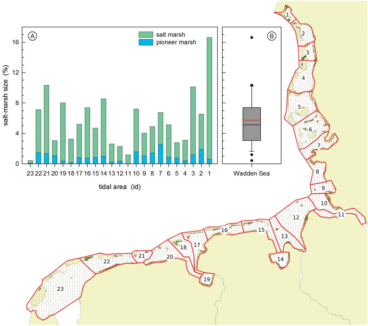 Figure 5. Distribution of salt marshes in the Wadden Sea. (A) The size of pioneer marsh and total salt marsh as a percentage of the tidal area. (B) Boxplot of the relative salt marsh size per tidal area in the Wadden Sea with median and 25 and 75 percentiles (grey). The mean is indicated by the red line. The subdivision of the Wadden Sea into tidal areas has been adapted from Meltofte et al. (1994).
Salt marshes, on average, made up almost 6 % of the tidal area (Figure 5B). The harmonic mean (i.e. weighed for the size of the tidal areas) was considerably lower and amounted 4.2 %. These values are well below the 10 % reference value proposed by Dijkema (1987). In the Wadden Sea, salt marshes nowadays vary in size from less than 0.5 % of the tidal area in the most western part up to almost 17 % in the Ho Bugt, Denmark (Figure 5A). Both areas have a similar tidal range of about 1.5 m, which is markedly lower than in the more central parts of the Wadden Sea. The low incidence of salt marshes in the western Wadden Sea may be attributed to large-scale embankments during the last centuries and the closure of the Zuiderzee in 1932 (Dijkema, 1987). Up north in the Ho Bugt, human intervention on the contrary probably enhanced salt marsh expansion by the construction of a sand dike on the Skallingen peninsula in 1933.
A low incidence of pioneer marsh may indicate in which tidal basins salt marshes probably retreat or where pioneer marsh is squeezed between succession of the salt marsh and lower-lying mud flat. Salt marshes in the Dollard bay (tidal area no. 19), for instance, are slowly declining (Esselink et al., 2011), and this area has one of lowest incidences of pioneer marsh.
The seaward salt marsh edge extends further down on the vertical gradient with an increase of the tidal range (Balke et al., 2016). Hence, the tidal range may potentially influence the salt marsh size positively.
The position of salt marshes is thus related to the prevailing geomorphological and hydrological conditions in a tidal basin. From this point of view, it appears a logical step to analyse the status and trends of salt marshes based on the properties of tidal basins. At this stage, however, such an analysis was not feasible, because this would first require a further harmonization of the existing spatial data.
2.5 Salt marsh works
Over 50 % of the current salt marshes in the Wadden Sea are formed by foreland-type salt marshes on the mainland (Table 1, Figure 2). These mainland marshes have to a great extent been developed within salt marsh works. In general, management aims have shifted during the last quarter of the last century from agricultural exploitation and land claim to nature conservation. This shift led to a change in management that varied from a general minimum intervention to a strategic upkeep of parts of both the drainage and the groyne system. As a result, the scenery of the marshes today still reminds of a historical-cultural landscape by the imprints from the past, such as the geometric pattern of the marshes, remnants of extensive artificial drainage networks and the brushwood groynes. In order to enhance naturalness, various restoration experiments have been carried out during the past decades, such as filling up parts of the drainage system, and removing the top soil.
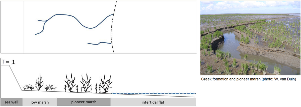
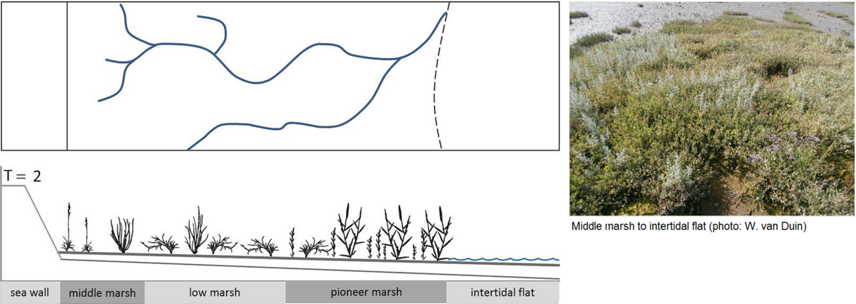
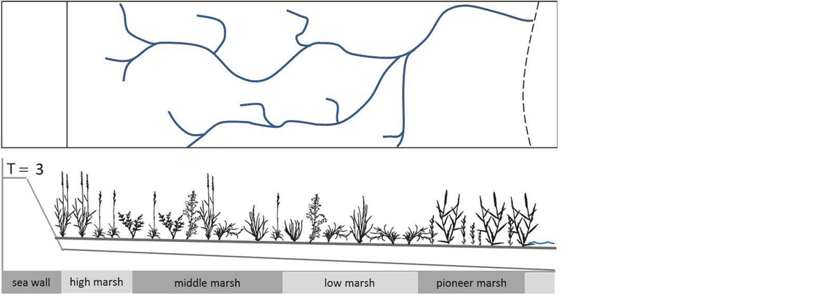
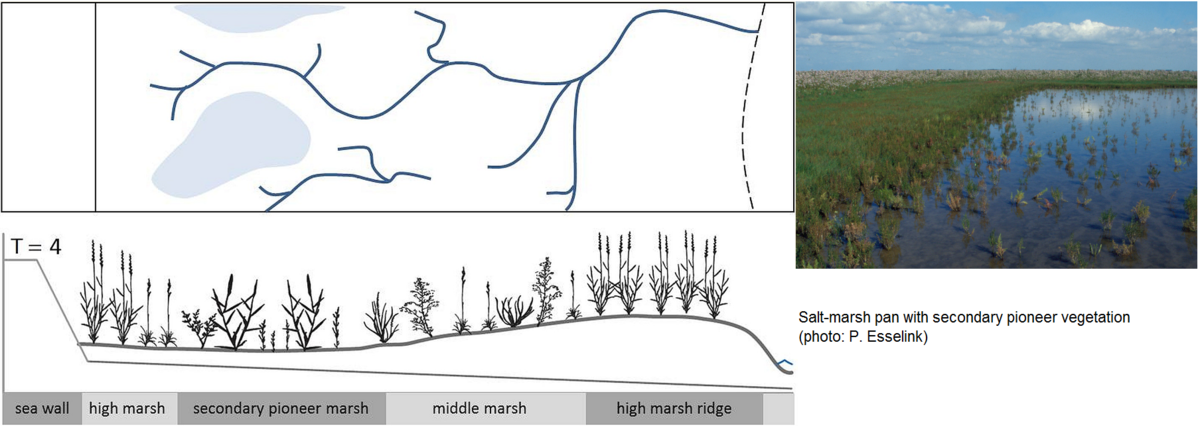
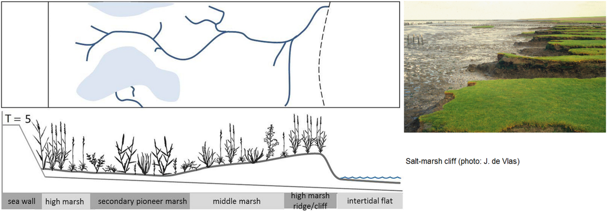
Figure 6. Conceptual model of the development of a mainland salt marsh, and creek development (after van Wesenbeeck et al., 2014). Broken line is mean high tide.
T = 1 Convex mudflat profile with pioneer salt marsh (Salicornia procumbens and Spartina anglica), and developing first creeks;
T = 2 Development of different vegetation zones with e.g. Puccinellia maritima, Aster tripolium, and incision of creeks in the lower parts;
T = 3 Fully developed salt marsh with little profile, and further expanding creek system.
T = 4 Basin and levee system with secondary pioneer marsh, development of poorly drained parts because of collapsing creek sides or silting up of creeks, and development of high marsh ridge;
T = 5 Erosion with cliff formation, and development of new creeks from the poorly drained parts;
T = 6 Sedimentation, and new pioneer marsh and creek formation in front of cliff, and increasing drainage of basins.
In order to assist the decision making in policy and management, and also to evaluate the current status of the mainland foreland salt marshes, a conceptual reference model has recently been constructed for these marshes (Figure 6; van Wesenbeeck et al., 2014). The model takes into account the seawall as an irreplaceable and fixed boundary between the salt marsh and hinterland. Based on six stages of development, the model describes the development of natural foreland salt marshes as a bio-geomorphological succession series (cf. Corenblit et al., 2007). In the first stage (T1) geomorphological processes dominate, creeks are formed, influenced by the topography of the intertidal flats and the presence of establishing pioneer plants (Long & Mason, 1983; Schwarz et al., 2014; Temmerman et al., 2005a, 2007). In stage T2, vegetation increasingly affects creek formation. The water flow is redirected by vegetation clumps, which enhances flow velocity and erosion in the lower parts. On the higher parts concurrently, vegetation cover increases, enhancing the sediment fixation and reinforcing the incision of creeks in the lower parts (Temmerman et al., 2005b, 2007; Kirwan & Murray, 2007). At stage T3, the salt marsh expands onto the intertidal flat, the creeks deepen, and expand by headward erosion (French & Stoddart, 1992; Allen, 2000). With increasing surface elevation of the marsh, the flooding frequency decreases, and the vegetation shifts to late-succession stages, and especially Elytrigia atherica starts spreading (Veeneklaas, 2013). At stage T4, both the filling up of creeks, and the formation of levees of two adjacent creeks may induce poorly drained depressions (Yapp et al., 1917; Townend et al., 2011). Although these depressions may have a high surface elevation, the poor drainage conditions may cause the re-establishment of pioneer vegetation at the expense of late-succession vegetation types. The higher sedimentation in the seaward parts results at some stage (T5) in the formation of a high marsh ridge, and eventually a marsh cliff will develop. Cliff erosion gives space to pioneer vegetation to re-establish (T6), and in this sense may reset marsh succession.
2.6 Artificial drainage of salt marshes
In order to enhance marsh development in the man-made salt marshes, digging and a regular upkeep of the artificial drainage system were traditionally important management practices. The function of artificial drainage was to (1) enhance vegetation establishment high on the intertidal flats, (2) increase the carrying capacity for livestock grazing and (3) prevent the formation of depressions. As an effect of drainage measures, the lower fringe of both pioneer and low-marsh zone could descend vertically by 0.2 metre (Dijkema et al., 1991; Bakker et al., 1997). The upkeep of a dense artificial drainage system generally did not affect vertical accretion rates (Dijkema et al., 1991; Arens & Götting, 2008; Michaelis, 2008).
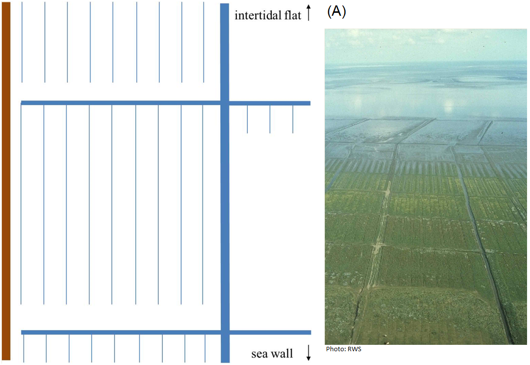
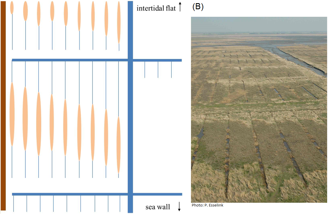
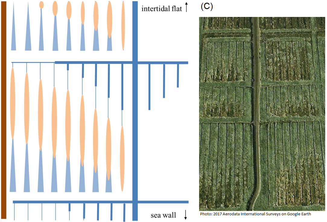
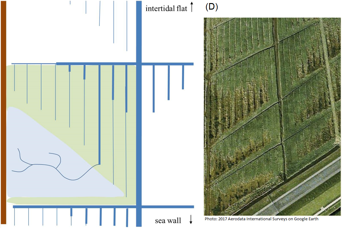
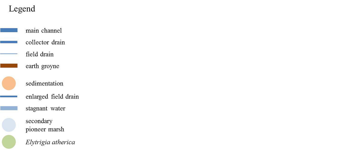
Figure 7. Schematic overview of changes in the artificial drainage system after the traditional maintenance was discontinued. (A) Starting situation. (B) Central parts of the ditches or field drains have silted up. (C) As a consequence, drainage ceases upstream, whereas downstream the field drains deepen and decrease in width. The latter also occurs in the downstream part of the collector drains close to the main channel. (D) The increased soil-waterlogging causes local replacement of vegetation with Elytrigia atherica by secondary pioneer vegetation, and low-marsh vegetation. The photographs show examples from sites in the Netherlands and Germany (modified from van Wesenbeeck et al., 2014).
Parallel with the shift from agricultural exploitation towards the recognition of conservation values of salt marshes, the view on drainage measures has changed dramatically over the last decades. In order to increase the naturalness of man-made salt marshes (Wadden Sea Plan Target), the maintenance of artificial drainage systems has ceased completely over extensive areas. In Germany, this development was stimulated by the foundation of the national parks during the 1980s. A few years earlier, the upkeep of the artificial drainage was stopped already in the larger part of the Netherlands salt marshes in the Dollard (Esselink, 2000). Maintenance of drains in the salt marsh works on the coast of Friesland and Groningen decreased from the 1980s onward, and was stopped completely by 2001 (Dijkema et al., 2001). As a result, the salt marsh is slowly shifting towards a state with increased naturalness, in which elements of the constructed reference model of a natural foreland salt marsh (Figure 6) can be recognized, such as the development of natural creeks in the pioneer zone, build-up of levees, development of poorly drained depressions, and of new creeks in these depressions (Figure 7; van Duin et al., 2016). In the Netherlands, ditching is only continued locally by farmers in order to facilitate livestock grazing. This small-scale practice contributes to the local diversity of the salt marshes.
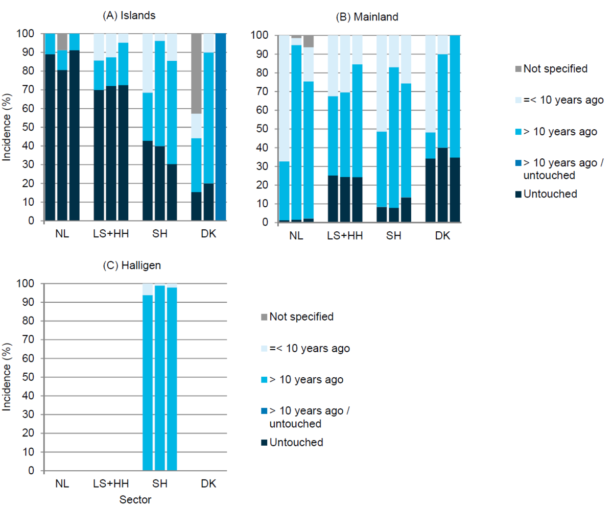 Figure 8. Development of the extent of artificial drainage in the Wadden Sea salt marshes based on three successive salt marsh surveys: 1995/2001, 2002/07 and 2008/2014 (from left to right) on the Wadden Sea (A) Islands, (B) Mainland and (C) Halligen. The graph gives the relative weight of the three drainage classes distinguished: human intervention in the drainage system during the last ten years; last intervention more than ten years ago, and salt marsh not disturbed by artificial drainage. Human intervention may also include restoration measures, especially during the last period. For graphical reasons, salt marshes of Hamburg have been pooled with Lower Saxony; and Hallig-type salt marshes in the Netherlands have been included in the mainland marshes.
Compared to the previous QSR (Esselink et al., 2009), the extent of recent drainage practices basically remained unchanged, except for the mainland marshes in the Netherlands where human intervention in the drainage system increased (Figure 8). Contrary to the past practice, only main channels were refurbished. The most important intervention was, however, the re-profiling of both deeply incised field drains and collector drains to prevent the drowning of livestock (Figure 9). These once-only measures were conducted in the framework of restoration projects that aimed at conserving biodiversity by controlling Elytrigia atherica vegetation by improving the suitability of the marshes for livestock grazing.
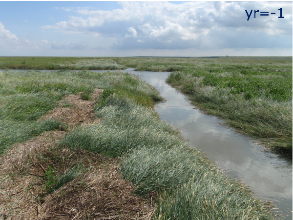
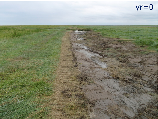
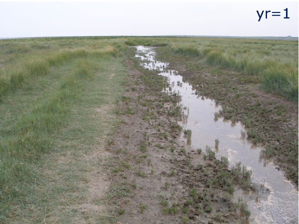
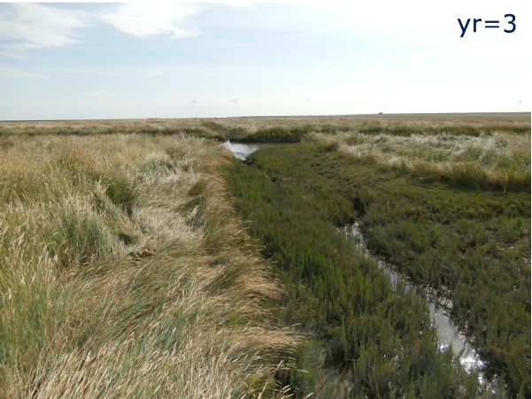 Figure 9. The effect of the partial filling of a collector drain in the salt marsh of Negenboerenpolder, the Netherlands, illustrated by a time series from the year before the filling (yr = -1) until three years thereafter (Photos: W. van Duin).
Especially in Lower Saxony, several projects have been carried out to restore the natural morphology and drainage, of both the back-barrier salt marsh of Norderney (Figure 10) and man-made salt marshes on the mainland. In addition, the percentage area with intervention in the drainage system during the last ten years decreased in Lower Saxony (Figure 8). In Hamburg, the drainage system has not been maintained since the 1950s. Denmark’s drainage activities in salt marshes were cancelled more than ten years ago. Only along the foot of both the Ribe and the Ballum seawall, drains have been dug and are maintained on a regular base.
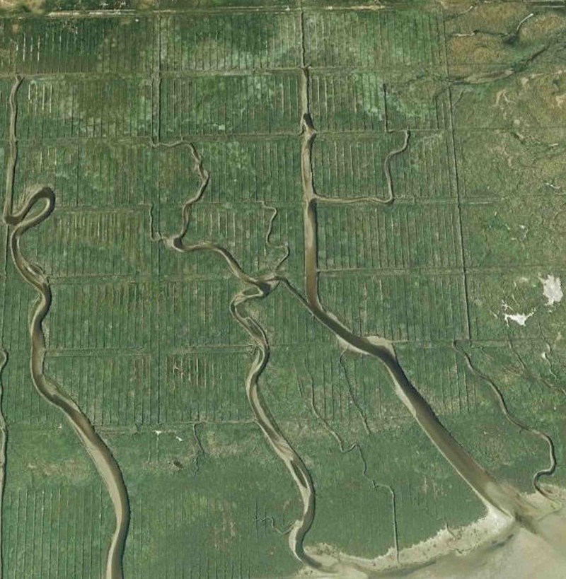
 Figure 10. Restoration of natural drainage in the back-barrier salt marsh on island of Norderney, Lower Saxony. The top soil was removed to decrease the artificial drainage (Linders et al., 2013). Left: situation in 2008 before restoration (Photo: 2017 GeoBasis-DE/BKG on Google Earth), right: situation in 2015 after restoration (Photo: 2017 Earthstar Geographics SIO on Bing Maps by Microsoft)
Documentation on the last time of human intervention in the drainage system was sometimes incomplete. Consequently, the elapsed time thereafter could not always be assessed accurately. In addition, the monitoring does not give any information about the actual status of the drainage system, which can be seen as point for improvement.
2.7 Vegetation management
During the last decades of the 20th century, there has been a major shift in land use of salt marshes in the Wadden Sea from agricultural use to nature conservation. Similar to the previous QSRs, the respective areas of both land-use types were not quantified in the most recent survey. In principle, within both land-use types, management practices such as livestock grazing, mowing, and fallow or minimum intervention may be distinguished. These practices have been assessed in the TMAP surveys.
The shift towards nature conservation largely happened before the start of the trilateral monitoring and assessment programme (Esselink et al., 2009). This explains to a great extent why the status of vegetation management has been relatively constant in the Netherlands and German sectors since the first TMAP survey of 1995/2001 (Figure 9). For example, only about a decade earlier in 1986 (before the foundation of the national park) only 3 % of the mainland salt marshes in Schleswig Holstein had a management of minimum intervention, and 90 % was used for high-intensity livestock grazing. These figures are in sharp contrast with the situation fifteen years later, when minimum intervention extended over 38 % of these marshes, and the area of high-intensity grazing had dropped to less than 50 % (Figure 11).
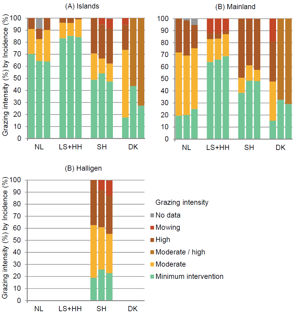 Figure 11. Vegetation management in the Wadden Sea salt marshes during a 20-year period based on three successive surveys: 1995/2001, 2002/07 and 2008/2014 (from left to right) on the Wadden Sea (A) Islands, (B) Mainland and (C) Halligen. Livestock grazing includes both agricultural exploitation and livestock grazing as management tool for nature conservation. For graphical reasons, salt marshes of Hamburg have been pooled with Lower Saxony, and Hallig-type salt marshes in the Netherlands with the mainland marshes.
In Denmark, survey methods differed and varied from livestock counting from the air during the first survey to assessment of the grazing status through fieldwork for the EU habitat surveys more recently (see Annex I). Data may therefore not be fully comparable. In the Danish sector, the area with minimum-intervention management seemed to have doubled on both the island and mainland marshes.
During the surveys, grazing has been subdivided in two classes of intensity which have been defined on the basis of the vegetation structure (Bakker et al., 2005):
- ‘intensive grazing’ is indicated by a uniform short sward,
- ‘moderate grazing’ is indicated by a heterogeneous sward with short and tall canopies.
Moderate or low-intensity grazing permits selective grazing by the grazing animals, and this may induce structural diversity of grazing lawns at preferred sites in one part, and tall stands which are lightly grazed or remain untouched in another part within the same grazing unit. The extent of grazing management should therefore be assessed on the level of grazing units. However, this has not been harmonized yet, and methods may vary among sectors.
At the trilateral level, different views in relation to the management aims existed on the necessity of vegetation management in salt marshes (Bakker et al., 1997; Stock, 1997), but gradually a communis opinio seems to have developed. The fundamental principle of management for nature conservation differs among countries. In the German national parks, the undisturbed course of natural processes is the declared prime objective. This implies a management of minimum intervention. In the Netherlands and Denmark, objectives of management for nature conservation are more centred on the preservation of biodiversity. In order to halt vegetation succession, livestock grazing is advocated in these countries, especially in the semi-natural foreland salt marshes. Now, many researchers have reached a common view and argue for large-scale mosaics of different management regimes to conserve a habitat-specific vegetation and species diversity (de Vlas et al., 2013; Nolte, 2014; Wanner et al., 2014; van Klink, 2014; Stock & Maier, 2016; van Klink et al., 2016).
2.8 Surface-elevation change and sea-level rise
Coastal salt marshes deliver important ecosystem services while at the same time being potentially vulnerable ecoystems in response to global warming and the concomitant sea-level rise (SLR) (Bakker et al., 2016; Kirwan et al., 2016; Crosby et al., 2016). In order to evaluate the status of the Wadden Sea salt marshes in relation to both the current SLR and, an expected accelerated future SLR, an inventory of published and unpublished accretion studies in Wadden Sea salt marshes was carried out. For salt marshes, the level of mean high tide (MHT) is more important than mean sea level. Therefore, the increase of MHT was used as parameter for SLR. Over the last century, increase of MHT varied within the Wadden Sea due to differences in both vertical land movement and changes in wind climate. Since 1900, increase of MHT in the Wadden Sea has been in the order of 2.0–3.0 mm/yr with highest values in the German sector east of the Elbe (Wahl et al., 2011; Jensen et al., 2014). More recently, higher increase rates have been reported for some tide gauges over shorter periods, but these do not differ significantly from fluctuations in the past (Jensen et al., 2014; see also Baart et al., 2012).
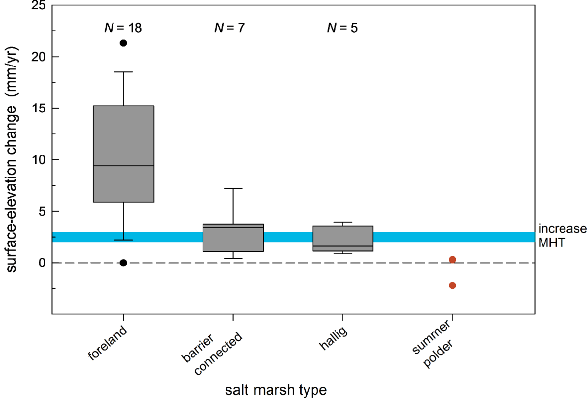 Figure 12. Vertical accretion rates in Wadden Sea salt marshes and summer polders. The graph is a compilation of both changes in surface elevation from levelling studies and accretion data from studies which used Sedimentation-Erosion-Bar (SEB) and marker-horizon techniques including clay-layer thickness measurements (Nolte et al., 2013). Elevation changes are based on overlapping and varying periods in time, mostly starting around 1990 or a more recent date. The graph presents a boxplot with median and 25 and 75 percentiles (grey). The vertical lines give the minimum and maximum values or 1.5 times the interquartile range of the data. Black dots show outliers. The horizontal blue bar gives the range of the long-term increase of MHT level since about 1900 (see text).
Most accretion studies are of relatively recent date, and in order to compare surface-elevation changes (SEC) from comparable periods, data from before about 1990 were disregarded. The survey yielded data from 30 different salt marsh sites, and two summer polders (Annex III).
SECs clearly differ among different types of salt marsh in the Wadden Sea (Figure 12; Stock, 2011). The highest SECs were found in foreland salt marshes with on average three times higher values than in back-barrier marshes (9.6 mm/yr versus 3.2 mm/yr; Figure 12). A SEC rate in the same range as the increase rate of MHT, as was found in the barrier-connected salt marshes, doesnot automatically imply that a salt marsh has a low resilience to SLR (Kirwan et al., 2016). Salt marshes feature a feedback mechanism between surface elevation in the tidal frame, inundation frequency and sedimentation which results in increased sedimentation rates at lower elevation. Furthermore, salt marshes may respond spatially (Kirwan et al., 2016; Figure 4A). The capacity of barrier-connected marshes to keep pace with a significant higher than the current SLR will nevertheless be limited.
Hallig salt marshes show on average the lowest SEC (2.2 mm/yr), which is lower than the local increase of MHT (see above). The Hallig marshes are largely formed by high salt marsh (Figure 4C), which indicates a low flooding frequency, and hence a low potential for sediment import. Hallig salt marshes are mostly surrounded by raised revetments or constructed low banks. These structures impede the flooding of these marshes, and also curtail the import of sediment on to these marshes. Consequently, they represent probably a significant factor for the modest SEC in the Hallig salt marshes (Schindler et al., 2014).
Flooding frequency of summer polders is very limited (mostly less than once a year), due to the height of the enclosing banks. Not surprisingly, the few data available shows that SEC is negligible in summer polders (Figure 12). The example of salt marsh restoration by de-embankment of a summer polder in Noord-Friesland Buitendijks illustrates how the accretion process may successfully be restored: whereas existing summer polders did not keep pace with SLR, increase of surface elevation in the restored salt marsh exceeded SLR with more than 300 % (Figure 13; Esselink et al., 2015).
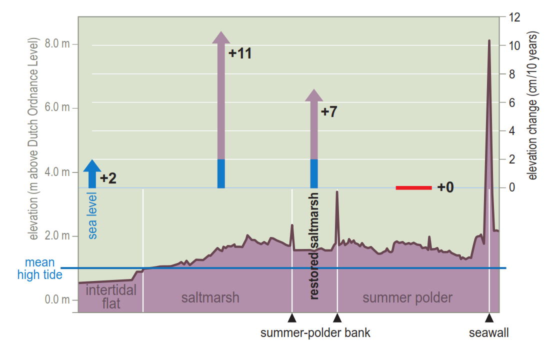 Figure 13. Cross section of the foreland in Noord-Friesland Buitendijks (NL), from the intertidal flat to the main seawall with sea-level and surface-elevation changes in the different parts of the during the first 10 years after the de-embankment of a summer polder (restored salt marsh) (from Esselink et al., 2015).
2.9 Salt marsh restoration by coastal realignment
Over the past centuries, land claim for mainly agriculture and coastal-defence measures resulted in the loss of extensive areas of salt marshes. This process continued far into the twentieth century. Especially on the mainland, embankment rates in the Wadden Sea by far exceeded the development of new salt marsh, despite the artificial enhancement by salt marsh works (Dijkema, 1987). Consequently, the size of the current mainland salt marshes is much smaller in comparison with any historic reference (Dijkema, 1987). This development caused a call for salt marsh restoration in the Wadden Sea (e.g., Frederiksen & Dahl, 1994).
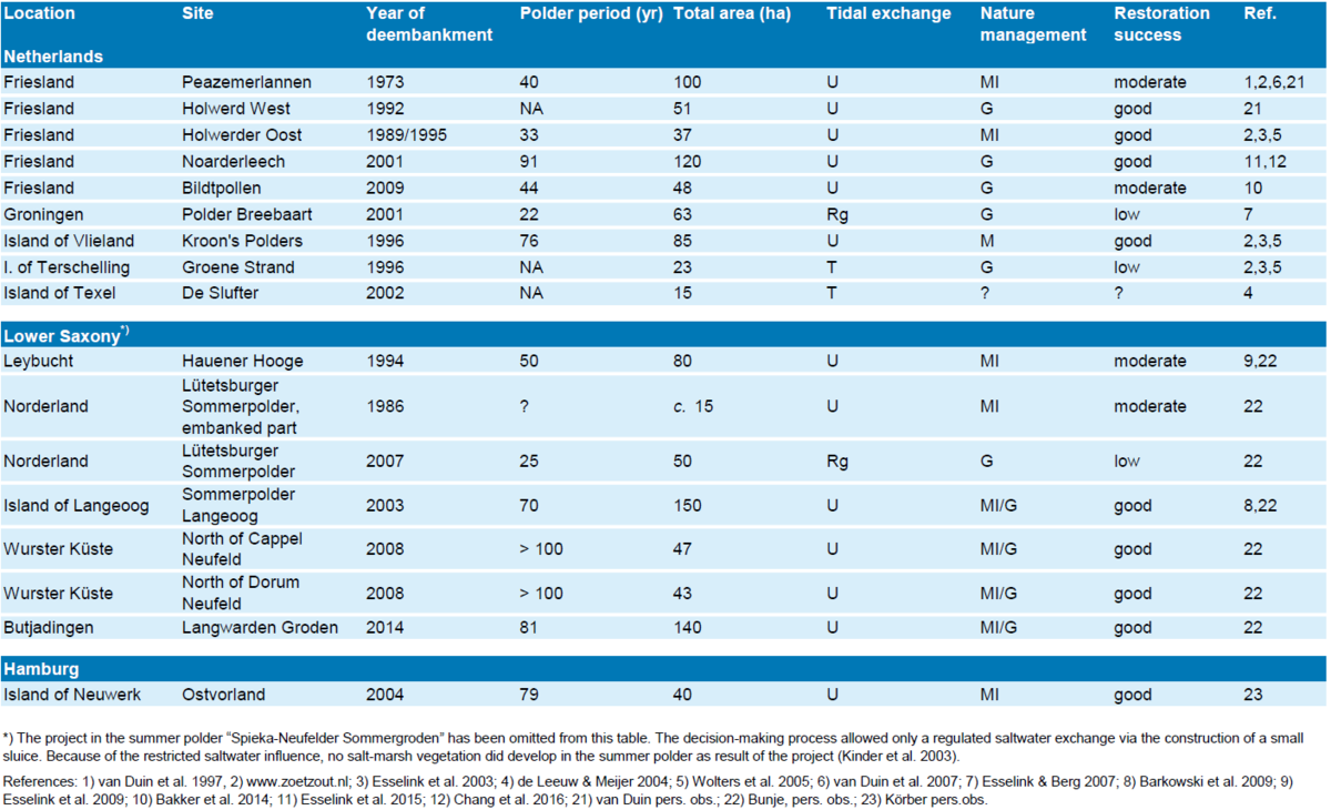
Coastal realignment involves the reintroduction of tidal influence to formerly reclaimed land through breaching of coastal embankments. Since 1973 some 18 coastal realignment projects have been implemented in the Wadden Sea Area, including 594 ha, 525 ha and 40 ha for the Netherlands, Lower Saxony, and Hamburg, respectively (Table 2). Since the previous QSR, such coastal realignment projects were carried out in Lower Saxony (140 ha) and Netherlands (48 ha).
Table 2. Overview of coastal realignment sites in the Wadden Sea. The degree of restoration success was based on expert judgement according to the extent and diversity of salt marsh vegetation. Tidal exchange is unrestricted (U), regulated (Rg) or unrestricted only above an elevated threshold (T). Nature management varies between minimum intervention (MI), livestock grazing (G) and mowing (M). NA = no information available.
Key factor in these projects is the re-introduction of tidal influence in areas that have been embanked for decades to centuries. These areas are mainly summer polders that have been reclaimed from artificial salt marshes, but also include beach plains and former dune slacks. Tidal influence can be restored completely by the removal of the embankment, or partly by interruption of the function of sluices, the installation of new sluices, culverts or dams. The success rate varies from low to high with different salt marsh plant species establishing. Ageing (§ 2.3), low tidal amplitude and silting up of the sublittoral zone may be considered as limiting factors for both naturalness and species diversity. Especially sites with regulated tidal access (Polder Breebaart and Lütetsburger Sommerpolder) have a low success rate. In case, the aim of restoration is to develop a characteristic salt marsh with different vegetation zones, ageing may appear a constraint. If the aim is also to maintain a high species diversity, implementation of an unrestricted tidal access and a moderate grazing regime seem the best ingredients for success (Wolters et al., 2005).
The current shape of the mainland salt marshes in the Wadden Sea is strongly determined by the history of successive land claims and salt marsh works. Consequently, the great majority of the present mainland salt marshes are only narrow fringes along the seawalls. It follows that in very few situations these salt marshes feature a complete hydrodynamic gradient of natural wide salt marshes (Esselink, 2000). In addition to the support for extension of the current marshes, de-embankment of summer polders will specifically contribute to the restoration of wide marshes (Esselink et al., 2009, 2015).
It is important that restoration sites are monitored regularly from before the de-embankment up to 10–20 years thereafter, with sedimentation, surface-elevation change and vegetation development as the most important parameters (Wolters et al., 2005; Esselink et al., 2015). This will increase the understanding of the processes involved in salt marsh establishment and allows adaptation of the management or engineering (e.g. removal of sediment blockades, changing the tidal inlet). It is also important to state clear and objective targets which can easily be assessed. Not only is the setting of targets indispensable for the assessment of restoration success, it is also of crucial importance in the process of gaining and retaining the necessary support from policy makers and society.
2.10 Restoration of artificial foreland salt marshes towards a more natural state
Artificial foreland salt marshes on the mainland make up about 50 % of the current Wadden Sea salt marshes (Table 1, Figure 2). During the last quarter of the twentieth century, management aims of the artificial foreland salt marshes have shifted from agricultural exploitation and land claim to nature conservation. The construction of the dense artificial drainage system at an early stage of marsh initiation prevented a natural creek system to develop (Figure 6). Enhanced by the regular upkeep of the drainage system, this may explain to a certain extent the very flat topography, and hence a limited vegetation diversity of these marshes. Furthermore, salt marsh works created an environment for the development of salt marshes on sites where at that time hydrodynamic forces were too strong for natural marshes to develop. The fixed position of groynes and the limited size of the sedimentation fields within the salt marsh works both limit the possibilities to increase naturalness.
In order to enhance the natural character of the artificial salt marshes, two strategies may be followed. Firstly, the upkeep of the artificial drainage system may be discontinued (Figure 10; § 2.6). The second strategy is to re-design the salt marsh on the base of landscape engineering. This may be applied to diminish the extensive drainage system, to enhance topographic variability, vegetation diversity, and habitat suitability for birds. This second strategy is followed in some restoration projects in Lower Saxony in two kinds of approaches, namely:
- Restoration imposed by compensation measures. In order to retard or setback succession, part of the Leybucht salt marsh (13 ha work area, effective range of influence about 100 ha) was rewetted by top-soil removal, filling up parts of the drainage system and restoring former creeks.
- Restoration in combination with coastal defence. In order to strengthen the seawall, salt marshes were traditionally used for clay extraction. Rectangular and deep clay pits were dug, and within these pits, salt marsh had to develop from the level of the intertidal flat (Figure 14). At some coastal stretches in Lower Saxony, the possibility to extract clay in inland areas is limited, and seawall reinforcement is partly dependent on clay from the salt marsh. Nowadays, this demand for clay is combined with restoration aims and re-designing the artificial salt marsh (Figure 15). Compared to the traditional approach, clay pits may be larger in area, but are shallower. The national park of Lower Saxony uses strict criteria for the selection of suitable areas for digging:
- the vegetation should be in a late-successional stage (Elytrigia atherica vegetation) due to artificial drainage,
- in order to enhance sedimentation, there should be a possibility to connect the clay pit to a nearby creek,
- the size and maximum depth are defined per location,
- these measures are carried out only in areas with low chance of natural development, and where salt marshes have to improve into a favourable conservation status.
Only when all criteria lead to an increased naturalness of the salt marsh, clay extraction is allowed. After removal of the sediment, and occasionally, the reconstruction of former creeks, no further measures are taken. Each project is accompanied by a monitoring programme for at least ten years.
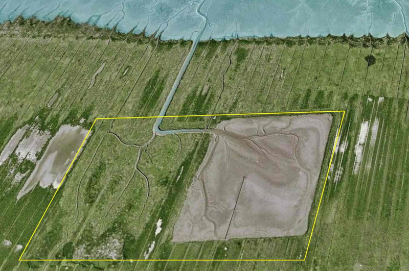
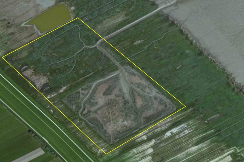 Figure 14. Clay extraction according to the traditional method in the salt marsh of the Jadebuse near Dangast, Lower Saxony. Left: Aerial view in 2000 on a 38-year old clay pit and a one-year old clay pit side by side. In both pits, a natural-like dendritic creek system developed (Photo: 2017 GeoBasis-DE/BKG on Google Earth); Right: same clay pits about 15 years later with establishing vegetation in the youngest clay pit (Photo: 2017 Earthstar Geographics SIO on Bing Maps by Microsoft).
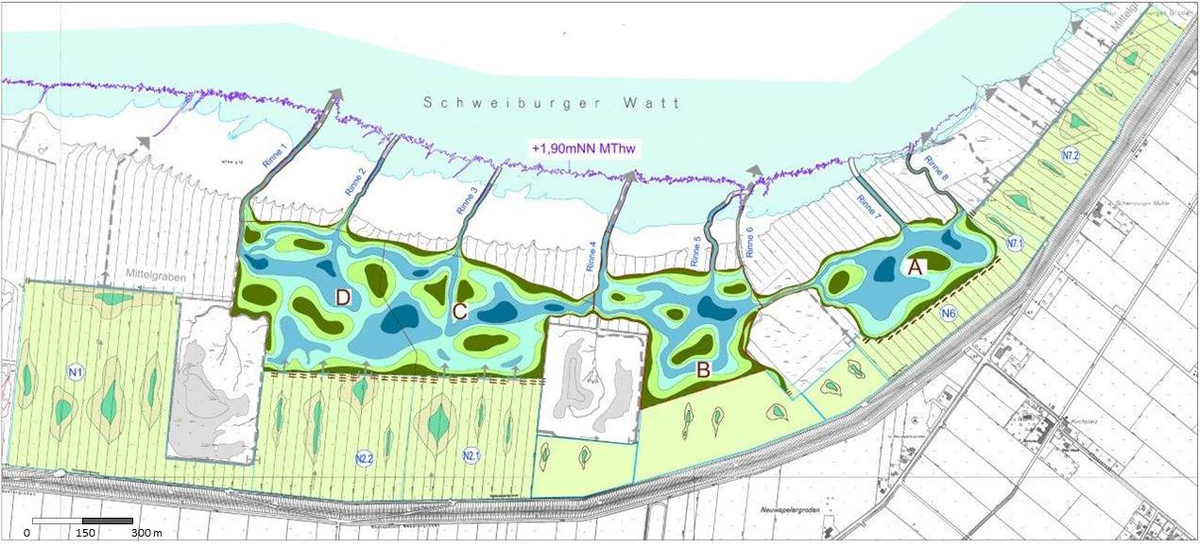
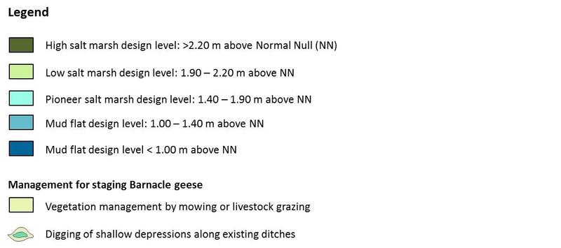
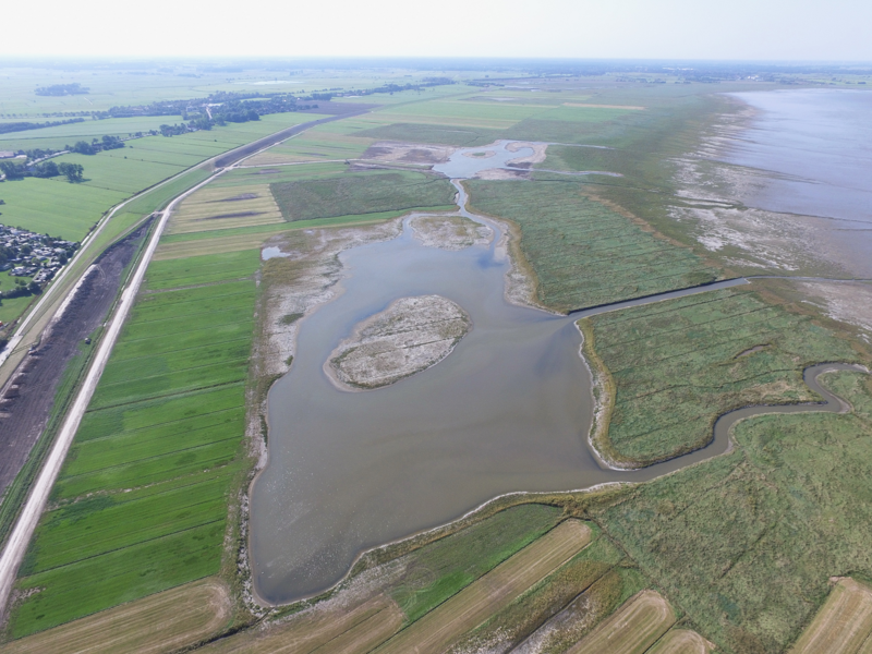 Figure 15. Example of re-designing and rewetting an artificial salt marsh after clay extraction by removing the top soil in the Neuwapeler Außengroden, Jadebusen, Lower Saxony. The photo shows the re-designed sections A and B (90° rotated). (Photo and schematic overview: Planungsgruppe Grün, Herr Sprötge; legend translated and modified by the authors).
3. Assessment
3.1 Introduction/ Summary
Salt marshes form the upper part of the intertidal zone, the interface between land and sea, and are strongly controlled by geomorphological, physical and biological processes, such as sedimentation in interaction with the vegetation, tidal regime and wind-wave pattern. They constitute a habitat for a wide range of organisms.
The general trilateral aim for salt marshes is an adequate conservation of the full range of variety of salt marshes in order to allow natural processes to operate within this habitat, with special emphasis on flora and fauna and by this to maintain or restore a favourable conservation status. In order to reach this aim, the following five targets for salt marshes have been agreed upon and framed in the Wadden Sea Plan (CWSS, 2010):
- To maintain the full range of variety of salt marshes typical for the Wadden Sea landscape
- To achieve an increased area of salt marshes with natural dynamics
- To achieve an increased area of natural morphology and dynamics, including natural drainage of mainland salt marshes, under the condition that the present surface area is not reduced
- To maintain a salt marsh vegetation diversity reflecting the geomorphological conditions of the habitat with variation in vegetation structure
- To maintain or to achieve favourable conditions for all typical species.
3.2 To maintain the full range of variety of salt marshes
Target evaluation
From a morphological view, four types of salt marsh may be distinguished in the Wadden Sea, viz.: (a) back-barrier salt marshes, (b) foreland salt marshes (c) Hallig salt marshes and (d) green beaches, (§ 2.1). These categories are related to the geomorphology of the Wadden Sea landscape, and should therefore be considered as landform types. The harmonized TMAP salt marsh surveys, however, cover vegetation and habitat types only. Mapping of landform types was recommended in the 2009 QSR (Esselink et al., 2009). This recommendation has not been fully implemented yet, however, which obstructs an evaluation of this target in quantitative terms. For practical reasons, salt marsh habitats of green beaches were merged with back-barrier salt marshes into the group of barrier-connected salt marshes.
Summer polders should not be considered as salt marsh, because the flooding by seawater is generally too infrequent for halophytic vegetation to develop. De-embankment of summer polders, however, may specifically contribute to the restoration of wide salt marshes.
Conclusions
- Barrier-connected salt marshes make up about 40 % of the salt marshes in the Wadden Sea. To a great extent and from a geomorphological point of view, these salt marshes can be classified as natural salt marsh. Since the 1995/2001 TMAP survey, these salt marshes showed a considerable natural expansion.
- Foreland salt marshes on the mainland make up more than 50 % of the salt marsh area in the Wadden Sea. The present salt marshes have largely been developed from coastal engineering or salt marsh works. In the Wadden Sea, enhancement of salt marsh development goes back to at least the 16th century. Hence, besides their value for nature conservation, man-made salt marshes also form a cultural-historical entity of the Wadden Sea landscape.
- The size of the foreland salt marshes is generally dependent on the upkeep of the brushwood groynes at the seaward marsh edge. Natural expansion without human intervention is the exception, and is mainly confined to the Schleswig Holstein region and to the Leybucht and Jadebusen in Lower Saxony.
- Because foreland salt marshes generally feature high accretion rates, their vegetation succession may evolve relatively quickly. Consequently, mainland salt marshes are susceptible to ageing.
- Barrier-connected salt marshes have relatively low accretion rates: on average only slightly higher than current sea-level rise. This does not imply that sea level rise forms a threat to these salt marshes on the short term, since there are various mechanisms for salt marshes to adapt to sea-level rise. On the long term, however, it is envisaged that these marshes cannot keep pace with the expected accelerated rates of sea-level rise.
- Hallig salt marshes are generally spatially fixed by revetments. The Halligen are a highly valued cultural-historical entity in the Wadden Sea landscape. In most cases, accretion rates are lower than the current local level of sea-level rise. An accelerated sea level rise is therefore considered as major future threat to Hallig salt marshes.
- Summer polders receive very little sediment, and therefore they cannot keep up with the current sea-level rise. Vertical accretion may successfully be restored, however, by de-embankment or coastal realignment.
3.3 To achieve an increased area of salt marshes with natural dynamics
Target evaluation
This target aims at an increased size of natural salt marshes (CWSS, 2010), where natural by definition implies not have been affected by anthropogenic influences. This means that both geomorphology and vegetation have not been influenced by any human intervention: neither by engineering practices nor by vegetation management. Instead, here natural processes are still in place, and have been so since the salt marsh started to develop. The target has also been evaluated in the 2009 QSR (Esselink et al., 2009). Most of this evaluation is still valid.
In line with the preceding QSRs, natural expansion of salt marshes has continued with a remarkable over 40 % expansion of the barrier-connected islands salt marshes and a continued natural expansion of foreland salt marshes in Schleswig Holstein. A complete net increase could not be assessed, because new survey data for Lower Saxony was not yet available. In the four remaining sectors, the total extent of salt marshes increased by more than 2,600 ha compared to the 2009 QSR, and by more than 3,750 ha (=15 %) in comparison with the 2004 QSR (Bakker et al., 2005).
The larger part of the barrier-connected salt marshes are located on the so-called island tails of islands West of the Elbe estuary. These islands undergo a (bio)geomorphic succession (see report on "Beaches and dunes"; de Groot et al., 2016). The construction of an artificial dune ridge on some islands accelerated this succession. To restore an affected island tail to its original state may prove impossible, because large-scale biogeomorphic processes are dominant. De Groot et al. (2016) therefore generally recommend to refrain from intervention. Only in case when bottlenecks for pioneer species are perceived, these authors advise to restore actively hydrodynamic and aeolian processes locally to set back vegetation succession.
Conclusions
- In the Wadden Sea, natural salt marshes are mainly found as sandy barrier-connected (island) salt marshes. At various sites, the size of these salt marshes is much greater today than during historical times due to the construction of artificial dune ridges, independent of the above-mentioned recent expansion of the barrier-connected islands salt marshes. There is currently greater concern about the loss of natural diversity than the areal extent of these marshes.
- The former construction of artificial dune ridges on some islands and on the Skallingen peninsula did not only facilitate the extension of barrier-connected salt marshes, but also resulted in reduced spatial dynamics and an accelerated vegetation succession of these salt marshes.
- Re-introduction or restoration of geomorphological processes, may locally result in a greater spatial and temporal variation in barrier-connected salt marshes, and counterbalance ageing in part of these marshes.
- The naturalness of barrier-connected salt marshes that have been disturbed by artificial drainage may be restored by filling up drains and excavating former creeks and depressions.
- On the mainland coast, the size of clayey foreland salt marshes is below historic reference values. The great majority of these salt marshes are artificial, since they developed from salt marsh works (see above). Natural foreland salt marshes are relatively rare, and found almost only in Schleswig Holstein, and in the Leybucht and Jadebusen in Lower Saxony.
- Artificial foreland salt marshes are regarded as semi-natural, which cannot be restored to completely natural salt marshes.
3.4 To achieve an increased natural morphology and dynamics, including natural drainage of mainland salt marshes, under the condition that the present surface area is not reduced
Target evaluation
In order to induce a more natural morphology of the artificial foreland salt marshes, maintenance of the artificial drainage system was discontinued in over 70 % of the area (§ 2.6; Figure 8). As a result, salt marshes slowly develop towards a state that features elements and processes that are more natural such as the development of depressions and the build-up of levees (Figure 7; Esselink et al., 1998). Neglect of the artificial drainage may further lead to rewetting of the salt marsh, which retards vegetation succession (Esselink et al., 2009). The development of a natural creek system is lacking behind, however.
Although after abandonment, part of the artificial drainage system is silted up relatively quickly, the pattern of the straight draines may be very resilient. A natural system with meandering creeks normally starts to develop in a very early stage of salt marsh development, i.e. prior to and concurrent with the establishment of the first pioneer vegetation (§ 2.5; Figure 6). Once a salt marsh has been formed, however, creeks remain relatively stable. This implies that in existing salt marshes, straight drains will not easily evolve into meandering creeks. Meandering creeks may develop in depressions (Figure 7), and also in expanding marshes, in the transition zone from pioneer marsh to the intertidal flat (Figure 6).
An alternative strategy to enhance the natural morphology of artificial salt marshes has been applied in some restoration projects in Lower Saxony. This strategy entails a re-design of the salt marsh on the base of landscape engineering (§ 2.10). The strategy was employed in restoration projects imposed by compensation measures, and in salt marsh restoration in combination with clay extraction for coastal defence.
The great majority of the present mainland salt marshes form only a narrow fringe along the coast. Consequently, in only few situations, these salt marshes feature the complete hydrodynamic gradient of natural wide salt marshes. De-embankment of summer polders will specifically contribute to the restoration of wide marshes.
Natural salt marshes are generally spatial dynamic: they either expand or erode (Figure 6). Most of the existing salt marshes, however, are depending on brushwood groynes for protection against erosion. In practice, this implies that their seaward end has become fixed. Restoration of spatial dynamics would require an adaptive long-term management of the brushwood groynes. A temporary phase of neglect and erosion might induce space where new pioneer salt marsh can develop once the groynes are reconstructed again.
Conclusions
- The target has been realized to a considerable extent. In response to the neglect of the artificial drainage, artificial salt marshes slowly develop a more natural morphology.
- The straight pattern of the artificial drainage is expected to be very resilient. Development of meandering creeks is confined to salt marsh depressions and to the transition zone from pioneer marsh to the intertidal flats.
- Most existing mainland salt marshes are relatively narrow. De-embankment of summer polders may contribute to the restoration of wide salt marshes, which feature a greater internal hydrodynamic gradient.
- In comparison with natural salt marshes, artificial salt marshes lack spatial dynamics through fixation of the seaward edge by the brushwood groynes. An adaptive management of the groynes is required to allow erosion temporarily, and to create chances for new pioneer marsh to develop.
3.5 To maintain a salt marsh vegetation diversity reflecting the geomorphological conditions of the habitat with variation in vegetation structure
Target evaluation
This target has been evaluated extensively in the 2009 QSR (Esselink et al., 2009). Most of this evaluation is still valid.
From the evaluation of the previous target, it follows that an increased natural morphology is a pre-requisite in order to achieve improved vegetation diversity in artificial salt marshes. In some artificial marshes, increased vegetation diversity has actually been observed as a result of change in management and an increased natural morphology. Whereas being a common process in most artificial marshes, ageing may be retarded or prevented in marshes with an improved morphology.
Also barrier-connected salt marshes are susceptible to ageing. In salt marshes that have been influenced by human intervention, such as the construction of an artificial dune ridge or artificial drainage, succession and dominance of Elytrigia atherica vegetation is enhanced. Natural dynamics may prevent, or at least hamper this succession.
On the trilateral level, a method for the evaluation and assessment of vegetation diversity still has to be developed. Therefore, an evaluation of the target cannot be given yet.
Objectives for nature conservation and management may differ, not only among sectors, but partly also among salt marsh sites of the same sector. There are two kind of approaches, viz. (§ 2.7):
- the prime objective is a vegetation development in relation to the geomorphological conditions with a minimum of anthropogenic influences
- the main aim is to prevent dominance by species-poor vegetation of late successional stages, and to preserve and enhance vegetation diversity in a semi-natural landscape with livestock grazing as an important management tool. In this approach vegetation diversity is thus the outcome of the interaction between geomorphological conditions and grazing.
The two approaches have now successfully been integrated in the Wadden Sea Plan 2010 (CWSS, 2010).
Conclusions
- An increased natural morphology is a pre-requisite in order to achieve improved vegetation diversity in artificial salt marshes.
- On the trilateral level, a method for the evaluation and assessment of vegetation diversity still has to be developed.
- In principle, there are two different views on the target, and on how the target can be reached. The two views have been integrated in the Wadden Sea Plan 2010 (CWSS, 2010).
3.6 To maintain favourable conditions for all typical species
Target evaluation
The aim is “to reduce and/or diversify grazing in order to increase the natural dynamics or the diversity of vegetation and associated animal species in salt marshes, reflecting the geomorphological conditions of the habitat” (CWSS, 2010). The evaluation of the other targets shows that a step forward has been made towards this aim.
It may be questioned whether this target can be evaluated in a sound way. It will be clear that it is not feasible to assess all characteristic salt marsh species in a standardized programme. There are simply too many groups of organisms living in salt marshes, and hence, a selection of indicator or umbrella species or species group might be required. Furthermore, an evaluation method would have to be developed.
How to proceed with the evaluation of the target, may also differ according to the prime objective for nature conservation (see § 3.5). It should be recognized that species differ in their habitat requirements, and hence, in order to preserve favourable conditions for all typical species, a variety of salt marsh habitats is a prerequisite. If the management objective is “a vegetation development in relation to the geomorphological conditions with a minimum of anthropogenic influences”, the different salt marsh habitats present may be accepted as the natural variety of habitats.
If the management objective is to preserve and enhance vegetation diversity, and livestock is accepted as management tool, the variety of habitats may be manipulated. In this setting, large-scale mosaics of different management regimes may support the maintenance of the greatest possible habitat and species diversity (Table 3; § 2.7; Wanner et al., 2014; van Klink et al., 2016).
Conclusions
- It is probably not feasible to evaluate the target in a sound way. Besides, an evaluation method is lacking, and would have to be developed first.
- Where applicable, a large-scale mosaic of different management regimes may support the different habitat requirements of most of the species.
Table 3. Overview of the diversity of salt marsh plants and animals in relation to the management regime in Noord-Friesland Buitendijks (NL). Stocking density and rotational treatment refer to grazing by livestock. Darker shading indicates a higher number of species. (With geese and voles: darker shading indicates higher numbers of individuals). For birds and invertebrates, every regime has its own characteristic species. From a large-scale perspective, diversity can be maximized by using a spatial mosaic of different management regimes. The index values for passerines during winter are based on estimates. From: de Vlas et al. (2013).
4. Recommendations
4.1 Recommendations for monitoring and research
Most recommendations for monitoring and research from the 2009 QSR, sometimes slightly revised, are still valid:
- The monitoring according to the TMAP guidelines should be fully implemented. In order to assess the “favourable conservation status” of the Habitat Directive on the trilateral level, the TMAP Salt Marshes and Dunes Expert Group (SMDEG) concluded that the TMAP monitoring according to TMAP guidelines is a pre-requisite. Therefore, in order to allow a trilateral assessment, implementation of the TMAP salt marsh monitoring programme by Denmark is awaited.
- Distinction of secondary pioneer vegetation in the TMAP typology. The primary pioneer zone and the secondary pioneer plant communities in the inner salt marsh are not ecologically equivalent. In order to assess both communities separately, it is advised to subdivide the following two TMAP vegetation types: the Spartina anglica type (S.1.1) and of the Salicornia spp. / Suaeda maritima type (S.1.2; Petersen et al., 2014).
- The monitoring according to the TMAP guidelines should be extended with monitoring of marsh surface elevation. Surface elevation is a basic measure for all salt marshes. Change of surface elevation is an essential parameter for the evaluation of salt marsh development. Monitoring of surface elevation on selected permanent transects or monitor stations is therefore strongly recommended. This also would yield the possibility to evaluate marsh surface-elevation change on a regular base (§ 2.8).
- The monitoring according to the TMAP guidelines should be extended by monitoring plant species of the TMAP vegetation types. The TMAP monitoring programme does not provide monitoring data at the level of plant species, but on the level of plant communities only. In order to assess processes of salt marsh change, Bakker et al. (2005) recommended the annual monitoring of vegetation types at selected permanent sites in relation with elevation changes and management data. This recommendation can be specified as the monitoring of plant species in permanent plots, which is already common use in some sectors (Annex Table I.1). Ideally, this monitoring should be executed in relation with marsh elevation and management.
- Addition of landform type in GIS. This recommendation from the 2009 QSR has not been fully implemented yet (cf. § 3.2). In order to analyze vegetation maps or vegetation changes, data on substrate and salt marsh type are very relevant. So far, such information is not available at the trilateral level. The SMDEG therefore recommends the addition of standardized geomorphological map layers to the TMAP vegetation maps.
- Data harmonisation. The SMDEG successfully developed a standardized vegetation typology. In order to fully exploit the data that has been collected, harmonisation of GIS data sets is required and recommended.
- Every six years vegetation mapping according to TMAP typology shall be applied. For salt marshes the Habitat Directive requires an evaluation cycle with a time interval of six years. The SMDEG recommends to harmonize the mapping frequency with this evaluation cycle, and to adapt to a 6-year time interval for the next vegetation mappings in all sectors.
- Integration of additional relevant available data in relation to salt marshes, especially legal protection status, ownership and land use. Land use of Wadden Sea salt marshes can be subdivided into agricultural exploitation and nature conservation. These two land-use types cannot be quantified with the available data. In order to separate, for instance, agricultural exploitation by livestock grazing and grazing as management tool in nature management, the land-use types should be available in a harmonized GIS-dataset. It is recommended therefore to add a harmonized dataset on legal protection status, ownership and land use.
- Continuation of long-term study sites and incorporation of these sites into the International Long-Term Ecological Research sites (ILTER).
The following three recommendations are novel:
- Monitoring of artificial drainage in salt marshes. The current TMAP monitoring assesses the time since the last human intervention, but does not give any information about the actual status of the drainage system. The SMDEG recommends to adapt the monitoring on drainage according to a harmonized method.
- Summer polders should be monitored as landform type. Although summer polders cannot be considered salt marsh (H 1330) they are former salt marsh with a high potential for salt marsh restoration.
- A method to evaluate and assess the target “to maintain a salt marsh vegetation diversity reflecting the geomorphological conditions of the habitat with variation in vegetation structure” is lacking, and should be developed.
4.2 Recommendations for management
Advances in applied salt marsh research lead at some points to an adaptation and extension of the recommendations for management from the previous QSR (Esselink et al., 2009). Other recommendations from the previous QSR are still valid:
- The development of naturally protruding salt marshes is best guaranteed by leaving the geomorphology of both the growing marsh and the adjacent intertidal mudflats undisturbed.
- In order to allow natural creek systems developing within the salt marsh works, it is advised to refrain from any groundwork here.
- Wide salt marshes have a higher conservation value than narrow marshes. De-embankment of summer polders may specifically contribute to the restoration of wide salt marshes. Moreover, de-embankment contributes to the areal extension of the current salt marshes.
- Cliff erosion should be considered as a natural process in both natural and artificial salt marshes. It follows that cliff erosion should not automatically be interrupted by counter measures, but should be allowed as natural process given space, especially in extended marshes.
The following recommendations are new or have been revised based on advanced insights:
- At island salt marshes that have been affected by the construction of artificial dune ridges or sand dikes, and where the loss of pioneer species is very acute, a setback of vegetation succession can be pursued by restoring hydrodynamics and aeolian dynamics; otherwise it is advised to refrain from intervention in order to let natural processes take over.
- A further diminishment of the upkeep of the artificial drainage system within the salt marsh is recommended. If it is necessary to prevent waterlogging at the foot of the seawall, the upkeep of the artificial drainage should be confined to this purpose only. An alternative is an adaptive seawall construction, which is already practised at some sites in Lower Saxony.
- There are two different approaches in conservation management of Wadden Sea salt marshes (§2.7). In the German national parks, as well as in several salt marsh areas in the Netherlands and Denmark, the undisturbed course of natural processes is the main objective, and a management of minimum intervention is applied. In other salt marsh reserves, the aim is often an enhancement of biodiversity, and livestock grazing is applied to control vegetation succession. Wherever appropriate, a maximum biodiversity may be obtained by the introduction of a large-scale mosaic of different management regimes including a regime of minimum intervention.
- Artificial salt marshes are part of the cultural history of the Wadden landscape. When aiming at increasing naturalness in these marshes, considering this in the overall framework of the WSP is recommended.
- For artificial salt marshes that do not have a favourable conservation status, and which have only a low potential for increased naturalness, restoration measures, such as top-soil removal, re-arrangement of the artificial drainage system, or even a re-design of the entire marsh area may be considered.
5. Summary
Salt marshes in the Wadden Sea extend over almost 40,000 ha, which represents about 20 % of the total of coastal salt marshes in Europe. In comparison with the 2009 QSR, salt marshes continued their expansion. Leaving data from Lower Saxony aside, salt marshes increased by more than 3,750 ha since the 2004 QSR; about three-quarter of this increase occurred in barrier-connected island salt marshes.
From a morphological point of view, four types of salt marshes may be distinguished in the Wadden Sea Area, viz.: (a) back-barrier marshes, (b) foreland marshes, (c) Hallig salt marshes and (d) green beaches. In this report, the status of salt marshes is primarily based on vegetation and habitat, and less on geomorphology. In this sense, halophytic vegetation on green beaches has been merged with back-barrier salt marshes into the group of barrier-connected salt marshes. Sometimes, summer polders are mentioned as fifth salt marsh type in the Wadden Sea. In most summer polders, however, the vegetation cannot be qualified as salt marsh, since the influence of seawater is too limited. According to the most recent survey data, Wadden Sea salt marshes varied in size from less than 0.5 % up to almost 17 % per tidal area.
Despite the recent extension of salt marshes, the extent of pioneer and low-marsh vegetation types remained relatively constant, whereas vegetation of late-succession stages increased, especially Elytrigia atherica vegetation. The latter has become the most dominant vegetation type in the high-marsh zone..
In order to evaluate the status of Wadden Sea salt marshes in relation to current sea-level rise, available data on surface-elevation changes were collected. Foreland salt marshes showed on average the elevation increase (9.6 mm/yr), i.e. well above the increase rate of MHT (2.0–3.0 mm/yr). Barrier-connected salt marshes build up at about a similar rate as the increase of MHT. Surface-elevation of Hallig salt marshes lag behind MHT increase, which at least partly, may be explained by disturbance of sediment supply to these marshes by coastal protection measures. The same, but stronger disturbance plays a role in summer polders, where surface-elevation change appears negligible.
Foreland salt marshes on the mainland account for approximately 50 % of the current salt marshes in the Wadden Sea. Natural foreland salt marshes are relatively rare, however. The great majority of the foreland salt marshes developed from salt marsh works, and are therefore considered artificial. One of the targets of the Wadden Sea Plan is to transform artificial salt marshes towards a more natural state. In order to assist the decision-making and evaluation of the current state of these salt marshes, a conceptual reference model for natural foreland salt marshes is presented. An increased natural morphology is a prerequisite in order to achieve improved vegetation diversity in these salt marshes. For the realization of this target, a management strategy of minimum intervention in the drainage system is applied extensively. Compared to the previous QSR, the extent of recent drainage practices remained basically unchanged. In some artificial salt marshes in Lower Saxony, where a natural development was considered to be prevented by the former anthropogenic impact, pilot projects were launched which amounted the re-design of the entire salt marsh.
Many of the recommendations from the previous QSR are still valid. In addition, further harmonization of the data is recommended in order to make full use of the spatial-data sets that are available in the framework of TMAP monitoring.
About the authorsEsselink, P. 1, van Duin, W.E. 2, Bunje, J. 3, Cremer, J. 4, Folmer, E.O. 5, Frikke, J. 6, Glahn, M. 7, de Groot, A.V. 8, Hecker, N. 9, Hellwig, U. 10, Jensen, K. 11, Körber, P. 12, Petersen, J. 13, Stock, M. 14 1 PUCCIMAR, Ecological Research and Consultancy, Boermarke 35, 9481 HD Vries, NL 2 Artemisia-kwelderonderzoek, Graaf Willem II straat 258, 1785 KL Den Helder, NL 3 Nationalparkverwaltung Niedersächsisches Wattenmeer, Virchowstr. 1, 26382 Wilhelmshaven, DE 4 Wageningen Marine Research, Haringkade 1, 1976 CP IJmuiden, NL 5 Royal Netherlands Institute for Sea Research (NIOZ), Landsdiep 4, 1797 SZ 't Horntje (Texel), NL 6 Nationalpark Vadehavet, Havnebyvej 30, 6792 Rømø, DK 7 Miljøstyrelsen Sydjylland, Skovridervej 3, 6510 Gram, DK 8 IMARES Wageningen, Ankerpark 27, 1781AG Den Helder, NL 9 Nationalparkverwaltung Niedersächsisches Wattenmeer, Virchowstr. 1, 26382 Wilhelmshaven, DE 10 Institute for applied environmental biology and monitoring, Wurster Landstrasse 11, 27638 Wremen, DE 11 Universität Hamburg, Ohnhorststr. 18, 22609 Hamburg, DE 12 Nationalparkverwaltung Hamburgisches Wattenmeer, Neuenfelder Straße 19, 21109 Hamburg, DE 13 Nature-Consult, Hackelbrink 21, 31139 Hildesheim, DE 14 Nationalparkverwaltung Schleswig-Holsteinisches Wattenmeer, Schloßgarten 1, 25832 Tönning, DE |
References
Adam P. (1990) Saltmarsh ecology. Cambridge University Press, Cambridge. 461 pp.
Allen J.R.L. (2000) Morphodynamics of Holocene salt marshes: a review sketch from the Atlantic and Southern North Sea coasts of Europe. Quaternary Science Review 19: 1155–1231.
Allen J.R.L. & Pye K. (1992) Coastal saltmarshes: their nature and importance. In: J.R.L. Allen & K. Pye (eds). Saltmarshes. Morphodynamics, conservation and engineering significance. Cambridge University Press, Cambridge. p. 1–18.
Arens S. & Götting E. (2008) Untersuchungen zur ökologischen Entwicklung naturnaher Lahnungsfelder und ihre Stellung im Naturhaushalt. - Gutachten, gefördert von der Niedersächsischen Wattenmeerstiftung und der Niedersächsischen Lottostiftung. 81 pp.
Baart F., van Gelder P.H.A.J.M., de Ronde J., van Koningsveld M. & Wouters B. (2012) The effect of the 18.6-year lunar nodal cycle on regional sea-level rise estimates. Journal of Coastal Research 28: 511–516.
Bakker J.P. (2014) Ecology of salt marshes. 40 years of research in the Wadden Sea. Wadden Academy, Leeuwarden. 99 pp.
Bakker J.P., Esselink P. & Dijkema K.S. (1997) Salt-marsh management for nature conservation, the value of long-term experiments. Wadden Sea News Letter 1997(1): 19–24.
Bakker J.P., Bunje J., Dijkema K.S., Frikke J., Kers B., Körber P., Kohlus J. & Stock M. (2005) Salt marshes. In: Essink K., Dettmann C., Farke H., Laursen K., Lüerßen G., Marencic H. & Wiersinga W. (eds). Wadden Sea Quality Status Report 2004, Wadden Sea Ecosystem No. 19, Trilateral Monitoring and Assessment Group, Common Wadden Sea Secretariat. Wilhelmshaven. p. 163–179.
Bakker J.P., Baas A.C.W., Bartholdy J., Jones L., Ruessink G., Temmerman S. & van de Pol M. (2016) Environmental Impacts – Coastal Ecosystems. In: Quente M. & Colijn F. (eds). North Sea Region Climate Change Assessment. Springer Open. p. 275–314. doi 10.1007/978-3-319-39745-0_9.
Bakker R., Bijkerk W. & Esselink P. (2014) Monitoring effecten van verkweldering in de Bildtpollen 2009 – 2013. Eindrapport. A&W-rapport 1983, PUCCIMAR-rapport 11, Altenburg & Wymenga ecologisch onderzoek, Feanwâlden / puccimar Ecologisch onderzoek & Advies, Vries. 46 pp. + app.
Balke T., Stock M., Jensen K., Bouma T.J. & Kleyer M. (2016) A global analysis of the seaward salt marsh extent: The importance of tidal range. Water Resources Research 52: 3775–3786.
Barkowski J.W., Kolditz K., Brumsack H. & Freund H. (2009) The impact of tidal inundation on salt marsh vegetation after de-embankment on Langeoog Island, Germany – six-years time series of permanent plots. Journal of Coastal Conservation 13: 185–206.
Chang E.R., Veeneklaas R.M., Bakker J.P., Daniels P. & Esselink P. (2016) What factors determined restoration success of a salt marsh ten years after de-embankment? Applied Vegetation Science 19: 66–77.
Corenblit D., Steiger J., Gurnell A. & Tabacchi E. (2007) Darwinian origin of landforms. Earth Surface Processes and Landforms 32: 2070-2073.
Crosby S.C., Sax D.F., Palmer M.E., Booth H.S., Deegan L.A., Bertness M.D. & Leslie H.M. (2016) Salt marsh persistence is threatened by predicted sea-level rise. Estuarine, Coastal and Shelf Science 181: 93–99.
CWSS (2010) Wadden Sea Plan 2010. Eleventh Trilateral Governmental Conference on the Protection of the Wadden Sea. Common Wadden Sea Secretariat, Wilhelmshaven. 102 pp.
CWSS, World Heritage Nomination Group (2008) Nomination of the Dutch-German Wadden Sea as World Heritage Site. Wadden Sea Ecosystems 24: 1–200. Common Wadden Sea Secretariat, Wilhelmshaven.
de Leeuw C. & Meijer M.-L. (2004) Proefgebieden herstel zoet-zout overgangen in Noord Nederland. Een beschrijving van 18 projecten. Rapport RIKZ/2003.010. RIKZ, Haren, Koeman en Bijkerk, Haren. 104 pp.
de Groot A.V., Oost A.P., Veeneklaas R.M., Lammerts E.J., van Duin W.E., van Wesenbeeck B.K. (2016) Tales of island tails: biogeomorphic development and management of barrier islands. Journal of Coastal Conservation 1–11. doi:10.1007/s11852-016-0446-8 (available online)
de Vlas J., Mandema F.S., Nolte S., van Klink R. & Esselink P. (2013) Nature conservation of salt marshes. Influence of grazing on biodiversity. puccimar-report 09, puccimar Ecological Research and Consultancy, Vries. It Fryske Gea, Olterterp. 32 pp.
Dijkema K.S. (1987) Changes in salt marsh area in the Netherlands Wadden Sea after 1600. In: A.H.L. Huiskes, C.W.P.M. Blom & J. Rozema (eds). Vegetation between land and sea. Dr. W. Junk Publishers, Dordrecht. p. 42–49.
Dijkema K.S., Bossinade J.H., van den Bergs J. & Kroeze T.A.G. (1991) Natuurtechnisch beheer van kwelderwerken in de Friese en Groninger Waddenzee: greppelonderhoud en overig grondwerk. Nota GRAN 1991-2002, Rijkswaterstaat Directie Groningen, Groningen / RIN-rapport 91/10, Instituut voor Bos- en Natuuronderzoek, Texel. 156 pp.
Dijkema K.S., Nicolai A., de Vlas J., Smit C.J., Jongerius H. & Nauta H. (2001) Van landaanwinning naar kwelderwerken. Rijkswaterstaat Directie Noord-Nederland¸ Leeuwarden, Alterra, Texel. 68 pp.
Doody J.P. (2008) Saltmarsh conservation, management and restoration. Springer. 217 pp.
Esselink P. (1998) Van landaanwinning naar natuurbeheer: Recente ontwikkelingen op de Dollardkwelders. In: Essink K. & Esselink P. (eds). Het Eems-Dollard estuarium: interacties tussen menselijke beïnvloeding en natuurlijke dynamiek. Rapport RIKZ-98-020. Rijkswaterstaat Rijksinstituut voor Kust en Zee / RIKZ, Haren. pp. 79–99.
Esselink P. (2000). Nature management of coastal salt marshes. Interactions between anthropogenic influences and natural dynamics. PhD-thesis. University of Groningen, Groningen. 256 pp.
Esselink P. & Berg G.J. (2007) Beheerplan Polder Breebaart. Report 2005-100, Bureau Koeman en Bijkerk, Haren. 77 pp.
Esselink P., de Leeuw C., Graveland J. & Berg G.J. (2003) Ecologische Evaluatie Programma Herstel en Inrichting zoute wateren 1990-1999. Report RIKZ/2003.028. Rijkswaterstaat Rijksinstituut voor Kust en Zee / RIKZ, Middelburg. 49 pp. + app.
Esselink P., Petersen J., Arens S., Bakker J.P., Bunje J., Dijkema K.S., Hecker N., Hellwig U., Jensen A.-V., Kers A.S., Körber P., Lammerts E.J., Stock M., Veeneklaas R.M., Vreeken M. & Wolters M. (2009) Salt Marshes. Thematic Report No. 8. In: Marencic H. & de Vlas J. (eds). Quality Status Report 2009. Wadden Sea Ecosystem No. 25. Common Wadden Sea Secretariat, Trilateral Monitoring and Assessment Group, Wilhelmshaven, Germany. 54 pp.
Esselink P., Bos D., Oost A.P., Dijkema K.S., Bakker R. & de Jong R. (2011) Verkenning afslag Eems-Dollardkwelders. PUCCIMAR-rapport 02. A&W-rapport 1574. PUCCIMAR Ecologisch onderzoek en advies, Vries, Altenburg & Wymenga, Ecologisch onderzoek BV, Veenwouden. 79 pp.
Esselink P., Bos D., Daniels P., van Duin W.E. & Veeneklaas R.M. (2015) Van polder naar kwelder: tien jaar kwelderherstel Noarderleech. PUCCIMAR-rapport 06, PUCCIMAR Ecologisch Onderzoek & Advies, Vries. 209 pp.
Frederiksen M. & Dahl K. (1994) Birds and their ecology in the Wadden Sea. Proceedings of the 8th International Scientific Wadden Sea Symposium, Esbjerg 1993. Ophelia Supplement 6. Marine Biological Laboratory, Helsingør.
French J.R. & Stoddart D.R. (1992) Hydrodynamics of salt marsh creek systems: implications for marsh morphological development and material exchange. Earth Surface Processes & Landforms 17: 235–252.
Jensen J.,Dangendorf S., Wahl T. & Steffen H. (2014) Meeresspiegeländerungen in der Nordsee: Vergangene Entwicklungen und zukünftige Herausforderungen mit einem Fokus auf die Deutsche Bucht. Hydrologie und Wasserbewirtschaftung 58: 304–323.
Kinder M., Främbs H., Hielen B. & Mossakowski D. (2003) Regeneration von Salzwiesen in einem Sommergroden an der Nordseeküste: E+E Vorhaben "Salzwiesenprojekt Wurster Küste". Natur und Landschaft 78: 343–353.
Kirwan M.L. & Murray A.B. (2007) A coupled geomorphic and ecological model of tidal marsh evolution. Proceedings of the National Academy of Sciences of the United States of America 104: 6118–6122.
Kirwan M.L., Temmerman S., Skeehan E.E., Guntenspergen G.R. & Fagherazzi S. (2016) Overestimation of marsh vulnerability to sea level rise. Nature Climate Change 6: 253–260.
Linders H.W., Meyer-Spethmann U. & Andretzke H. (2013) Kompensationsmaßnahme Ostheller Norderney: Monitoring 2012. Report. Ecoplan Bürogemeinschaft Landschaftsplanung, Leer. 88 pp.
Long S.P. & Mason C.F. (1983) Saltmarsh Ecology. Blackie, Glasgow.
Meltofte H., Blew J., Frikke J., Rösner H.-U. & Smit C.J. (1994) Numbers and distribution of waterbirds in the Wadden Sea. Results and evaluation of 36 simultaneous counts in the Dutch-German-Danish Wadden Sea 1980–1991. IWRB Publication 34 / Wader Study Group Bull. 74: 1-192.
Metzing D. & Gerlach A. (2005) Entwicklung von Flora und Vegetation in der Pütte Petersgroden. Forschungszentrum Terramare Berichte 14: 21-35.
Metzing D. & Gerlach A. (2008) Impacts of clay excavation on the local flora of salt marshes. Senckenbergiana maritima 38: 107-113.
Michaelis H. (2008) Langzeitstudie zur Entwicklung von Höhenlage, Sediment, Vegetation und Bodenfauna in Landgewinnungsfeldern. Untersuchungsbericht 02/08 (internal report). Niedersächsischer Landesbetrieb für Wasserwirtschaft, Küsten- und Naturschutz, Forschungsstelle Küste, Norderney. 60 pp.
Odum W.E. (1988) Comparative ecology of tidal freshwater and salt marshes. Annual Review of Ecology and Systematics 19: 147–176.
Nolte S. (2014) Grazing as a nature management tool. The effect of different livestock species and stocking densities on salt-marsh vegetation and accretion. PhD-thesis. University of Groningen, Groningen. 245 pp.
Nolte S., Koppenaal E.C., Esselink P., Dijkema K.S., Schuerch M., de Groot A.V., Bakker J. P. & Temmerman S. (2013) Measuring sedimentation in tidal marshes: a review on methods and their applicability in biogeomorphological studies. Journal of Coastal Conservation 17: 301–325.
Petersen J., Kers B. & Stock M. (2014) TMAP-typology of coastal vegetation in the Wadden Sea area. Wadden Sea Ecosystems 32: 1–86. Common Wadden Sea Secretariat, Wilhelmshaven.
Reise K. (1994) Das Schlickgras Spartina anglica: die Invasion einer neue Art. In: Lozán J.L., Rachor E., Reise K., von Westernhagen H. & Lenz W. (eds). Warnsignale aus dem Wattenmeer. Blackwell Wissenschafts-Verlag, Berlin. p. 211–214.
Rupprecht F., Wanner A., Stock M. & Jensen K. (2015) Succession in salt marshes – large-scale and long-term patterns after abandonment of grazing and drainage. Applied Vegetation Science: 18: 86–98.
Schwarz C., Ye Q.H., van der Wal D., Zhang L.Q., Bouma T., Ysebaert T. & Herman P.M.J. (2014) Impacts of salt marsh plants on tidal channel initiation and inheritance. Journal of Geophysical Research 119: 385-400.
Schindler M., Karius V., Arns A., Deicke M. & von Eynatten H. (2014) Measuring sediment deposition and accretion on anthropogenic marshland - Part II: The adaptation capacity of the North Frisian Halligen to sea level rise. Estuarine, Coastal and Shelf Science 151: 246-255.
Stock M. (1997) Salt marsh management in the National Park "Schleswig-Holsteinisches Wattenmeer". Wadden Sea Newsletter 1997(1): 11–15.
Stock M. (2011) Patterns in surface elevation change across a temperate salt marsh plat from in relation to sea-level rise. In: Karius V., Hadler H., Deicke M., v. Eynatten H., Brückner H. & Vött A. (eds). Dynamische Küsten - Grundlagen, Zusammenhänge und Auswirkungen im Spiegel angewandter Küstenforschung, Coastline Reports 17: 33–48.
Stock M. & Maier M. (2016) Salzwiesenschutz im Nationalpark Wattenmeer – ein Überblick. Vogelkundliche Berichte aus Niedersachsen 44: 131-156.
Temmerman S., Govers G., Wartel S. & Meire P. (2003) Spatial and temporal factors controlling short-term sedimentation in a salt and freshwater tidal marsh, Scheldt estuary, Belgium, SW Netherlands. Earth Surface Processes and Landforms 28: 739–755.
Temmerman S., Bouma T.J., Govers G. & Lauwaet D. (2005a) Flow paths of water and sediment in a tidal marsh: Relations with marsh developmental stage and tidal inundation height. Estuaries 28: 338–352.
Temmerman S., Bouma T.J., Govers G., Wang Z.B., de Vries M.B. & Herman P.M.J. (2005b) Impact of vegetation on flow routing and sedimentation patterns: Three-dimensional modeling for a tidal marsh. Journal of Geophysical Research-Earth Surface 110. F04019, 18 pp.
Temmerman S., Bouma T.J., van de Koppel J., van der Wal D., de Vries M.B. &. Herman P.M.J (2007) Vegetation causes channel erosion in a tidal landscape. Geology 35: 631–634.
Townend I., Fletcher C., Knappen M. & Rossington K. (2011) A review of salt marsh dynamics. Water and Environment Journal 25: 477–488.
van Duin W.E., Dijkema K.S. & Zegers J. (1997) Veranderingen in bodemhoogte (opslibbing, erosie en inklink) in de Peazemerlannen. IBN-rapport 326. Instituut voor Bos- en Natuuronderzoek (IBN-DLO), Wageningen. 104 pp.
van Duin W.E., Dijkema K.S. & van Leeuwen P.-W. (2007) Uitgangssituatie maaiveldhoogte en kweldervegetatie in de Paezemerlannen (2006). Report C128/07. IMARES, Wageningen. 79 pp.
van Duin W.E., Jongerius H., Nicolai A., Jongsma J.J., Hendriks A. & Sonneveld C. (2016) Friese en Groninger Kwelderwerken: Monitoring en beheer 1960 - 2014. WOt-technical report 68. Wageningen University & Research, Wageningen. 91 pp.
van Eerde L.A.E. (1942) De landaanwinning van het Noorderleegs Buitenveld. Tijdschrift Nederlands Aardrijkskundig Genootschap 59: 1–23.
van Klink R. (2014) Of dwarves and giants – how large herbivores shape arthropod communities on salt marshes. PhD-thesis. University of Groningen, Groningen. 227 pp.
van Klink R., Nolte S., Mandema F.S., Lagendijk D.D.G., WallisdeVries M.F., Bakker J.P., Esselink P. & Smit C. (2016) Effects of grazing management on biodiversity across trophic levels – the importance of livestock species and stocking density in salt marshes. Agriculture, Ecosystems and Environment 235: 329–329.
van Wesenbeeck B.K., Esselink P., Oost A.P., van Duin W.E., de Groot A.V., Veeneklaas R.M., Balke T., van Geer P., Calderon A.C. & Smale A. (2014) Verjonging van half-natuurlijke kwelders en schorren. Rapport nr. 2014/OBN196-DK. VBNE, Vereniging van Bos- en Natuurterreineigenaren, Driebergen. 73 pp.
Veeneklaas R.M. (2013) Adaptation and dispersal of the native invasive salt marsh species Elytrigia atherica. Thesis University of Groningen, Groningen. 149 pp.
Vos P.C. & Knol. E. (2015) Holocene landscape reconstruction of the Wadden Sea area between Marsdiep and Weser. Netherlands Journal of Geosciences 94: 157–183.
Wahl T., Jensen J., Frank T. & Haigh I. (2011) Improved estimates of mean sea level changes in the German Bight over the last 166 years. Ocean Dynamics 61: 701–715.
Wanner A., Suchrow S., Kiehl K., Meyer W., Pohlmann N., Stock M. & Jensen K. (2014) Scale matters: Impact of management regime on plant species richness and vegetation type diversity in Wadden Sea salt marshes. Agriculture, Ecosystems and Environment 182: 69–79.
Wiersma A.P., Oost A.P., van der Berg M.W., Vos P.C., Marges V. & de Vries S. (2009) Geomorphology. Thematic Report No. 9. In: H. Marencic & J. de Vlas (eds). 2009. Quality Status Report 2009. Wadden Sea Ecosystem No. 25. Common Wadden Sea Secretariat, Wilhelmshaven.
Wolters M., Garbutt A. & Bakker J.P. (2005) Salt-marsh restoration: evaluating the success of de-embankments in north-west Europe. Biological Conservation 123: 249–268.
Yapp R.H., Johns D. & Jones O.T. (1917) The salt marshes of the Dovey estuary. Journal of Ecology 5: 65–103.
This report should be cited as: Esselink P., van Duin W.E., Bunje J., Cremer J., Folmer E.O., Frikke J., Glahn M., de Groot A.V., Hecker N., Hellwig U., Jensen K., Körber P., Petersen J. & Stock M. (2017) Salt marshes. In: Wadden Sea Quality Status Report 2017. Eds.: Kloepper S. et al., Common Wadden Sea Secretariat, Wilhelmshaven, Germany. Last updated 21.12.2017. Downloaded DD.MM.YYYY. qsr.waddensea-worldheritage.org/reports/salt-marshes

